830
September 2014
PHOTOGRAMMETRIC ENGINEERING & REMOTE SENSING
possible actions by other drivers and pedestrians based on
behavior within their current surroundings. The driver of our
tactical personnel carrier will receive visible, audible or tactile
(steering wheel vibration) prompts for the type of defensive
maneuver to take to avoid a dangerous situation.
The corporation in our story has been proactive in acquiring
hardware/software to develop 3D views of the entire campus
and buildings (exterior and interior). This emergency planning
provides first responders with a critical baseline to work from
as they can develop on-the-spot scenarios to determine ingress/
egress routes to resolve situations. The campus Site Security
Manager (SSM) and his IT team reviewed several 3D collection
systems and decided to go with the Autodesk solution. After a
few days of training, a nadir imagery map of the campus is first
produced to provide an overview of their facilities. The campus
emergency planning team decided to use a UAV with GoPro
camera and waypoint onboard hardware/software to capture
all building facades with perimeter areas including parking lots
and roads. With the Autodesk option, they were able to produce
3D realistic views with 360 degree views of any point on the
campus. AaronMorris, PhD (Reality Capture ProgramManager
at Autodesk) discussed that corporate site managers can now,
after the exterior baseline, conduct weekly UAV traverses
of their facilities for security risk assessments. In addition to
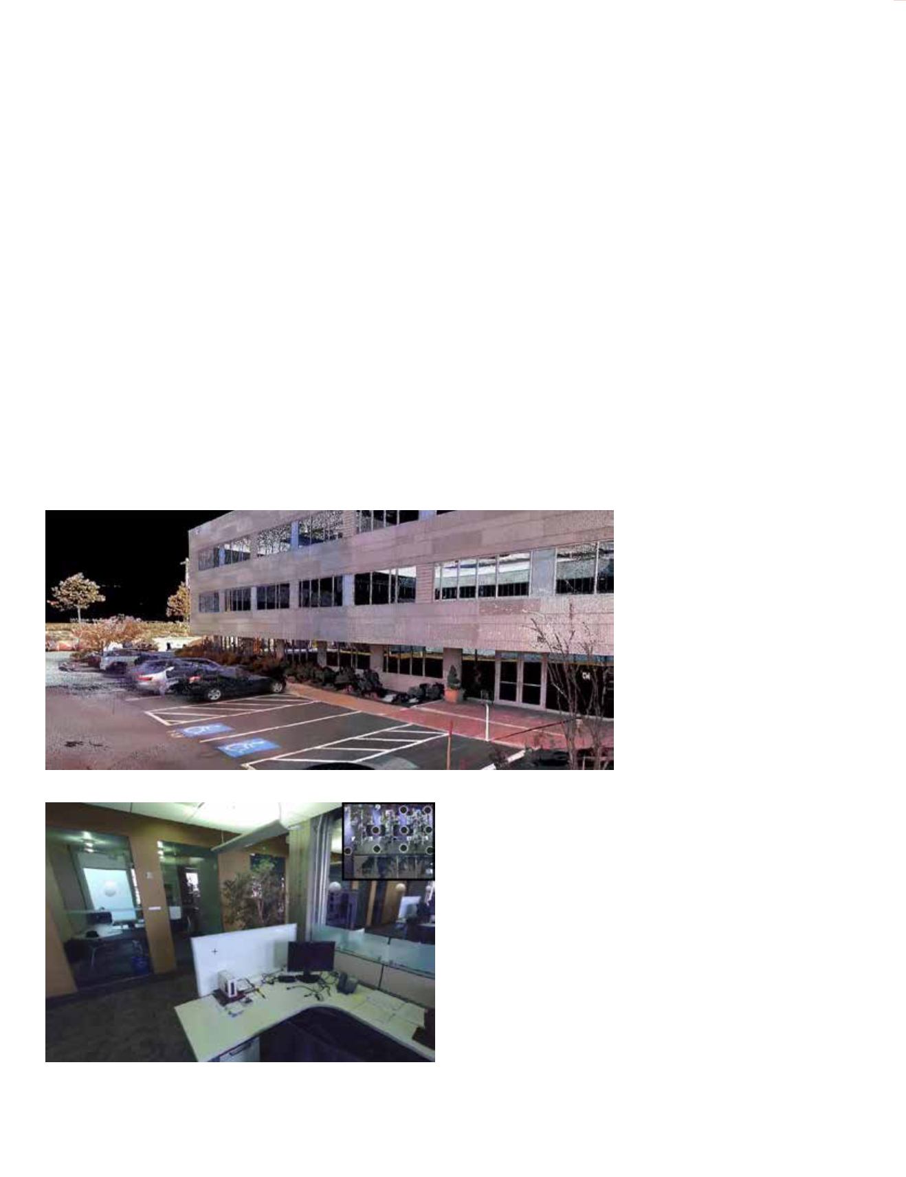
the photo capture of the campus, terrestrial LiDAR scans are
conducted of the perimeter of each building as seen in Figure 3.
For the interiors of the buildings, the team has decided to use
terrestrial LiDAR capture with simultaneous panoramic photo
acquisition. In doing this the SSM has provided his corporation
with a natural looking color view of the interior along with being
able to make centimeter to millimeter measurements from the
point cloud without ever touching a tape measure. Figure 4
shows the merging of these multiple interior terrestrial LiDAR
scans. For ease of review the IT team will select a hot-linked
icon from the inset floor plan. This will pan the view to the
corresponding floating sphere in the main view giving the end
user a perspective view of the LiDAR cloud from that point of
reference. One of the key features with Autodesk ReCap is that
when new features (fire extinguishers, office furniture, new
construction, etc.) are added to the buildings then that feature
can be digitally registered to the baseline 3D model.
As we move back to the story, SWAT arrives at the scene
and are met by the corporation’s SSM who provides the tactical
commander withAutodesk 360mobile viewing files and software
for the tactical team’s tablets and for laptops in the command
center. As the tactical team reviews approach scenarios in the
command center, they are able to see a nadir view (similar to
looking at a floor plan) of the entire
campus. There are icons at each
building on the nadir map that
reference exterior and interior
3D reality captures. By selecting
an icon, the commander can see
a panoramic realistic view of the
point cloud. This will provide the
commander and his team with a
quick and clear understanding of
the campus and its facilities.
With the use of the interior
LiDAR scans the tactical team
can measure and determine exact
distances for ingress to the building
and movement from floor to floor.
Reality Capture provides a valuable
asset to the safety of first responders and increases their ability to
save lives. They can conduct a virtual “walk-through” to see what
is on the other side of the door for a room that has become the
focal point in ending the event.
I spoke with Eugene Liscio, President of the International
Association of Forensic & Security Metrology (IAFSM), about
new research being conducted at the University of Stuttgart,
Germany to train
first responders. There is development in
the use of digital light tables that correlate with interactive 3D
projection displays. The light table shows a floor plan view of
the room (see figure 5).
As the trainer moves the figures on the light table, their
positions change within the Virtual 3D LiDAR rendering of
the room on the active 3D projection system (see figure 6). The
blue and green lines show lines of sight based on the location
of the figures on the light table.
Figure 3. 3D Reality Capture using a LiDAR sensor.
Figure 4. 3D Terrestrial LiDAR Reality Capture of the
interior of a building on the corporate campus.


