PHOTOGRAMMETRIC ENGINEERING & REMOTE SENSING
April 2014
293
on a variety of platforms (desktop computers, tablet devices,
smartphones, etc.) are needed (Beaudette and O’Geen, 2010;
Beaudette and O’Geen, 2009). Application of these technolo-
gies is critical for agronomic and environmental assessments
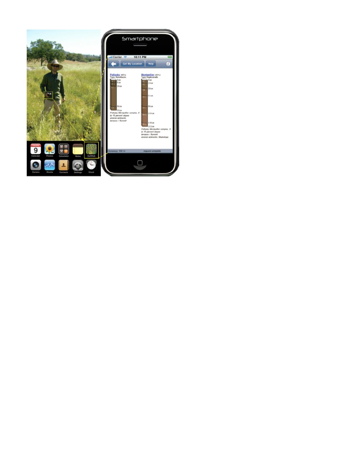
in rural and urban areas from local to global scales. (Plate 5).
Summary
We encourage our community to advance understanding
of these important imaging and geospatial technologies
for soil investigations. We need to strengthen educational,
outreach, and professional certification programs to ensure
informed and ethical applications of emergent sensor ca-
pabilities and knowledge-based systems. Lastly, we must
serve as effective advocates of advanced sensor develop-
ment, standardized processing and modeling of soil data
and environmental co-variates, and appropriate integration
of soil information for effective assessment and monitoring
of environmental impacts and societal decision making.
References
Barnes, E.M., K.A. Sudduth, J.W. Hummel, S.M. Lesch, D.L.
Corwin, C. Yang, C.S.T. Daughtry, and W.C. Bausch,
2003. Remote- and ground-based sensor techniques to
map soil properties,
Photogrammetric Engineering and
Remote Sensing,
69:619–630.
Baumgardner, M.F., L.F. Silva, L.L. Biehl, and E.R. Stoner,
1985. Re ectance properties of soils,
Advances in Agron-
omy,
38:1–44.
Beaudette, D.E. and T.T. O’Geen, 2010. An iphone application
for on-demand access to digital soil survey information,
Soil Sci. Soc. Am. Journal,
74:1–3.
Beaudette, D.E. and A.T. O’Geen, 2009. Soil-Web: An online
soil survey for California, Arizona, and Nevada,
Comput-
ers & Geosciences,
35:2119–2128.
Boettinger, J.L., D.W. Howell, A.C. Moore, A.E. Hartemink,
and S. Kienast-Brown, 2010. Digital soil mapping: bridg-
ing research, environmental application, and operation.
Progress in Soil Science 2, Springer Science+Business
Media B.V., Dordrecht.
Bowers, S.A., and R.J. Hanks, 1965. Reflection of radiant en-
ergy from soils,
Soil Science,
2:130–138.
Brown, M.E., V. Escobar, S. Moran, D. Entekhabi, P.E.
O’Neill, E.G. Njoku, B. Doorn, and J.K. Entin, 2013.
NASA’s soil moisture active passive (SMAP) mission and
opportunities for applications users,
Bulletin Am. Meteo-
rological Soc.,
94:1125–1128.
Buckhannan, W. H., 1939. Technique and use of aerial photo-
graphs for soil mapping and reproduction of field maps,
Soil Science Society of America Proceedings,
21: 382–386.
Bushnell, T.M., 1932. A new technique in soil mapping,
Amer-
ican Soil Survey Association Bulletin,
13:74–81.
Dandois, J.P. and E.C. Ellis, 2013. High spatial resolution
three-dimensional mapping of vegetation spectral dy-
namics using computer vision,
Remote Sensing of Envi-
ronment
, 136:259–276.
Daniels, R.B., S.W. Buol, H.J. Kleiss, and C.A. Ditzler, 1999.
Soil Systems in North Carolina, Technical Bulletin #314,
Dept. Soil Science, North Carolina State University, Ra-
leigh, NC.
Entekhabi, D., E, Njoku, P. O’Neill, K. Kellogg, etc., 2010.
The Soil Moisture Active Passive (SMAP) Mission,
Pro-
ceedings of the IEEE,
98:704–716.
Grunwald, S., J.A. Thompson, and J.L. Boettinger, 2011.
Digital soil mapping and modeling at continental scales
– finding solutions for global issues,
Soil Sci. Soc. Am. J
.,
75(4):1201–1213.
Herrick, J.E., K.C. Urama, J.W. Karl, J. Boos, M.V. Johnson,
K.D. Shepherd, J. Hempel, B.T. Bestelmeyer, J. Da-
vies, J.L. Guerra, C. Kosnik, D.W. Kimiti, A.L. Ekai, K.
Muller, L. Norfleet, N. Ozor, T. Reinsch, J. Sarukhan,
and L.T. West, 2013. The global Land-Potential Knowl-
edge System (LandPKS): Supporting evidence-based,
site-specific land use and management through cloud
computing, mobile applications, and crowdsourcing,
J.
Soil and Water Conservation,
68:5A-12A.
Jenny, H., 1941. Factors of Soil Formation: A System of
Quantitative Pedology, McGraw Hill Book Company,
New York, NY, 281 pp.
Laliberte, A.S., J.E. Herrick, A. Rango, and C. Winters, 2010.
Acquisition, orthorectification, and object-based classi-
fication of unmanned aerial vehicle (UAV) imagery for
rangeland monitoring,
Photogrammetric Eng & Remote
Sensing,
76:661–672.
McBratney, A.B., M.L. Mendonsa-Santos, and B. Minasny,
2003. On digital soil mapping,
Geoderma,
117:3-52.
Plate 5
. US SoilWeb, enabled using mobile phone apps,
allows for wide utilization of soil data in the field by scien-
tists and practitioners.


