1008
November 2014
PHOTOGRAMMETRIC ENGINEERING & REMOTE SENSING
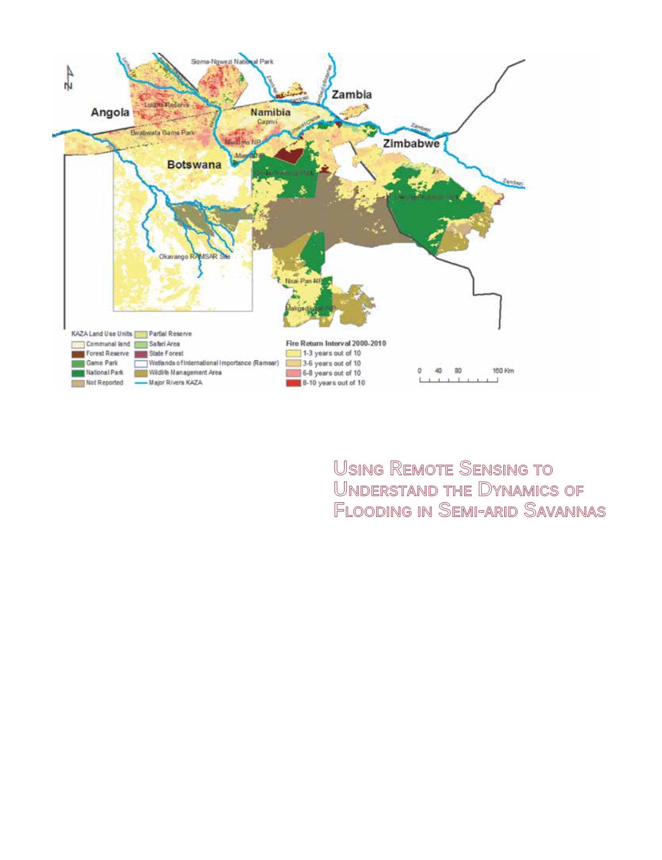
in fire occurrences irrespective of expressed fire policies and
management regimes (Pricope and Binford, 2012). This FRI
was created using MODIS Burned Area Product data (MO-
D45A1: 2000-2010) for the larger area of central KAZA to as-
sess annual fire patterns in protected areas (Figure 2).
Our analysis of the burned area product for the protect-
ed areas of central KAZA reveals that between 15,000 and
35,000 km
2
of these ecosystems burns on an annual basis, de-
pending on the climatologic conditions, fuel load availability
and condition, ignition and other factors (Figure 2). The FRI
we calculated shows that parts of the two protected areas in
Angola and Zambia experience high fire recurrence intervals
for the last decade ranging from 6 to 10 years out of 10 years
in approximately 30 to 40% of their total area. Mudumu Na-
tional Park in Namibia also experiences very high fire recur-
rence intervals for more than 50% of its total area, followed
by some communal areas in the Caprivi. This analysis shows
that fire frequencies have increased across all land use cate-
gories of Eastern Caprivi and northeastern Botswana during
the last decade, with the most significant increases occurring
in September irrespective of the fire management policy of
each country. This may indicate that the underlying cause for
the changes documented can be attributed to climatic changes
and variability.
U
sing
R
emote
S
ensing
to
U
nderstand
the
D
ynamics of
F
looding
in
S
emi
-
arid
S
avannas
The Chobe River Basin is a tributary of the Zambezi River
characterized by an unusual flow regime consisting of variable
flood pulses at different times of the year from rivers with
headwaters in the tropical regions of Angola and Zambia,
namely the Kwando and Zambezi Rivers (Figure 3). This
unusual flow regime, previously relatively undocumented
and explained below, is mainly the result of geo-tectonic
modifications through time and is currently reinforced by the
presence of relatively active fault lines in the region, such
as the Linyanti Fault, which is the main geologic control
for the present-day location of the Chobe-Linyanti channel
(Gumbricht et al., 2001). Significant vegetation changes have
occurred in this region over the last thirty years, possibly
caused by significant increases in wildlife populations,
decreases in rainfall and river inundation extent, and
increasing human and cattle populations (Rutina et al., 2005)
(Figure 4). Human settlements and their traditional way
of life are impacted by these changes and displacements of
population are becoming a current occurrence in the region.
Wetlands and seasonally-inundated floodplains in semi-
arid environments play major roles in the regional and global
Figure 2. Map of central Kavango-Zambezi Transfrontier Conservation Area (KAZA) showing the spatial extent of a fire recurrence index (FRI)
calculated using monthly MODIS Burned Area data from 2000 to 2010 for all land use categories in the region. The scores which make up the
FRI represent the number of years an area is burned aggregated from monthly spatial extents of burning
(Source: Pricope and Binford, 2012).


