PHOTOGRAMMETRIC ENGINEERING & REMOTE SENSING
November 2016
829
•
Express Server Tomcat Service.
The
Tomcat service runs the Express Serv-
er web applications, including Express
Server Manager for managing Express
Server and ExpressZip for image export.
•
JPIP Service.
The JPIP service is
an optional service that you can add
during the Express Server installation.
The JPIP service processes requests
from JPIP clients.
I
mage
S
erver
The image server is the core of the Express
Server installation and processes all image
requests. When users connect to Express
Server, the image server receives the image
request and renders the image.
By default, Express Server delivers extract-
ed scenes as JPEG images. Other options for
final delivery format are PNG (.png), GIF
(.gif), TIFF (.tif, .tiff), Bitmap (.bmp), and
MrSID Generation 2, 3, or 4 (.sid).
Express Server can deliver lidar point clouds in
MrSID, LAS, or LAZ format. MrSID and LAZ files offer
compression; LAS is the uncompressed equivalent of LAZ.
I
mage
D
ata
The source image data distributed by Express Server is
stored on a local or network file system. Express Server
supports MrSID, JPEG 2000, and NITF raster imagery,
along with MrSID, LAS, and LAZ lidar point clouds.
S
upported
I
mage
F
ormats
MrSID and JPEG 2000 are both wavelet-based formats
that facilitate the efficiencies of raster data storage and
distribution. Because their wavelet-based algorithms
naturally and automatically result in multiple resolu-
tions of an image within the compressed image file it-
self—from the full resolution image down to a low-reso-
lution thumbnail—both formats provide the high image
quality required by geospatial professionals yet obviate
costly and time-consuming image pyramiding.
MrSID images are identified by generation and may
be MrSID Generation 2 (MG2), MrSID Generation 3
(MG3™) or MrSID Generation 4 (MG4™). There are
important differences among them. MG2, the oldest ver-
sion, has a 2GB file size limit and does not support loss-
less compression. MG3 introduced support for lossless
compression and a number of other features including
reprojection, color balancing, despeckling and encoding
areas of interest, and removed the 2GB size limit.
MG4 is the most recent evolution of the MrSID format.
In addition to mosaicking datasets together, color bal-
ancing raster imagery, and manipulating data in oth-
er ways as do MG2 and MG3, MG4 enables geospatial
professionals to losslessly compress 3-banded and mul-
tispectral (including hyperspectral) geospatial data so
that they can make full use of the most up-to-date im-
agery. MG4 also introduced support for alpha bands,
which remove the problem of speckling in the transpar-
ency areas of mosaics.
Table 1 illustrates the differences between versions of
the MrSID format and JPEG 2000.
V
isualizing
I
mage
R
equests
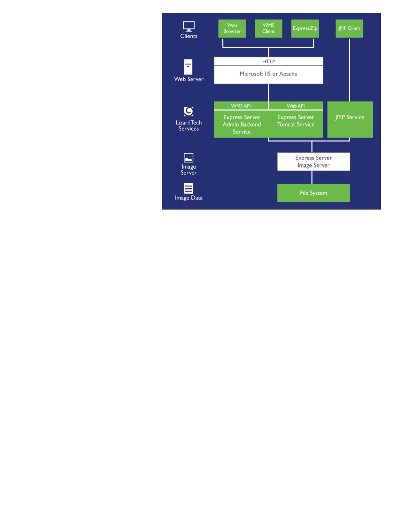
The diagram below illustrates the round trip of an im-
age request to Express Server and return of the image
to the client. Once a client image request is received
by the web server, the request is recognized as belong-
ing to one of the protocols supported by Express Server.
The Express Server engine then:
•
determines what reader to use
•
locates and opens the image after consulting the
various caches
•
extracts the requested scene based on requested
parameters such as level (resolution), width and
height, and geospatial coordinates
•
engages an image writer based on the specified out-
put format
•
delivers the image
Figure 1: Express Server Architecture.


