792
December 2017
PHOTOGRAMMETRIC ENGINEERING & REMOTE SENSING
Be a part of ASPRS Social Media:
PHOTOGRAMMETRIC ENGINEERING
& REMOTE SENSING
J
ournal
S
taff
Publisher ASPRS
Editor-In-Chief Alper Yilmaz
Technical Editor Michael S. Renslow
Assistant Editor Jie Shan
Assistant Director — Publications Rae Kelley
Electronic Publications Manager/Graphic Artist Matthew Austin
Photogrammetric Engineering & Remote Sensing
is the official journal of the
American Society for Photogrammetry and Remote Sensing. It is devoted to the
exchange of ideas and information about the applications of photogrammetry,
remote sensing, and geographic information systems. The technical activities of
the Society are conducted through the following Technical Divisions: Geographic
Information Systems, Photogrammetric Applications, Lidar, Primary Data
Acquisition, Professional Practice, and Remote Sensing Applications. Additional
information on the functioning of the Technical Divisions and the Society can
be found in the Yearbook issue of
PE&RS
.
Correspondence relating to all business and editorial matters pertaining to this
and other Society publications should be directed to the American Society for
Photogrammetry and Remote Sensing, 425 Barlow Place, Suite 210, Bethesda,
Maryland 20814-2144, including inquiries, memberships, subscriptions, changes
in address, manuscripts for publication, advertising, back issues, and publica-
tions. The telephone number of the Society Headquarters is 301-493-0290; the
fax number is 301-493-0208; web address is
.
PE&RS
.
PE&RS
(ISSN0099-1112) is published monthly by the American
Society for Photogrammetry and Remote Sensing, 5410 Grosvenor Lane, Suite
210, Bethesda, Maryland 20814-2144. Periodicals postage paid at Bethesda,
Maryland and at additional mailing offices.
SUBSCRIPTION
.
For the 2017 subscription year, ASPRS is offering two options
to our
PE&RS
subscribers — an e-Subscription and the print edition. E-sub-
scribers can plus-up their subscriptions with printed copies for a small addi-
tional charge. Print subscriptions are on a calendar-year basis that runs from
January through December. Electronic subscriptions run for twelve months on
an anniversary basis. We recommend that customers who choose both e-Sub-
scription and print (e-Subscription + Print) renew on a calendar-year basis.
The new electronic subscription includes access to ten years’ of digital back
issues of
PE&RS
for online subscribers through the same portal at no addi-
tional charge. Please see the Frequently Asked Questions about our journal
subscriptions.
The rate of the e-Subscription (digital) Site License Only for USA and For-
eign: $899.00; e-Subscription (digital) Site License Only for Canada*: $944.00;
Special Offers
: e-Subscription (digital) Plus Print for the USA: $1,160.00;
e-Subscription (digital) Plus Print Canada*: $1,224.00; e-Subscription (digital)
Plus Print Outside of the USA: $1,175.00; Printed-Subscription Only for USA:
$959.00; Printed-Subscription Only for Canada*: $1,013.00; Printed-Subscrip-
tion Only for Other Foreign: $974.00. *Note: e-Subscription/Printed-Subscrip-
tion Only/e-Subscription Plus Print for Canada include 5% of the total amount
for Canada’s Goods and Services Tax (GST #135123065).
POSTMASTER
.
Send address changes to
PE&RS
, ASPRS Headquarters, 425 Bar-
low Place, Suite 210, Bethesda, Maryland 20814-2144. CDN CPM #(40020812)
MEMBERSHIP
.
Membership is open to any person actively engaged in the prac-
tice of photogrammetry, photointerpretation, remote sensing and geographic
information systems; or who by means of education or profession is interested
in the application or development of these arts and sciences. Membership is
for one year, with renewal based on the anniversary date of the month joined.
Membership Dues include a 12-month electronic subscription to
PE&RS
. Or
you can receive the print copy of
PE&RS
Journal which is available to all mem-
ber types for an additional fee of $60.00 USA and or $75.00 for international
shipping. Subscription is part of membership benefits and cannot be deducted
from annual dues. Dues for ASPRS Members outside of the U.S. will now be the
same as for members residing in the U.S. Annual dues for Regular members
(Active Member) is $150; for Student members it is $50 for USA and Canada;
$60 for Other Foreign. A tax of 5% for Canada’s Goods and Service Tax (GST
#135123065) is applied to all members residing in Canada.
COPYRIGHT 2017
. Copyright by the American Society for Photogrammetry and
Remote Sensing. Reproduction of this issue or any part thereof (except short
quotations for use in preparing technical and scientific papers) may be made
only after obtaining the specific approval of the Managing Editor. The Society
is not responsible for any statements made or opinions expressed in technical
papers, advertisements, or other portions of this publication. Printed in the
United States of America.
PERMISSION TO PHOTOCOPY
.
The appearance of the code at the bottom of the
first page of an article in this journal indicates the copyright owner’s consent
that copies of the article may be made for personal or internal use or for the
personal or internal use of specific clients. This consent is given on the condi-
tion, however, that the copier pay the stated per copy fee of $3.00 through the
Copyright Clearance Center, Inc., 222 Rosewood Drive, Danvers, Massachu-
setts 01923, for copying beyond that permitted by Sections 107 or 108 of the
U.S. Copyright Law. This consent does not extend to other kinds of copying,
such as copying for general distribution, for advertising or promotional purpos-
es, for creating new collective works, or for resale.
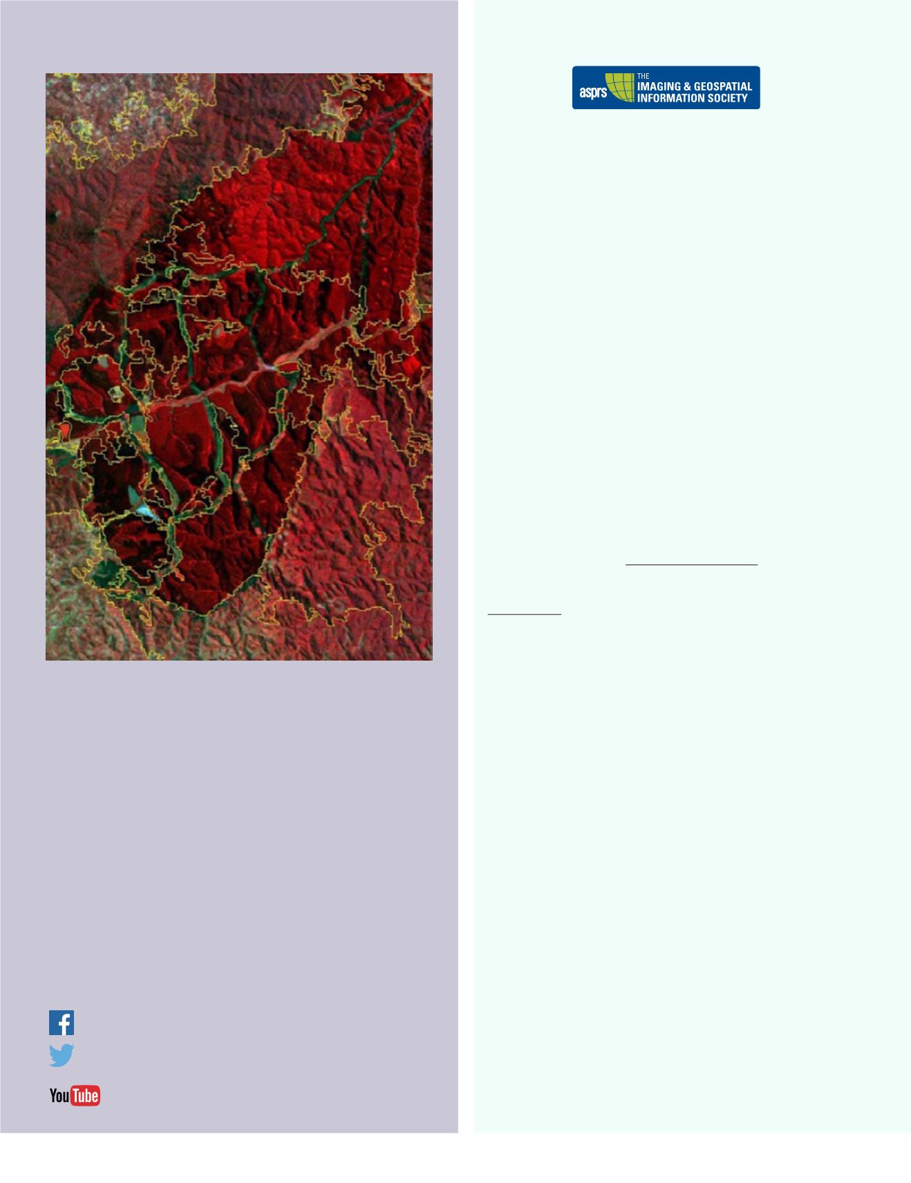
The cover is a 2010 Landsat Thematic Mapper image subset for a portion of Mala-
wi from a national land use and land cover change mapping activity by the United
Nations Food and Agricultural Organization for climate change and carbon track-
ing under the Intergovernmental Panel for Climate Change guidelines. The specific
process used an object based image analysis approach to divide the country into
about 230,000 segments which were then each labeled by Malawian nationals. The
Malawi mapping activity is an interesting combination of machine processing, seg-
mentation, visual interpretation, and the assignment of class types. This example is
from the Highlight Article in this issue by Haack and Ryerson on ‘Training for Remote
Sensing Image Interpretation’. The authors argue that visual interpretation is a very
common and often necessary part of information extraction from remote sensing
data, even when machine methods are used. This is especially so for operational
projects. They conclude that the remote sensing community does not always suffi-
ciently provide visual interpretation capabilities to the work force.


