656
October 2017
PHOTOGRAMMETRIC ENGINEERING & REMOTE SENSING
Be a part of ASPRS Social Media:
PHOTOGRAMMETRIC ENGINEERING
& REMOTE SENSING
J
ournal
S
taff
Publisher ASPRS
Editor-In-Chief Alper Yilmaz
Technical Editor Michael S. Renslow
Assistant Editor Jie Shan
Assistant Director — Publications Rae Kelley
Electronic Publications Manager/Graphic Artist Matthew Austin
Photogrammetric Engineering & Remote Sensing
is the official journal of the
American Society for Photogrammetry and Remote Sensing. It is devoted to the
exchange of ideas and information about the applications of photogrammetry,
remote sensing, and geographic information systems. The technical activities of
the Society are conducted through the following Technical Divisions: Geographic
Information Systems, Photogrammetric Applications, Lidar, Primary Data
Acquisition, Professional Practice, and Remote Sensing Applications. Additional
information on the functioning of the Technical Divisions and the Society can
be found in the Yearbook issue of
PE&RS
.
Correspondence relating to all business and editorial matters pertaining to this
and other Society publications should be directed to the American Society for
Photogrammetry and Remote Sensing, 425 Barlow Place, Suite 210, Bethesda,
Maryland 20814-2144, including inquiries, memberships, subscriptions, changes
in address, manuscripts for publication, advertising, back issues, and publica-
tions. The telephone number of the Society Headquarters is 301-493-0290; the
fax number is 301-493-0208; web address is
.
PE&RS
.
PE&RS
(ISSN0099-1112) is published monthly by the American
Society for Photogrammetry and Remote Sensing, 5410 Grosvenor Lane, Suite
210, Bethesda, Maryland 20814-2144. Periodicals postage paid at Bethesda,
Maryland and at additional mailing offices.
SUBSCRIPTION
.
For the 2017 subscription year, ASPRS is offering two options
to our
PE&RS
subscribers — an e-Subscription and the print edition. E-sub-
scribers can plus-up their subscriptions with printed copies for a small addi-
tional charge. Print subscriptions are on a calendar-year basis that runs from
January through December. Electronic subscriptions run for twelve months on
an anniversary basis. We recommend that customers who choose both e-Sub-
scription and print (e-Subscription + Print) renew on a calendar-year basis.
The new electronic subscription includes access to ten years’ of digital back
issues of
PE&RS
for online subscribers through the same portal at no addi-
tional charge. Please see the Frequently Asked Questions about our journal
subscriptions.
The rate of the e-Subscription (digital) Site License Only for USA and For-
eign: $899.00; e-Subscription (digital) Site License Only for Canada*: $944.00;
Special Offers
: e-Subscription (digital) Plus Print for the USA: $1,160.00;
e-Subscription (digital) Plus Print Canada*: $1,224.00; e-Subscription (digital)
Plus Print Outside of the USA: $1,175.00; Printed-Subscription Only for USA:
$959.00; Printed-Subscription Only for Canada*: $1,013.00; Printed-Subscrip-
tion Only for Other Foreign: $974.00. *Note: e-Subscription/Printed-Subscrip-
tion Only/e-Subscription Plus Print for Canada include 5% of the total amount
for Canada’s Goods and Services Tax (GST #135123065).
POSTMASTER
.
Send address changes to
PE&RS
, ASPRS Headquarters, 425 Bar-
low Place, Suite 210, Bethesda, Maryland 20814-2144. CDN CPM #(40020812)
MEMBERSHIP
.
Membership is open to any person actively engaged in the prac-
tice of photogrammetry, photointerpretation, remote sensing and geographic
information systems; or who by means of education or profession is interested
in the application or development of these arts and sciences. Membership is
for one year, with renewal based on the anniversary date of the month joined.
Membership Dues include a 12-month electronic subscription to
PE&RS
. Or
you can receive the print copy of
PE&RS
Journal which is available to all mem-
ber types for an additional fee of $60.00 USA and or $75.00 for international
shipping. Subscription is part of membership benefits and cannot be deducted
from annual dues. Dues for ASPRS Members outside of the U.S. will now be the
same as for members residing in the U.S. Annual dues for Regular members
(Active Member) is $150; for Student members it is $50 for USA and Canada;
$60 for Other Foreign. A tax of 5% for Canada’s Goods and Service Tax (GST
#135123065) is applied to all members residing in Canada.
COPYRIGHT 2017
. Copyright by the American Society for Photogrammetry and
Remote Sensing. Reproduction of this issue or any part thereof (except short
quotations for use in preparing technical and scientific papers) may be made
only after obtaining the specific approval of the Managing Editor. The Society
is not responsible for any statements made or opinions expressed in technical
papers, advertisements, or other portions of this publication. Printed in the
United States of America.
PERMISSION TO PHOTOCOPY
.
The appearance of the code at the bottom of the
first page of an article in this journal indicates the copyright owner’s consent
that copies of the article may be made for personal or internal use or for the
personal or internal use of specific clients. This consent is given on the condi-
tion, however, that the copier pay the stated per copy fee of $3.00 through the
Copyright Clearance Center, Inc., 222 Rosewood Drive, Danvers, Massachu-
setts 01923, for copying beyond that permitted by Sections 107 or 108 of the
U.S. Copyright Law. This consent does not extend to other kinds of copying,
such as copying for general distribution, for advertising or promotional purpos-
es, for creating new collective works, or for resale.
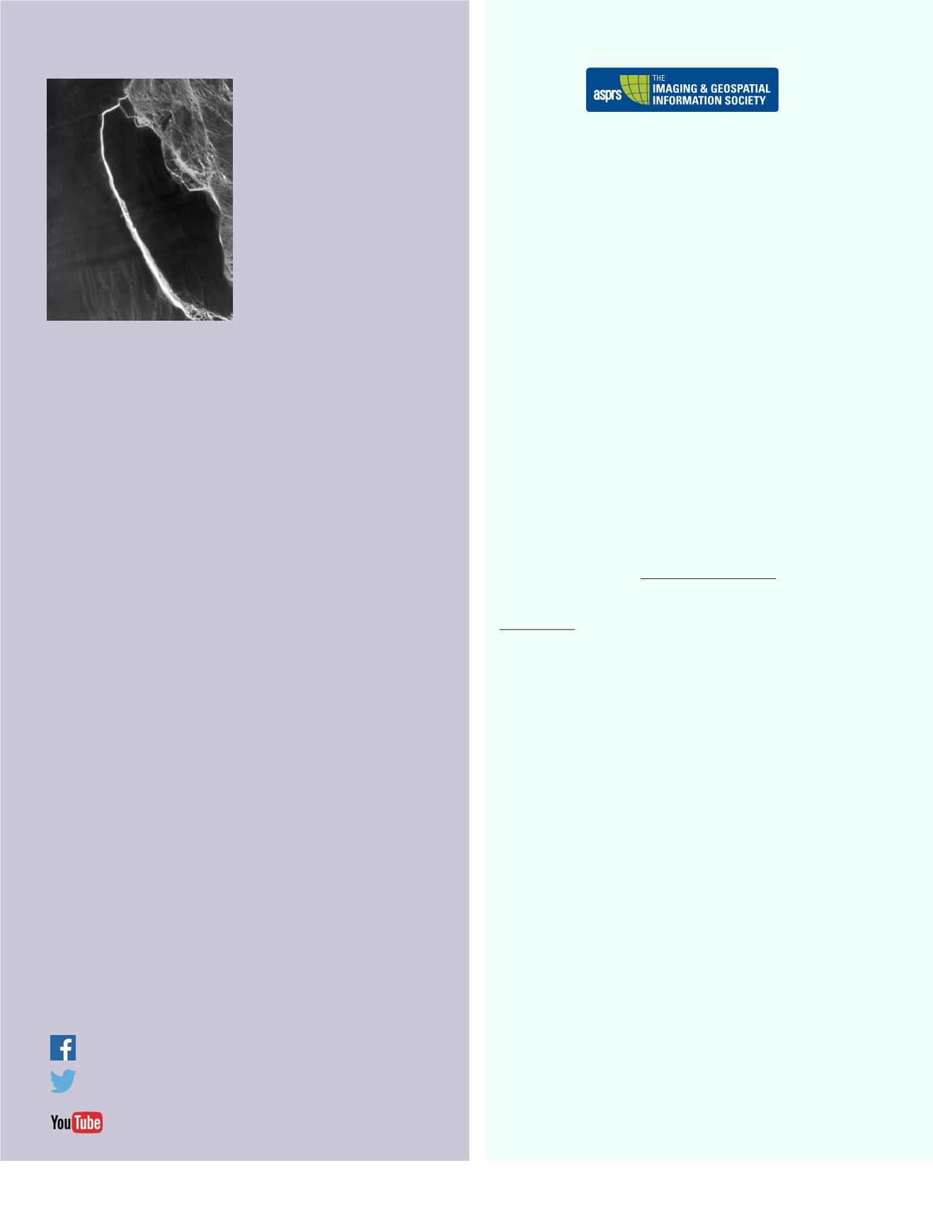
When a massive iceberg first broke away
from Antarctica’s Larsen C ice shelf some-
time between July 10-12, 2017, scientists
knew it would eventually start breaking
apart. That’s the normal life cycle of a
drifting iceberg, which is at the mercy of
the ocean’s battering currents, tides, and
winds. Already those forces have turned
A-68 into two named bergs, A-68A and
A-68B, as well as a handful of pieces too
small to be named by the U.S. National Ice
Center.
In the two weeks following the initial
break, satellite imagery has documented
the iceberg’s motion. The southern end ap-
pears to have slammed into a mix of float-
ing ice above Gipps Ice Rise—the bump of snow- and ice-covered bedrock visible in
the lower right of the image. Then the berg rebounded and its northern end swung
back toward the just opened rift. The resulting impact caused both the berg’s north
end and the ice shelf to fracture.
“The back-and-forth movement of A-68 looks akin to maneuvering a parallel-parked
car out of a tight parking space—like an Austin Powers three-point turn,” said Chris-
topher Shuman, a cryospheric scientist at NASA’s Goddard Space Flight Center and
the University of Maryland, Baltimore County.
The fractured berg and shelf are visible in this image, acquired on July 21, 2017, by
the Thermal Infrared Sensor (TIRS) on the Landsat 8 satellite. The false-color view
shows the relative warmth or coolness across the region. White indicates where
the ice or water surface is warmest, most notably in the widening strip of mélange
between the main iceberg and the remaining ice shelf. Dark grays and blacks are
the coldest areas of ice.
So far, the calving and fracturing has taken place under the dark cover of polar night
during Antarctica’s austral winter. That makes thermal imagery from satellites a
critical tool for “seeing” the action. Adrian Luckman of the UK-based Project MI-
DAS first saw the berg break away in thermal data from the Moderate Resolution
Imaging Spectroradiometer (MODIS), before Sentinel radar data became available
later on July 12.
The thermal view above shows a remarkable amount of detail. The bright signature
of relatively warm ocean water appears around A-68B, which broke off sometime
between late July 13 and early July 14. More subtle fractures north of A-68B are
visible on the shelf; these pieces will eventually break free and move out to sea with
the rest of the ice.
All of the ice pieces large and small are subject to the water currents of the Weddell
Gyre and the strong weather systems that can whip up blinding snow and blanket
the region in clouds for many days at a time. This same ocean circulation that will
eventually move the bergs northward toward South Georgia Island.
NASA Earth Observatory images by Jesse Allen, using Landsat data from the U.S.
Geological Survey. Story by Kathryn Hansen.
This image record originally appeared on the Earth Observatory.
To see the full image, visit,


