PHOTOGRAMMETRIC ENGINEERING & REMOTE SENSING
November 2019
783
GIS
&
Tips Tricks
By Al Karlin, Ph.D.,CMS, GISP
files, including LDPyramid.exe and LPScanInfo.exe, which
will be demonstrated in this tip. These executables can
be called from the command-line (DOS Prompt) or from
other scripts (think: Python) or programs. Below is a
demonstration on how to use these from the command-line.
For LP360 v2018.2.59 and higher, the command-line
executables are located in the
C:\Program Files (x86)\Common
Files\LP360
folder as, LDPyramid.exe (to construct the .QVR
files) and LPScanInfo.exe (to construct the .SCAN files).
To execute the commands for building the .QVR files and/
or the .SCAN files:
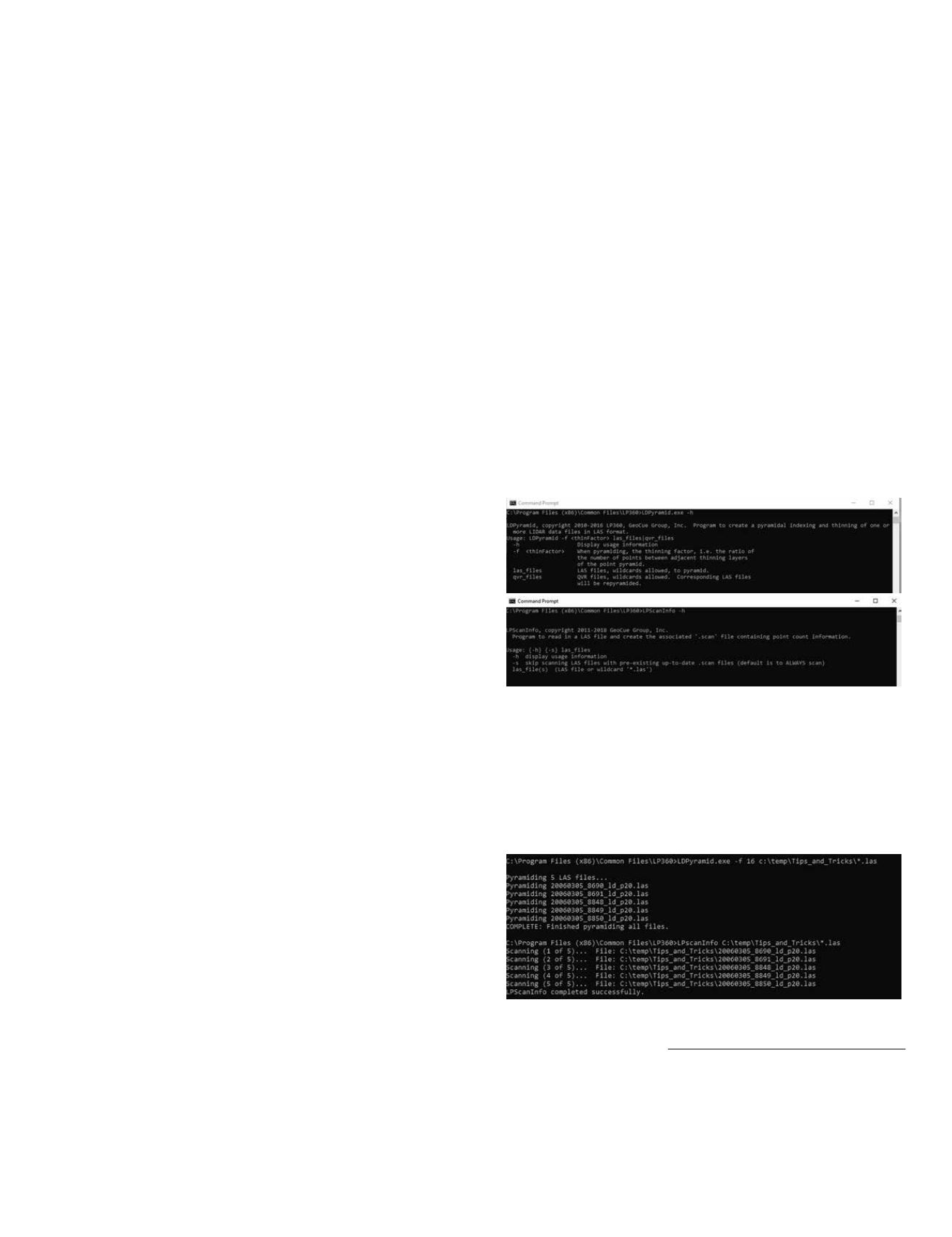
1. Open a DOS prompt (click: Windows|run|and type “CMD”
or Windows|Windows System|Command Prompt),
2. Navigate to the
C:\Program Files (x86)\Common Files\
LP360
directory,
3. At the DOS prompt, type “
LDPyramid.exe –f 16
(full path
to LAS files)
\*.las
and press “Enter” to build the .QVR
files (do not forget the space between the
–f
and
16
), and
when the DOS prompt returns,
4. Type “
LPScanInfo.exe –s
(full path to LAS files)
\*.las
and press “Enter” to build the .SCAN files.
While in the
C:\Program Files (x86)\Common Files\LP360
directory, program “Help” can be retrieved by typing (at the
DOS prompt):
LDPyamid.exe –h or LPScanInfo –h
NOTE: If you just type in either LDPyramid.exe (or
LPScanInfo.exe) without the –h switch, you will get
an error, which you can ignore, along with the “Help”
information, as above.
As an example, I ran the executables on 5 .LAS files that I
download from the NOAA Coastal DataViewer (
noaa.gov/dataviewer; I’ll write a tip about this lidar source
in a future column) and stored in my “C:\Temp\Tips_and_
Tricks” directory with:
continued on page
The Old DOS Prompt is Still Your Friend
In the early 1990’s, with the introduction of Microsoft
Windows’ Graphical User Interface (GUI), the slow but
steady disappearance of the old, familiar DOS prompt, C:>,
began. With the exception of RapidLasso’s LASTools™ (and
even LASTools™ are accessible through an included GUI),
most, if not all major lidar, GIS, and remote sensing software
packages are accessed through a Microsoft “ribbon-line” GUI.
Users have become so accustomed to the GUI that we forget
that there are some routines that are easier, faster, and more
efficient to access through the old DOS prompt.
GeoCue’s LP360 tools, both the 64-bit “stand-alone” and
the 32-bit LP360 for ArcGIS, are generally accessed through
a GUI. The first time a user constructs an LP360 LAS Layer
from LAS files previously unopened in LP360 to facilitate
fast rendering, some preliminary processing is necessary.
For the rendering, LP360 relies on pyramid files called .QVR
files, based on a user-specified thinning factor. The higher the
thinning factor, the fewer levels there will be in the pyramid
file. Therefore, for very large, dense USGS QL1 .LAS files,
a larger (higher) thinning factor will be used. For example,
with a thinning factor of 16 (recommended for QL1 data files),
the first pyramid level will contain every 16th point of the
full resolution. The second level will contain every 16th point
of the first level, and so on. In contrast, for USGS QL3 LAS
data, a thinning factor of two or four would be appropriate.
The data-loader in the LP360 GUI does not prompt the
user to build the .QVR files if the files do not exist, but the
LP360 renderer will frequently fail to display the entire file
at full resolution resulting from display card memory issues
if the pyramid files do not. So, it is a good idea to check the
directory containing the .LAS files and determine whether
the .QVR files exist. The files will have the same name as
the .LAS files, but with the .QVR extension. If the .QVR files
do not exist, the LP360 data-loader GUI provides a checkbox
(see LP360 user manual) to construct the .QVR files with
a user-specified thinning factor. In general, on an Intel i7-
level (or Xenon-level) computer with 8 gigabytes (GB) of
RAM, it will take about one to four minutes per .LAS file
to generate the .QVR file for a 1GB .LAS file. So for a small
QL1 LiDAR project containing between five and 10 files
(roughly 1GB each), this processing could take between five
and 15 minutes of processing. Larger projects could require
several hours, and are best processed overnight.
GeoCue has recently released the LAS File Analyst tools to
support several U.S. government agency’s needs for LAS file
information. These tools were designed to review, analyze,
and repair some LAS file issues. In order to do so, GeoCue
needed to collect and record LAS file information into
another supporting file, the .SCAN file. Similar to the .QVR
support files, the .SCAN can be constructed through a GUI,
in this case, the Live View GUI (see LP360 user-manual).
Fortunately, GeoCue provides “command line” access to
the pyramiding and scanning executable programs. In fact,
GeoCue provides 15 command-line, accessible executable
Photogrammetric Engineering & Remote Sensing
Vol. 85, No. 11, November 2019, pp. 783, 785.
0099-1112/19/783, 785
© 2019 American Society for
Photogrammetry and Remote Sensing
doi: 10.14358/PERS.85.11.783


