Software Review
[Return to the Software Reviews Index]
IDRISI32
Reviewed by: David R. Green and Stephen D. King
(reprinted from PE&RS November 2000)
|
Product Information Name: Released: Developer: Cost: Distribution: Hardware Requirements: |
Executive
Summary
IDRISI32 (32-bit object-oriented system) is the most recent release of the integrated GIS and Image Processing software package, IDRISI, from Clark Labs, Clark University in the USA. Earlier releases ran under the MS-DOS operating system (Versions 2.4-4.1) and later MS Windows (Versions 1 and 2). It has now been re-written from scratch to accommodate IDRISI’s growing user base and new developments in the geospatial technologies, advances and updates of computer operating systems, and the associated software. In so doing, it has built upon the past, taking into account user requirements for geospatial data input, analysis, display and output. Additions and improvements that have been included are a real-time interface with GPS, improved map composition capabilities, and more advanced functionality to take on-board new developments and growing end-user demands to meet the needs of applications. Links to the industry standard Gstats routines are also included. Features
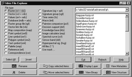
This module provides tools to input, edit, create, and update datafiles, with links to their add-on digitizing software, CartaLinx (a 32 bit spatial data builder), and the relational database manager (RDBM). Data Reformat has tools to convert, project, resample, subset and generalise image and vector datafiles. This tool provides users with a very simple interface to manage their data files (IDRISI File Explorer – Figure 1) and to document them (Metadata – Figure 2), as well as the means to reuse old IDRISI files from previous releases, the means and flexibility to import common file formats into the IDRISI work environment e.g. raster and vector: dxfidris; tifidris; mifidris; shapeidris, as well as the opportunity to export files to formats usable by other software.
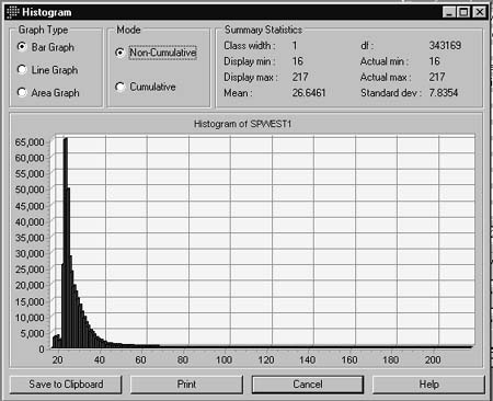
Analysis is the heart of the whole IDRISI32 system offering users a very comprehensive suite of both simple and advanced geospatial data analysis tools for both raster and vector data – in other words a very powerful data handling and analysis toolbox. These include Database Query, Mathematical, Distance and Context Operators, Statistics, Image Processing, Decision Support, Change and Time Series Analysis, and Surface Analysis. Some of the familiar options are Edit, Reclas, Overlay, Crosstab, Assign, Extract, Histo (Figure 3), Area, Profile, Scalar, Transform, Distance, Cost, Buffer, Pathway, Thiessen, Surface, Group, Viewshed, Watershed, Regress, Count, Trend, Autocorr, Random, Resample, Destripe, Stretch, Filter, PCA, Colspace, Vegindex, Tasscap, Fourier, Makesig, Scatter, Piped, MinDist, Cluster, Errmat, Weight, Rank, TIN, Kriging (and Simulation), Slope, Aspect, Hillshade, Contour amongst many others. Interesting though, are the tools such as Pattern (relative richness, diversity etc.), Fuzsig (fuzzy signature extractor), Thermal (Conversion of Landsat TM 6 to blackbody temperatures), softclassifiers such as Belclass (Dempster-Shafer Belief Classification), MCE (Multi-Criteria Classification), TSA (Standardised Principal Components), Spatial Dependence Modeler, and Fractal (Fractal Dimension of a Surface) This is the tool to display the image and map files together with tools such as Symbol Workshop to allow one to tailor the output, to display multi-band imagery (Composite), to visualise image statistics (histo), to put together small time-series of images using Media Viewer, and last but not least to create map output.
Performance Computer Hardware Datasets Operations Documentation The documentation included in the box from Clark Labs included the following manuals:
The text offers useful advice to the end-user about exploratory data analysis, the use of original data in an analysis, information and meaning in the context of digital image processing, and the role of visual interpretation, all of which serves to confirm the thought that has gone into IDRISI32. Particularly good and readable coverage is also given to topics like Fourier Analysis, Georeferencing, and Kriging. The idea of introducing a trick question is also carefully thought out. Clark Labs offer a range of UNITAR Workbooks (only two of the six are currently available for IDRISI32): Change and Time Series Analysis and Applications in Forestry. Online help is also provided through the detailed IDRISI32 Help System, through Technical Support and the Idrisi-L discussion list server. Additional support is provided by the 14 IDRISI Resource Centers around the World, and Clark Labs Educational Programs, and notably for schools by online Teacher Resources. Technical Support Technical support is offered to users for:
Ease of Installation The IDRISI package was installed as per the instructions provided with the software in the Reference Guide using autorun and the setup program, and proved very straightforward. There were no problems installing the software on the machine chosen for this review. Although the Reference Guide details various requirements, no difficulties were experienced. Ease of Use Having not had the opportunity to use the IDRISI software for a little while, we have to say that we are very impressed by this current package of materials, the quality of the accompanying documentation, and the ease with which it is possible to simply get going. Perhaps more importantly, we like being able to see how you can use the software for various different applications; something that it is not always easy to do with all software. Starting the Software Interface
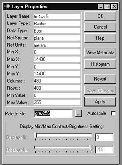
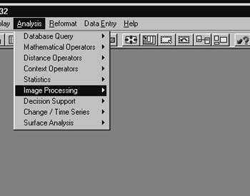 Figure 4 IDRISI is a truly integrated GIS package that includes digital image processing software. On the whole, the IDRISI32 software is very impressive. It is an appealing and affordable piece of GIS “kit” that still has considerable scope for use in an educational/training environment, despite having evolved into a professional-level GIS. However, IDRISI32 must be evaluated on the basis of its ease of use, by means of notable features such as the Layer Properties, Project Environment, the Image Calculator, and the Symbol Workshop (Figures 5-7), its comprehensive breadth of functionality, excellent documentation, and the many avenues of support offered.
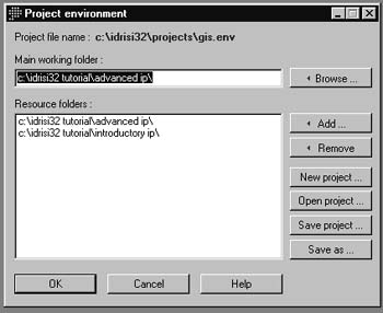 Figure 6 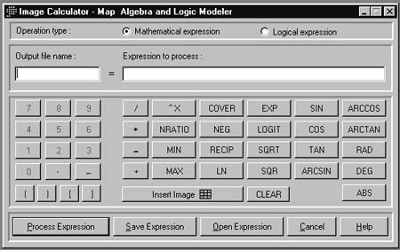
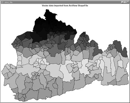
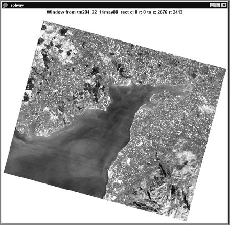
But, it should also be mentioned that IDRISI is perhaps not for the faint-hearted, and, if anything, highlights the complexity of GIS as an analytical toolbox. This is something that is perhaps not clearly recognised by the layman who may have heard that GIS is useful in their work, but does not fully appreciate that GIS is a lot more than just a simple mapping tool! What IDRISI does succeed in showing the end-user though, through its comprehensive approach, is just how powerful and valuable a tool GIS can be for geospatial data exploration, analysis, and visualization to aid us in improving our knowledge and understanding of the real world. This is a highly functional toolbox with considerable application potential. Disadvantages There do not seem to be many real problems except for a few relatively minor things. However, to utilise a number of existing image datasets available to us did seemingly reveal a few potentially annoying problems. For example, the ERDAS Imagine format does not seem to be directly supported yet. However, an ArcView .SHP file (UK Census ward boundaries for the County of Surrey) went straight in with no problems (Figure 8), as did a GeoTIFF (a Landsat TM image of the Solway Firth, UK, originating in ERDAS Imagine (Figure 9)). The export to the .JPG format also worked without any problems. While the IDRISI package is not really any different than many other software packages on the data import/export front, so that all different data formats can be used effortlessly, it has to be said that most desktop software still needs to be able to handle a wide range of data formats more smoothly. Gone are the days where people are willing to experiment with getting the data into the system. Data really needs to go straight into a system with a minimum of effort for the current generation of users.
Reference to the IDRISI discussion list (IDRISI-L) also suggests that people experience similar types of problems when trying to work with their own data, but more often when trying to undertake analyses. These “online discussion lists” for IDRISI users offer a good form of practical support whereby it may perhaps help to identify possible ‘bugs’ in a software version release, or alternatively help someone to prepare and process their GIS and remotely-sensed data. They also probably help in the development of the software product in direct response to specific difficulties experienced by of the end-user due to their expectations. To be fair, this is a problem faced by many people with any current software, especially now with the rapid growth in the breadth of the end-user base and where both theoretical and practical expertise are sometimes limited. No software package, however good, will suit every potential user, nor will it be entirely free from little glitches, and unfortunately, accompanying tutorials and manuals can never cover all the possible tasks that people might want to use the software for. However, having said this, we do think that the IDRISI32 tutorial exercises and documentation provide a very good range of examples that can be used as templates for new applications, and evidence of the wide range of user support suggests that help is always at hand.
Definitions Tutorial sheets Recommendations The fact that IDRISI is still with us after so many years (1986/7 – present) is sheer testimony, we think, to the quality and value of this software in the world of education, research, and practice. Given its affordable cost and the level of support, it offers a very attractive GIS/DIP software package for many people, but goes beyond many others in terms of its analytical functionality and ease of use. By comparison, to the first DOS version of IDRISI, the latest version of IDRISI for MS-Windows is a real revolution for the end-user. While retaining the positive points of earlier versions of IDRISI (both DOS and Windows), it has also taken full advantage of the Windows environment, and, we suspect, the feedback from the large end-user community over the years. The end result is a comprehensive geospatial data handling and analysis toolbox that is really quite unique in terms of what can be done with it. It is not perfect, but does score as far as the end-user is concerned in terms of its ease of use and the accompanying documentation and has a valuable role to play in GIS/DIP education, training, research, and project work. Reviewer Information
Acknowledgements David R. Green and Stephen D. King Lecturer/Postgraduate Researcher Centre for Remote Sensing and Mapping Science Department of Geography, University of Aberdeen Elphinstone Road Aberdeen, AB24 3UF SCOTLAND, UK. Tel. (01224) 272324 Fax. (01224) 272331 Email:. d.r.green@abdn.ac.uk or s.d.king@abdn.ac.uk We would like to acknowledge Daniel L. Civco, the staff of Clark Labs (Michele Fulk, and James Toledano) and Kimberly A. Tilley (ASPRS) for giving us this opportunity to undertake a review of the IDRISI32 software and for answering any questions we had. |