Country-specific Change and its Accuracy
Between 2005 and 2010
The total area of detected land cover changes between
2005 and 2010 was 259,285km
2
which corresponds to
1.22% of the North American continent (Table 1). Al-
most 80% of all detected changes occurred in Canada,
another 20% in the United States, and only 1.1% in
Mexico. In Canada, forest fires are the major source of
change (NFD 2013) and are a natural process essential
to ecosystem functions (Weber and Stocks 1998). Most
fires in Canada are stand replacing and thus several
stages of change are evident throughout a forest succes-
sion pathway. Forest
harvesting is anoth-
er agent of change
as well as insect-in-
duced mortality. The
mountain pine beetle
infestation is respon-
sible for much of the
change observed in
southern British Columbia (Bleiker et al. 2011). In the Unit-
ed States, fire is also the greatest source of land cover change
in this database, with the vast majority of areas occurring
in the western U.S. and Alaska. Other types of land cover
change do occur, but are not as well represented as higher
resolution databases have indicated (Fry et al., 2011). Expan-
sion of urban area and variations in water level of artificial
lakes are the most frequently detected changes in Mexico,
while forest loss due to fire or harvest was underestimated.
Smaller but economically important detected changes were
expanding mining sites in northern Mexico and changes in
rain-fed agricultural zones in northern and central Mexico.
The main limitation for change detection, besides
a significant spectral difference in image data and an
appropriate algorithm, was the size of the change object on
the ground (Pouliot et al. 2009). In this respect this study
is limited by the moderate spatial resolution of 250m. While
this resolution was sufficient to detect large-area changes in
Canada (70-80% overall accuracy, Pouliot et al. 2014) and
the western United States, many changes in the complex
and small-patch landscapes of the eastern United States
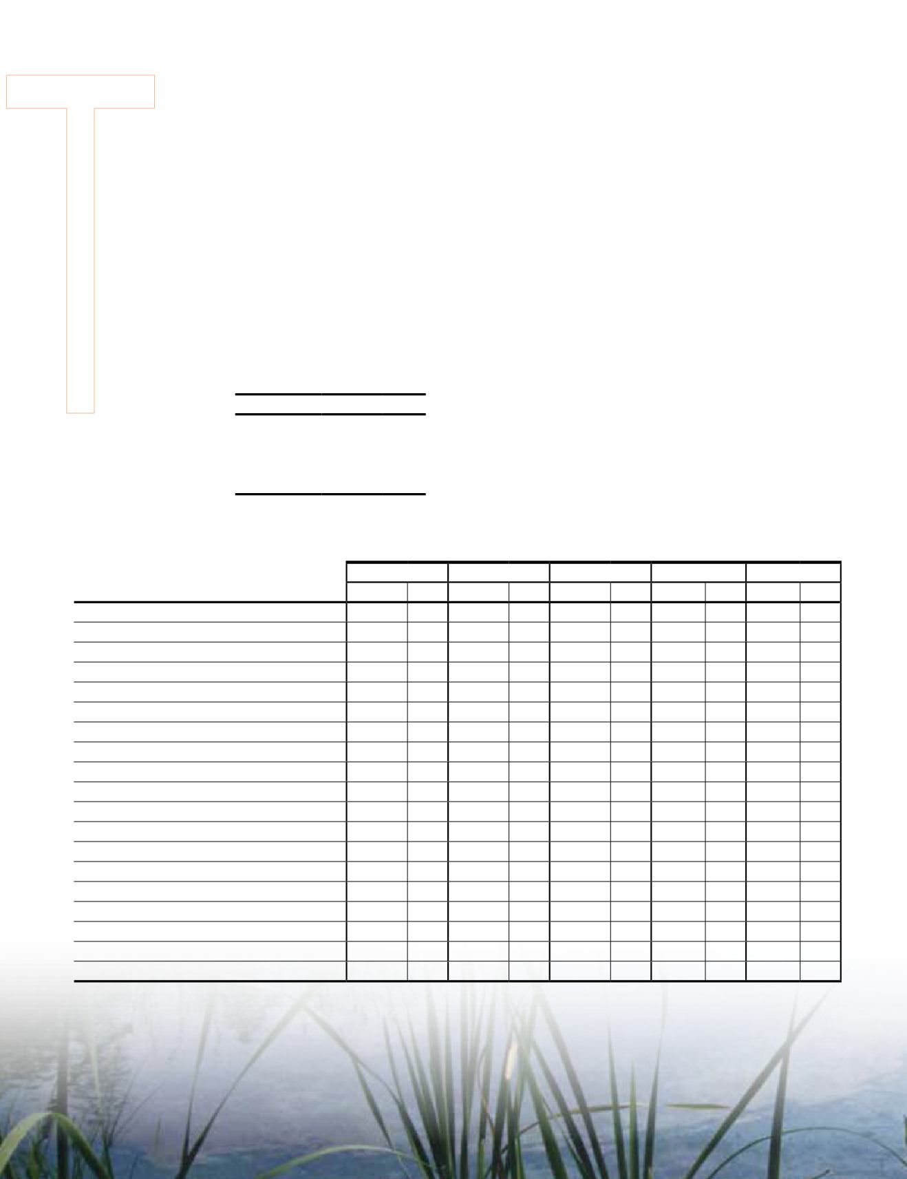
Table 1. Area of change in square
kilometers and percent between the
land cover map of 2005 and 2010.
Area
km
2
%
North America 259,285 1.22
Canada
204,049 2.06
United States
52,294 0.55
Mexico
2,942 0.15
Table 2. Summary statistics from land cover maps and change matrix with area gain, loss, and balance.
LC2005V2
LC2010
Gain
Loss
Balance
km
2
% km
2
% km
2
% km
2
% km
2
%
Temperate or sub-polar needleleaf forest
3,209,808 15.06 3,133,399 14.70 14,418 5.56 90,828 35.03 -76,410 -29.47
Sub-polar taiga needleleaf forest
522,951 2.45 518,359 2.43 9,637 3.72 14,230 5.49 -4,593 -1.77
Tropical or sub-tropical broadleaf evergreen forest
155,347 0.73 155,104 0.73
16
0.01 258 0.10 -242 -0.09
Tropical or sub-tropical broadleaf deciduous forest
162,700 0.76 162,627 0.76
23
0.01
96
0.04
-73 -0.03
Temperate or sub-polar broadleaf deciduous forest 1,617,791 7.59 1,641,647 7.70 34,490 13.30 10,634 4.10 23,856 9.20
Mixed forest
1,386,319 6.50 1,385,318 6.50 31,792 12.26 32,793 12.65 -1,001 -0.39
Tropical or sub-tropical shrubland
960,715 4.51 960,577 4.51 1,208 0.47 1,346 0.52 -138 -0.05
Temperate or sub-polar shrubland
2,615,944 12.27 2,640,422 12.39 69,784 26.91 45,306 17.47 24,478 9.44
Tropical or sub-tropical grassland
33,523 0.16 33,619 0.16
386
0.15 290 0.11
96
0.04
Temperate or sub-polar grassland
1,634,507 7.67 1,673,703 7.85 75,569 29.14 36,373 14.03 39,196 15.12
Sub-polar or polar shrubland-lichen-moss
433,470 2.03 432,423 2.03
167
0.06 1,215 0.47 -1,048 -0.40
Sub-polar or polar grassland-lichen-moss
1,239,877 5.82 1,241,231 5.82 1,926 0.74 572 0.22 1,354 0.52
Sub-polar or polar barren-lichen-moss
615,865 2.89 615,861 2.89
11
0.00
15
0.01
-4
0.00
Wetland
750,883 3.52 744,589 3.49 3,267 1.26 9,561 3.69 -6,294 -2.43
Cropland
2,947,602 13.83 2,944,167 13.81 7,901 3.05 11,337 4.37 -3,436 -1.32
Barren land
1,191,144 5.59 1,191,846 5.59 2,181 0.84 1,480 0.57 701 0.27
Urban and built-up
238,830 1.12 239,590 1.12 1,565 0.60 805 0.31 760 0.29
Water
1,292,067 6.06 1,294,890 6.07 4,924 1.90 2,101 0.81 2,823 1.09
Snow and ice
309,433 1.45 309,405 1.45
19
0.01
46
0.02
-27 -0.01
Note: Areas in square kilometers are rounded. Percentages of classes in the land cover maps are relative to the entire study area (21,318,777 km
2
) but
for gain, loss and balance they are relative to the total change area (259,285 km
2
).
920
October 2014
PHOTOGRAMMETRIC ENGINEERING & REMOTE SENSING


