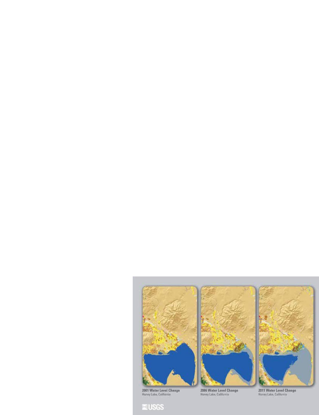
PHOTOGRAMMETRIC ENGINEERING & REMOTE SENSING
May 2015
347
duced commission errors caused by seasonal phenology in ag-
riculture and wetland dominant areas, and reduced omission
errors due to limitations of using one image pair in areas with
clouds and shadows, fire disturbance, forest cutting, and urban
development. Second, the core spectral change detection meth-
od used for NLCD 2011 was an enhanced and improved version
over NLCD 1992, 2001, and 2006 methods (Homer et al., 2004;
Fry et al., 2009; Xian et al., 2009). The 2011 change meth-
od referred to as the Multi-Index Integrated Change Analysis
(MIICA) model (Jin et al., 2013) uses paired Landsat imagery
from 2006 and 2011 to capture a full range of land cover dis-
turbances and land cover changes. The MIICA model accom-
plishes this by using multiple indices for detecting changes,
which recognizes the complementary and sensitivity of each
index in detecting various types of land cover changes. Specific
indices include the Normalized Burn Ratio (NBR), the Normal-
ized Difference Vegetation Index (NDVI), the Change Vector
(CV), and the Relative Change Vector (RCV) (Jin et al., 2013).
The four indices were first computed for each pixel of a Land-
sat scene and then subsequently differenced by 2006 and 2011
scene pairs. During computation, MIICA uses global means
and standard deviations from the four spectral indices to set
relative image path/row thresholds to determine change areas
and to differentiate the change direction (i.e., biomass increase
or decrease) between the two time periods (Jin et al., 2013).
For 2011, the MIICA model was also enhanced with a sep-
arate process called the Zone model (Jin et al., 2013). This
model uses two pairs of NBR change and NDVI change imag-
es across a growing season to identify change areas related to
forest disturbance and succession. Because the Zone model is
more sensitive to the sometimes subtle spectral change from
forest cutting and regrowth than the MIICA model, results
were used to reduce MIICA omission errors in forest change
areas, especially for regions where forests can regrow rapidly.
I
ntegrated
L
and
C
over
C
hange
L
abeling
After the MIICA change detection process identified areas
of potential change, additional steps were
required to determine if the change was val-
id and to appropriately label the land cover
change between 2006 and 2011. To accomplish
this, several steps were required: (1) enhanc-
ing and refining training data for land cover
classification; (2) improving land cover classi-
fication by use of three Landsat images from
circa 2011 for each path/row; and (3) estab-
lishing a set of knowledge-based rules for land
cover labeling within spectral change areas for
use in the decision tree algorithm. The goal of
labeling advancements was to improve over-
all classification accuracy and product quality
from NLCD 2006 procedures (Fry et al., 2011),
which used more simple training procedures,
only one date of imagery from each era, and no
knowledge-based rules.
An extensive enhanced training dataset was assembled for
NLCD 2011 to provide land cover training data for spectral
change areas and to provide good balance among different
land cover types in the training data pool. The training pool
also incorporated several national datasets including NASS
CDL (Johnson et al., 2010), NWI data, and hydric soils. A
method that integrated these multi-source, multi-temporal
training data and information on land cover condition and
trajectory into the land cover labeling process was then uti-
lized. This method utilized three Landsat images acquired
from 2011 and several geospatial ancillary datasets (e.g., de-
rivatives and a wetland potential index) to generate an initial
2011 land cover map through a classification tree algorithm.
Then both the land cover map of 2011 and NLCD 2006 were
spatially combined with the spectral change map of 2006–
2011 obtained from the MIICA model to derive a land cover
change map. This land cover change map contains only those
pixels that are identified as change spectrally, and as a class
label change between (2006) and (2011) labels.
P
ost
-C
lassification
P
rocessing
Despite extensive efforts in image pre-processing, spectral
change detection, and change labeling during NLCD 2011 cre-
ation, some mis-classification still occurred, which required
correction by post-classification analysis. This analysis typ-
ically depends upon knowledge-based rules to refine initial
model labeling using the trajectory of land cover history, an
estimate of the expected land cover class extent and distribu-
tion in the year 2011, and other ancillary data sources. Each
specific land cover type required slightly different post-clas-
sification analysis. Urban class pixels had top priority, with
any change related to newly developed lands always being
included in the final land cover change map. For agriculture
classes, CDL was used to assist in post-classification refine-
ment. For wetlands, ancillary data including NLCD 2006,
SSURGO hydric soil, and NWI were combined to limit both
commission and omission errors (e.g., a pixel classified initially


