78
February 2016
PHOTOGRAMMETRIC ENGINEERING & REMOTE SENSING
PHOTOGRAMMETRIC ENGINEERING
& REMOTE SENSING
J
ournal
S
taff
Publisher Dr. Michael Hauck
Editor Russell G. Congalton
Technical Editor Michael S. Renslow
Assistant Editor Jie Shan
Assistant Director — Publications Rae Kelley
Electronic Publications Manager/Graphic Artist Matthew Austin
Photogrammetric Engineering & Remote Sensing
is the official journal
of the American Society for Photogrammetry and Remote Sensing. It is
devoted to the exchange of ideas and information about the applications of
photogrammetry, remote sensing, and geographic information systems. The
technical activities of the Society are conducted through the following Technical
Divisions: Geographic Information Systems, Photogrammetric Applications,
Lidar, Primary Data Acquisition, Professional Practice, and Remote Sensing
Applications. Additional information on the functioning of the Technical
Divisions and the Society can be found in the Yearbook issue of
PE&RS
.
Correspondence relating to all business and editorial matters pertaining to
this and other Society publications should be directed to the American Society
for Photogrammetry and Remote Sensing, 5410 Grosvenor Lane, Suite 210,
Bethesda, Maryland 20814-2144, including inquiries, memberships, sub-
scriptions, changes in address, manuscripts for publication, advertising, back
issues, and publications. The telephone number of the Society Headquarters is
301-493-0290; the fax number is 301-493-0208; web address is
.
PE&RS
.
PE&RS
(ISSN0099-1112) is published monthly by the American So-
ciety for Photogrammetry and Remote Sensing, 5410 Grosvenor Lane, Suite
210, Bethesda, Maryland 20814-2144. Periodicals postage paid at Bethesda,
Maryland and at additional mailing offices.
SUBSCRIPTION
.
For the 2016 subscription year, ASPRS is offering two op-
tions to our
PE&RS
subscribers -- an e-Subscription and the print edition.
E-subscribers can plus-up their subscriptions with printed copies for a small
additional charge. Print subscriptions are on a calendar-year basis that runs
from January through December. Electronic subscriptions run for twelve
months on an anniversary basis. We recommend that customers who choose
both e-Subscription and print (e-Subscription + Print) renew on a calen-
dar-year basis. The new electronic subscription includes access to ten years’
of digital back issues of
PE&RS
for online subscribers through the same
portal at no additional charge. Please see the Frequently Asked Questions
about our journal subscriptions.
The rate of the e-Subscription (digital) Site License Only for USA and
Foreign: $899.00; e-Subscription (digital) Site License Only for Canada*:
$944.00;
Special Offers:
e-Subscription (digital) Plus Print for the USA:
$1,160.00; e-Subscription (digital) Plus Print Canada*: $1,224.00; e-Sub-
scription (digital) Plus Print Outside of the USA: $1,175.00; Printed-Sub-
scription Only for USA: $959.00; Printed-Subscription Only for Canada*:
$1,013.00; Printed-Subscription Only for Other Foreign: $974.00. *Note:
e-Subscription/Printed-Subscription Only/e-Subscription Plus Print for Can-
ada include 5% of the total amount for Canada’s Goods and Services Tax
(GST #135123065).
POSTMASTER
.
Send address changes to
PE&RS
, ASPRS Headquarters, 5410
Grosvenor Lane, Suite 210, Bethesda, Maryland 20814-2144. CDN CPM
#(40020812)
MEMBERSHIP
.
Membership is open to any person actively engaged in the
practice of photogrammetry, photointerpretation, remote sensing and geo-
graphic information systems; or who by means of education or profession
is interested in the application or development of these arts and sciences.
Membership is for one year, with renewal based on the anniversary date
of the month joined. Membership Dues include a 12-month subscription to
PE&RS
. Subscription is part of membership benefits and cannot be deducted
from annual dues. Beginning with the January 2016 issue of
PE&RS
, all
members outside of the USA will receive access to the full digital edition of
the journal rather than the printed copy. Dues for ASPRS Members outside
of the U.S. will now be the same as for members residing in the U.S. Annual
dues for Regular members (Active Member) is $150; for Student members it
is $50 for USA and Canada; $60 for Other Foreign (E-Journal – No hard copy
for all Students); for Associate Members it is $100 (member must be under
the age of 35, see description on application in the back of this Journal). A
tax of 5% for Canada’s Goods and Service Tax (GST #135123065) is applied
to all members residing in Canada
COPYRIGHT 2016
. Copyright by the American Society for Photogrammetry
and Remote Sensing. Reproduction of this issue or any part thereof (except
short quotations for use in preparing technical and scientific papers) may be
made only after obtaining the specific approval of the Managing Editor. The
Society is not responsible for any statements made or opinions expressed
in technical papers, advertisements, or other portions of this publication.
Printed in the United States of America.
PERMISSION TO PHOTOCOPY
.
The appearance of the code at the bottom of the
first page of an article in this journal indicates the copyright owner’s consent
that copies of the article may be made for personal or internal use or for the
personal or internal use of specific clients. This consent is given on the condi-
tion, however, that the copier pay the stated per copy fee of $3.00 through the
Copyright Clearance Center, Inc., 222 Rosewood Drive, Danvers, Massachu-
setts 01923, for copying beyond that permitted by Sections 107 or 108 of the
U.S. Copyright Law. This consent does not extend to other kinds of copying,
such as copying for general distribution, for advertising or promotional pur-
poses, for creating new collective works, or for resale.
20 years ago a NASA press release announced, “El Nino is Back and Strong. According
to NASA, the five years of global ocean topography observations made by TOPEX/Po-
seidon have been a boon for El Nino researchers, who have been able to track three El
Nino events since the satellite’s launch in August 1992.”
Fast forward to January 17, 2016, Jason-3, a U.S.-European satellite mission, lifted
off from Vandenberg Air Force Base in California today at 10:42 a.m. PST aboard a
SpaceX Falcon 9 rocket, to become the latest spacecraft to track the rate of global
sea-level rise. Jason-3 will also help NOAA’s National Weather Service more accurately
forecast the strength of tropical cyclones that threaten America’s coasts.
Jason-3 continues the legacy of the Topex/Poseidon and earlier Jason satellites.
According to Stephen Volz, Ph.D., assistant administrator for NOAA’s Satellite and In-
formation Service, “Jason-3 will tell us about the heat of the ocean, vital data if a
tropical storm or hurricane is tracking into that location. Having up-to-date sea surface
temperatures will help NOAA forecasters better determine if a storm may intensify.”
“Jason-3 is a prime example of how our nation leverages NASA expertise in space
and scientific exploration to help address critical global challenges in collaboration with
NOAA and our international partners,” said John Grunsfeld, associate administrator for
science at NASA Headquarters.
Coordinating orbits and combining measurements from Jason-2 and Jason-3 should
allow even more frequent coverage of the global oceans. Together, the two spacecraft
will double global data coverage. This tandem mission will improve our knowledge of
tides in coastal and shallow seas and internal tides in the open ocean, while improving
our understanding of ocean currents and eddies.
Measurements of sea-surface height, or ocean-surface topography, reveal the speed
and direction of ocean currents and tell scientists how much of the sun’s energy is
stored by the ocean. Combining ocean current and heat storage data is key to under-
standing global climate changes.
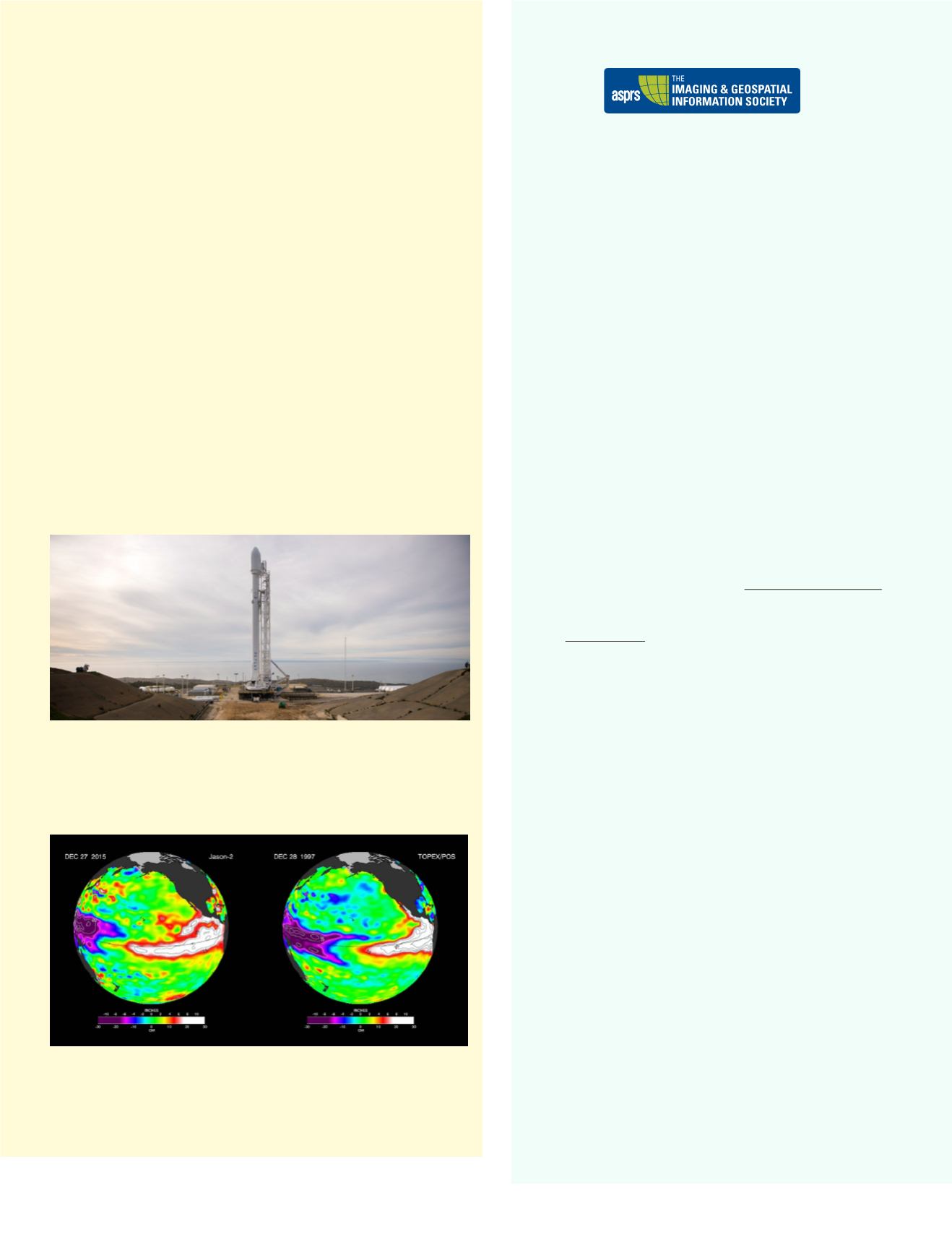
The SpaceX Falcon 9 rocket is seen at Vandenberg Air Force Base Space Launch Com-
plex 4 East with the Jason-3 spacecraft onboard, Saturday, Jan. 16, 2016, in Califor-
nia. Jason-3, an international mission led by the National Oceanic and Atmospheric
Administration (NOAA), will help continue U.S.-European satellite measurements of
global ocean height changes. Jason-3 was successfully launched the next day. Credits:
NASA/Bill Ingalls
A side by side comparisons of Pacific Ocean sea surface height (SSH) anomalies of
what is presently happening in 2015 with the Pacific Ocean signal during the famous
1997 El Niño. Data are from the TOPEX/Poseidon (1997) and the successor OSTM/
Jason-2 (2015) satellites. Credits: NASA’s Jet Propulsion Laboratory


