Moreover, the combination of laboratory experiments and
field observations and the comparison between laboratory
and field data can improve the understanding on the failure
mechanism (Hurlimann
et al.
, 2015). One of the challenges in
the scaled-down model experiments is the deformation detec-
tion of the entire surface instead of merely a few points. Such
spatial patterns are critical for the landslide mechanism study.
Furthermore, temporal variations of these spatial patterns are
a useful tool for analyzing landslides in different conditions
and important for long term and short term predictions.
This study presents a dynamic photogrammetric processing
method for surface deformation measurements applied to labo-
ratory landslide simulation experiments. A landslide simulation
facility was constructed at Tongji University in Shanghai, China,
to reproduce rainfall-induced landslides (Plate 1). The objec-
tives are (a) to detect pre-failure events and the final collapse
using the sequential imagery, (b) to provide sectional and overall
surface deformation patterns before and during the landslide
collapse, and (c) to generate speed maps during the rapid slope
failure based on the stereo imagery. The photogrammetric solu-
tion under investigation is based on multiple digital cameras,
along with other types of sensors, which are able to capture the
entire process of the relatively long pre-failure process, short
and intense failure events, and post-failure events in a non-con-
tact and controlled manner. The recorded sequences of stereo
images were incorporated into the overall sensor network obser-
vation framework. A systematic photogrammetric methodology
was developed for reconstructing critical deformation processes
using a series of techniques, including image processing, feature
tracking, 3D reconstruction, and velocity calculation. The
experimental results validated an effective event search strategy
that detects slower local collapses at a low imaging rate and the
fast slope failure process at a high imaging rate. The developed
photogrammetric approach and the overall landslide monitoring
strategy can provide important surface deformation information
for the study of simulated landslide failure mechanisms.
Landslide Simulation Platform
Scaled-down landslide simulation models have been used to
improve the knowledge of landslide failure mechanisms. Such
models allow researchers to simulate landslides in a controlled
environment and to analyze the relationships between observed
parameters and the stability of a slope. As reviewed in Scaioni
et
al
. (2015) and Lu
et al
. (2015), scaled-down models can be con-
structed in a laboratory or in the field. In either case, the deploy-
ment of a sensor network can be used to record as many useful
parameters as possible for the study of failure mechanisms.
In this study, a scaled-down simulation platform was con-
structed on the main campus of Tongji University in Shang-
hai. The geometry of this system was designed to reproduce
a landslide-prone slope near the small town of Taziping in
Sichuan Province, western China, where the 2008 Wenchuan
Earthquake elevated the threat of rainfall-induced landslides
because of loose soils and layers on the slope at various
depths (Qiao
et al
., 2013). Although the landslides in this
area may be slow and intermittent for a relatively long period,
they can accelerate rapidly under the conditions of intensive
precipitation, and further turn into rapid-moving landslides
and debris flows (Cui
et al.
, 2011; Tang
et al.
, 2011). Consider-
ing most landslide deposits are not uniform in western China,
the landslide mass in our simulated experiment is divided
into two layers, a 0.4 m layer of mixed clay and sand on top
and a 0.6 m layer of mixed gravel, clay and sand at bottom to
simulate the material composition based on the field survey
in Taziping area (Lu
et al.
, 2015). For real-time monitoring
purposes, this platform was designed and implemented to
include an artificial rainfall system, a landslide body, a sensor
network, a subsystem for data collection and communication,
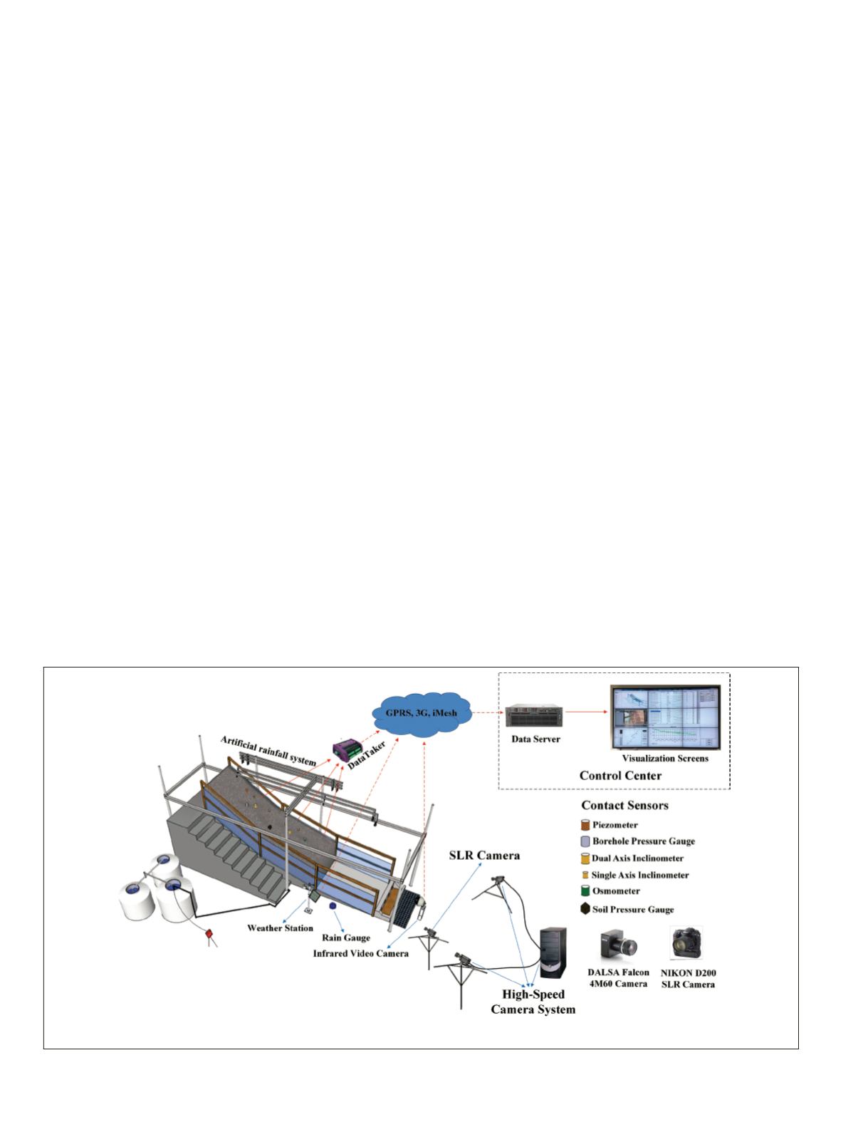
and a nine-screen panel for landslide visualization (Plate 1).
The size of the landslide body is 6 m × 1.5 m × 3 m (length,
width and maximum height, respectively), with three slope
sections featuring inclinations of 30°, 15°, and 5°.
The sensor network contains contact sensors, i.e., soil pres-
sure gauges, borehole pressure gauges, inclinometers, piezom-
eters, and an osmometer (Plate 1). These sensors record the
environmental conditions and geotechnical parameters of the
landslide body (Scaioni
et al
., 2013). The imaging sensors cap-
ture the geometric changes in the slope surface during a simu-
lated landslide deformation process. A NIKON D200 single-
lens-reflex (
SLR
) camera (hereafter referred to as
SLRC
) collects
the landslide surface changes at a relatively low frequency (a
Plate 1. The scaled-down landslide simulation platform at Tongji University.
548
July 2016
PHOTOGRAMMETRIC ENGINEERING & REMOTE SENSING


