PHOTOGRAMMETRIC ENGINEERING & REMOTE SENSING
July 2016
461
of point density of the linear lidar data, which was collected
in leaf-on season (June). In fact, many SPL ground points are
located in the lower middle triangle region where little forest
exists. The SPL point density for the majority of the ground is
1.0-2.0 points per sq. meter, i.e. the vast majority of the SPL
raw points are from forest canopy. This ground point density
is still as 3.8 - 7.7 times higher than the linear lidar density.
However, since the SPL data was collected in leaf-off season
(November), we could not conclude if the same or equivalent
point density would still be expected when operated in leaf-
on season. The ‘penetration’ capability of SPL remains to be
further investigated.
U
ncertainty of
SPL
measurements
We intended to study the performance of SPL by looking into
its interaction with specific ground features. To this end, we
selected three roofs from the Urban dataset. In addition, a small
pond in the south part of the same dataset was also selected,
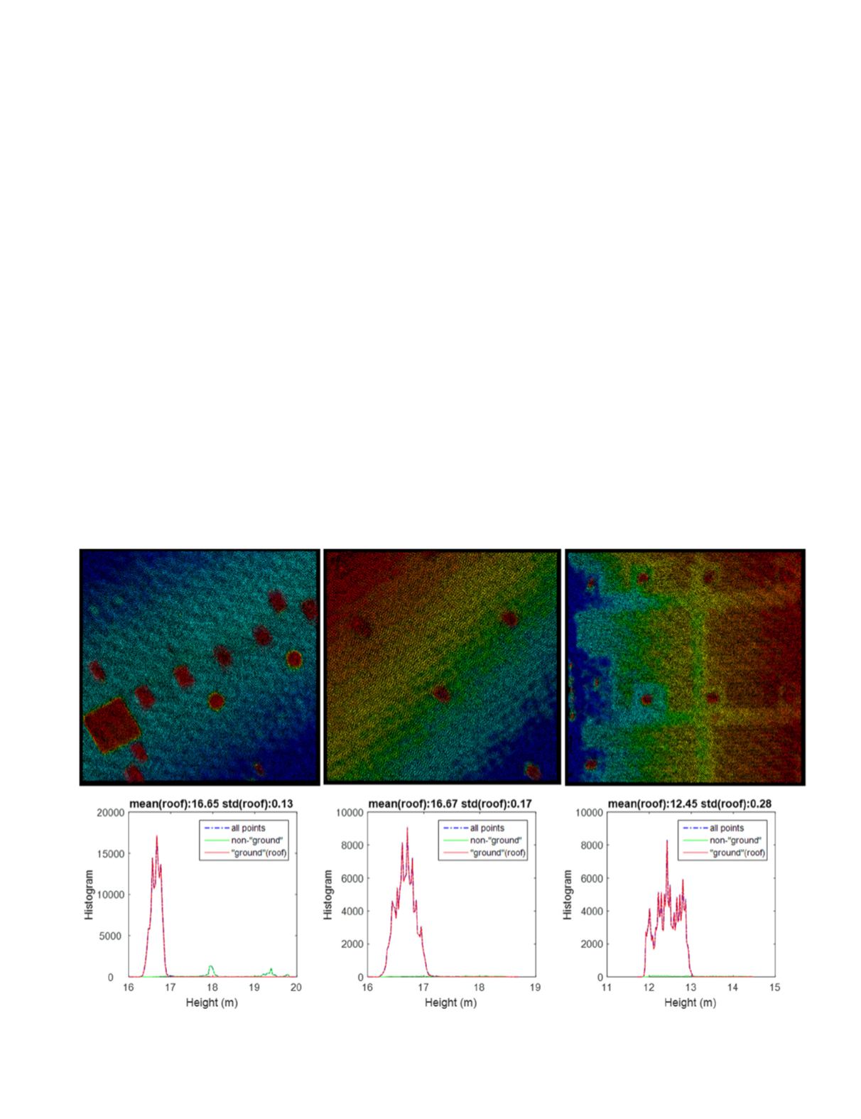
which can be assumed to be perfectly flat. Figure 2 (middle)
marks the locations of the three roofs and the pond. The point
clouds of the three roofs and their elevation histograms are
shown in Figure 8, which shows that none of the roofs are
perfectly flat. Roof 1 has several small high-rise attachments,
while Roof 2 and 3 are slightly sloped. The height standard
deviations are 0.13 m, 0.17 m and 0.28 m, respectively for the
three roofs. We cannot imply the vertical uncertainly of the
SPL sensor by using the three roof samples, but it is safe to
say that it is able to detect height differences at a magnitude
of at least 0.2 m.
As for the pond, Figure 9 shows a section of its street view,
the SPL points, and the corresponding height histogram. A
peak pulse in the height histogram is found at 4.71 m, which
should be the height of the pond with respect to the vertical
datum. The standard deviation 0.09 m of the histogram then
likely comes from SPL’s noise or sensitivity and suggests the
intrinsic uncertainty of the SPL measurements.
To further investigate and verify the sensitivity of SPL, we
repeated our work onwater pond for the river water in the Bathy
dataset. In Figure 10, we selected a sample of 364 x 340 m
2
from
the water area marked by the red box in Figure 3. There are
291,547 points in total. Some of them are on the riverbed, and
the others are on the water surface. We extracted the water
surface points by vertically reversing the data and running
ground filtering. It returned 190,253 ‘ground’ points that are
the water surface, yielding a point density of 1.5 points per
sq. meter and ground spacing 0.82 m. The height histograms
Figure 8. The SPL point clouds (top) and their height histograms (bottom) for the three roofs.


