170
April 2018
PHOTOGRAMMETRIC ENGINEERING & REMOTE SENSING
INDUSTRY
NEWS
To have your press release published in
PE&RS
, contact Rae Kelley,
.
ANNOUNCEMENTS
AirGon LLC, a wholly owned subsidiary of GeoCue Group Inc.,
has been appointed the North American Distributor for Yel-
lowScan, based in Montpellier, France. Under the agreement,
AirGon will sell, train and support YellowScan’s complete line
of small Unmanned Aerial Vehicles (sUAV) LIDAR scanning
systems. The system choices range from the mapping grade
YellowScan Mapper to the advanced, Riegl-based YellowScan
VX and the new Velodyne VLP32C- based Surveyor Ultra.
“We are very pleased with this superb addition to our AirGon
solution offerings,” said Lewis Graham, General Manager of
AirGon and President of GeoCue Group.
“We are very excited to name AirGon LLC our North American
distributor,” said Pierre d´Hauteville, CEO of YellowScan.
“The GeoCue Group has been providing consulting, training
and software for the manned aerial and mobile LIDAR
community since its inception.
The Agreement was effective in December of 2017. AirGon
owns a demonstration YellowScan system mounted on a DJI
m600 sUAS platform. Contact
to discuss
your drone mapping questions.
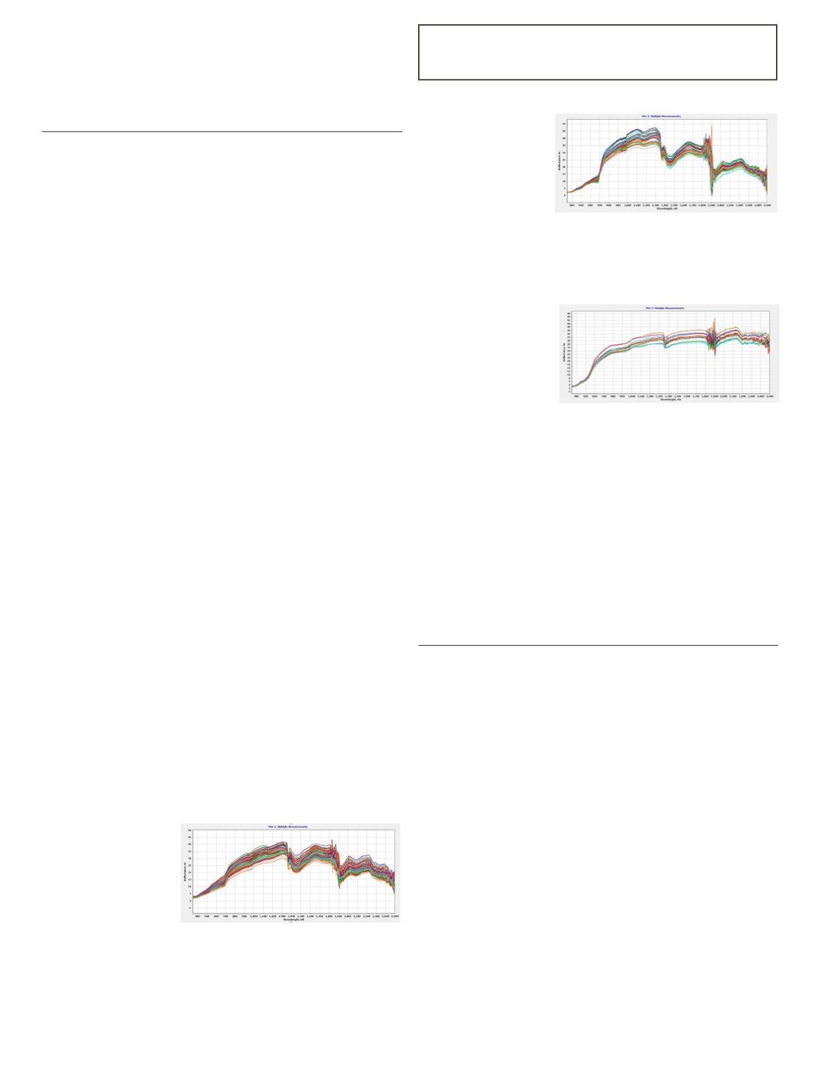
A SPECTRAL EVOLUTION distributor in China, Azup Inter-
national Group, Ltd., worked with Beijing Anzhou Technol-
ogy Co. Ltd on attaching a PSR+ field spectroradiometer to
an eight rotor UAV for measuring ground cover across three
fields as a test of measurement and stability.
The system included:
• An eight rotor UAV
• Integrated gimbal PTZ camera for stable imagery
acquisition
• Full automatic aerial survey
• Flight control triggering of data acquisition
• GPS coordinates simultaneously obtained
• Object image synchronization storage
• A variety of modes for route designation
• High resolution/low noise spectra
• Pre-lens can be reduced to field of view
Test One
Field route coverage
of about 800 meters
by
200
meters.
Weather was sunny.
Flight
parameters
included 30 meter
altitude with a field of
view angle of 25 degrees, flight interval of 50 meters with an
equidistant triggering distance of 50 meters. Scans triggered
by flight control system for measurement—isometric trigger
set to 50 meters.
Test Two
Lashi Hainan region
with
thin
cloud
coverage for weather.
Flight
parameters
included altitude of
20 meters, field of
view angle of 25 degrees, flight interval 20 meters, equidistant
triggering distance of 30 meters. Scans triggered by flight
control system, set with a 30 meter equidistant trigger.
Test Three
Tai’an potato base—
bare field. Stable light
with a cloud around
the
sun.
Flight
parameters included
altitude of 30 meters,
field of view angle of
25 degrees, flight interval of 20 meters, equidistant triggering
of 30 meters. Scans triggered by flight control system, set with
a 30 meter equidistant trigger.
Conclusions
The UAV and PSR+ system was stable and captured reliable
data. Airborne measurement was efficient with no damage
to the sites. Measurements taken with a system like this can
save labor and improve efficiency.
For more information, visit
CALENDAR
• April 9-13,
URISA GIS Leadership Academy
,
Columbus, Ohio. For more information, visit
urisa.org/education-events/urisa-gis-leadership-academy/.
• April 22-24,
Inaugural Joint UESI-Cal Poly Pomona
2018 Surveying & Geomatics Conference
, Pomona,
California. For more information, visit
conference.org/.
• April 26-27,
EnerGIS
, Canonsburg, Pennsylvania. For
more information, visit
/.
• May 9-11,
15
th
Conference on Computer and Robot
Vision (CRV 2018)
, Toronto, Ontario, Canada. For more
information, visit
/.
• July 18-22,
COSPAR 2018
, Pasadena, California. For
more information, visit
or
/.
• July 23-27,
URISA GIS Leadership Academy
, Salt
Lake City, Utah. For more information, visit
urisa.org/education-events/urisa-gis-leadership-academy/.


