PHOTOGRAMMETRIC ENGINEERING & REMOTE SENSING
May 2018
237
Productivity Comparison Between
Medium and Large Format Cameras
Productivity comparison is commonly based on the following
parameters: aerial survey productivity (image coverage per
hour of flight), distance between flight lines, time required to
fly Area of Interest (AOI) or number of flight lines per AOI. A
more objective criterion, not depending on the ground speed
of the plane and the shape of AOI, is the distance between
flight lines. The following orthophoto geometrical parameters
were used for calculations:
GSD Orthophoto
angle
Building
lean
Ground
Speed
Minimal
side overlap
5 cm 14°
12% 120 knot
25%
8 cm 17°
15% 140 knot
25%
10 cm 20°
18% 160 knot
25%
15 cm 25°
22% 180 knot
25%
Based on the above assumptions, the following charts and ta-
bles present the productivity comparison for Phase One me-
dium format cameras, Vexcel UltraCam Eagle and Hexagon
DMC III large format cameras. Corresponding focal lengths
of the cameras are presented in parenthesis.
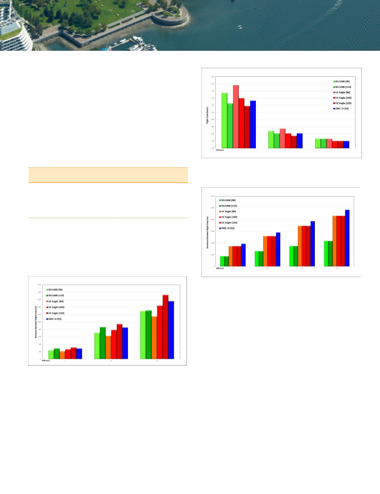
Figure 3 demonstrates that with the requirement for orthopho-
to angle/building lean for urban orthophoto, medium and large
format cameras provide similar distance between flight lines.
Figure 4 presents the time of flight needed to cover an area
of 5 km by 5 km.
The same conclusion can be drawn from Figure 4. The require-
ment for orthophoto angle/building lean in urban environment
equals the productivity of medium and large format cameras.
Figure 5 presents another situation common for other photo-
grammetric products: orthophoto for rural area, dense DSM
or stereocompilation – flight without specific limitations on
orthophoto angle with the minimal side overlap of 25% and
with maximal use of the sensor (CCD/CMOS) area.
In this case, Phase One medium format cameras provide 50%
of UC Eagle productivity and 45% of DMC III productivity,
independently from the ground resolution. However, taking
into consideration the relatively low purchase price of Phase
One cameras, its utilization for medium size urban and rural
mapping projects may be considered.
The wide range of exchangeable metric lenses with different
focal lengths enables the use of Phase One cameras at differ-
ent altitudes (Figure 6) with different flight platforms and for
a variety of different purposes.
Figure 3. Distance between flight lines with multiple cameras from
Phase One, UC Eagle and DMC III for orthophoto at 5 - 15 cmGSD.
Figure 4. Flight time with Phase One, UC Eagle and DMC III for
orthophoto at 5 - 15 cm ground sampling distance for an area of
5km x 5km.
Figure 5. Distance between flight lines for rural area with 25% side
overlap.


