PHOTOGRAMMETRIC ENGINEERING & REMOTE SENSING
May 2019
333
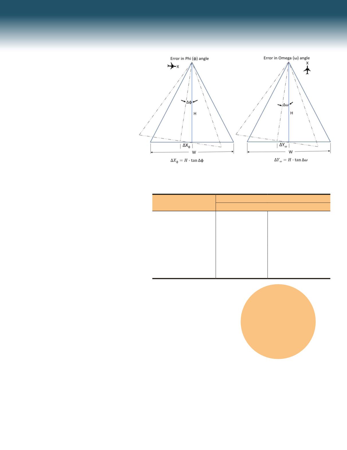
Figure 2. First order estimation of ground error from aerial photogrammetry.
Flying Altitude AGL
(ft.)
Horizontal Error in X or Y
ft.
cm
50.0
0.004
0.11
100.0
0.007
0.22
150.0
0.011
0.33
200.0
0.015
0.44
400.0
0.029
0.89
3000.0
0.218
6.65
6000.0
0.436
13.30
10000.0
0.727
22.17
Table 1. Flying altitude effect on product accuracy when 15 arc seconds error exist in
camera orientation.
Small Project Size
The smaller size of projects associated with UAS
acquisition helps minimize the error sources
in the bundle block adjustment and eventually
results in a better management for the error
modeling during adjustment. In addition,
smaller project size translates to fewer number
of images and therefore a better ratio of images
to ground control points, assuming ground
control points are used in the block adjustment.
Image Redundancy
UAS-based imagery is usually flown with
excessive forward and side overlap. Such
increased overlap results in increased “reliability
figure”. The reliability figure is an important
measure for estimating the quality and the
fidelity of the photogrammetric solution.
Several factors have contributed to the success
in UAS-based photogrammetry, including the
following:
Low-Altitude and High-Resolution Imagery
Low-altitude imaging not only results in high-
resolution imagery (see Figure 1), it minimizes
the effect of the altitude errors on the derived
products. After the aerial triangulation solution,
there will always be residual errors in the
computed camera attitudes angles. The effect of
such errors on the derived products is linearly
proportional to the flying altitude as illustrated
in Figure 2 and the following equations:
Δ
Y
ω
=
H
· tan Δ
ω
(1)
Δ
X
ф
=
H
· tan Δф
(2)
where,
Δω = Omega error
Δф = Phi error
Δ
Y
ω
= Position error caused by error in Omega
Δ
X
ф
= Position error caused by error in Phi
H = Flying altitude.
As Equations 1 and 2 demonstrate, the higher
we fly the sensor, the more errors are introduced
in the positions of the derived products. Figure
2 illustrates the influence of flying altitude on
the estimated products’ accuracy derived from
photogrammetry or lidar. With manned aircraft,
we usually fly around 3,000 feet to 10,0000 feet
above ground level, while most of UAS missions
are conducted from an altitude of 70 feet to 200
feet. Such low-altitude results in lower positional
errors caused by the errors in sensor orientation
angles determination from aerial triangulation.
To illustrate the impact of flying altitude on
resulting accuracy, Table 1 lists the estimated
horizontal positional errors caused by an error
of 15 arc seconds in omega and phi during the
aerial triangulation process (as computed using
Equations 1 and 2). Such remaining error in the
camera orientation determination is expected,
and the value of 15 arc seconds is realistic even
for high-quality aerial triangulation adjustment.
Table 1 clearly shows that those positional errors
remain low for UAS flights (i.e. flown under 400
feet) but are much higher for typical imaging
missions using manned aircraft.
“This excitement
pushed people to
purchase a low-cost
drone and start
acquiring aerial
imagery over their
neighborhood,
community, church,
wedding, real estate
property, etc.”


