328
May 2019
PHOTOGRAMMETRIC ENGINEERING & REMOTE SENSING
PHOTOGRAMMETRIC ENGINEERING
& REMOTE SENSING
J
ournal
S
taff
Publisher ASPRS
Editor-In-Chief Alper Yilmaz
Assistant Editor Jie Shan
Assistant Director — Publications Rae Kelley
Electronic Publications Manager/Graphic Artist Matthew Austin
Photogrammetric Engineering & Remote Sensing
is the official journal
of the American Society for Photogrammetry and Remote Sensing. It is
devoted to the exchange of ideas and information about the applications of
photogrammetry, remote sensing, and geographic information systems. The
technical activities of the Society are conducted through the following Technical
Divisions: Geographic Information Systems, Photogrammetric Applications,
Lidar, Primary Data Acquisition, Professional Practice, and Remote Sensing
Applications. Additional information on the functioning of the Technical
Divisions and the Society can be found in the Yearbook issue of
PE&RS.
Correspondence relating to all business and editorial matters pertaining to this
and other Society publications should be directed to the American Society for
Photogrammetry and Remote Sensing, 425 Barlow Place, Suite 210, Bethesda,
Maryland 20814-2144, including inquiries, memberships, subscriptions,
changes in address, manuscripts for publication, advertising, back issues,
and publications. The telephone number of the Society Headquarters is 301-
493-0290; the fax number is 225-408-4422; web address is
.
PE&RS.
PE&RS
(ISSN0099-1112) is published monthly by the American
Society for Photogrammetry and Remote Sensing, 425 Barlow Place, Suite
210, Bethesda, Maryland 20814-2144. Periodicals postage paid at Bethesda,
Maryland and at additional mailing offices.
SUBSCRIPTION.
For the 2019 subscription year, ASPRS is offering two options
to our
PE&RS
subscribers — an e-Subscription and the print edition.
E-subscribers can plus-up their subscriptions with printed copies for a small
additional charge. Print and Electronic subscriptions are on a calendar-year
basis that runs from January through December. We recommend that custom-
ers who choose both e-Subscription and print (e-Subscription + Print) renew
on a calendar-year basis. The new electronic subscription includes access to
ten years of digital back issues of
PE&RS
for online subscribers through the
same portal at no additional charge. Please see the Frequently Asked Questions
about our journal subscriptions.
The rate of the e-Subscription (digital) Site License Only for USA and Foreign:
1000.00 USD; e-Subscription (digital) Site License Only for Canada*: 1049.00
USD; Special Offers: e-Subscription (digital) Plus Print for the USA: 1365.00
USD; e-Subscription (digital) Plus Print Canada*: 1424.00 USD; e-Subscription
(digital) Plus Print Outside of the USA: 1395.00 USD; Printed-Subscription
Only for USA: 1065.00 USD; Printed-Subscription Only for Canada*: 1124.00
USD; Printed-Subscription Only for Other Foreign: 1195.00 USD. *Note:
e-Subscription/Printed-Subscription Only/e-Subscription Plus Print for
Canada include 5% of the total amount for Canada’s Goods and Services Tax
(GST #135123065).
PLEASE NOTE: All Subscription Agencies receive
a 20.00 USD discount.
POSTMASTER.
Send address changes to
PE&RS
, ASPRS Headquarters,
425 Barlow Place, Suite 210, Bethesda, Maryland 20814-2144. CDN CPM
#(40020812)
MEMBERSHIP.
Membership is open to any person actively engaged in the practice
of photogrammetry, photointerpretation, remote sensing and geographic
information systems; or who by means of education or profession is interested
in the application or development of these arts and sciences. Membership is
for one year, with renewal based on the anniversary date of the month joined.
Membership Dues include a 12-month electronic subscription to
PE&RS
. Or
you can receive the print copy of
PE&RS
Journal which is available to all
member types for an additional fee of 60.00 USD for shipping USA, $65 USD
for Canada, or 75.00 USD for international shipping. Dues for ASPRSMembers
outside of the U.S. will now be the same as for members residing in the U.S.
Annual dues for Regular members (Active Member) is 150 USD; for Student
members 50 USD for USA and Canada 58 USD; 60 USD for Other Foreign
members. A tax of 5% for Canada’s Goods and Service Tax (GST #135123065)
is applied to all members residing in Canada.
COPYRIGHT 2019.
Copyright by the American Society for Photogrammetry and
Remote Sensing. Reproduction of this issue or any part thereof (except short
quotations for use in preparing technical and scientific papers) may be made
only after obtaining the specific approval of the Managing Editor. The Society
is not responsible for any statements made or opinions expressed in technical
papers, advertisements, or other portions of this publication. Printed in the
United States of America.
PERMISSION TO PHOTOCOPY.
The appearance of the code at the bottom of the
first page of an article in this journal indicates the copyright owner’s consent
that copies of the article may be made for personal or internal use or for the
personal or internal use of specific clients. This consent is given on the condition,
however, that the copier pay the stated per copy fee of 3.00 USD through the
Copyright Clearance Center, Inc., 222 Rosewood Drive, Danvers, Massachusetts
01923, for copying beyond that permitted by Sections 107 or 108 of the U.S.
Copyright Law. This consent does not extend to other kinds of copying, such
as copying for general distribution, for advertising or promotional purposes,
for creating new collective works, or for resale.
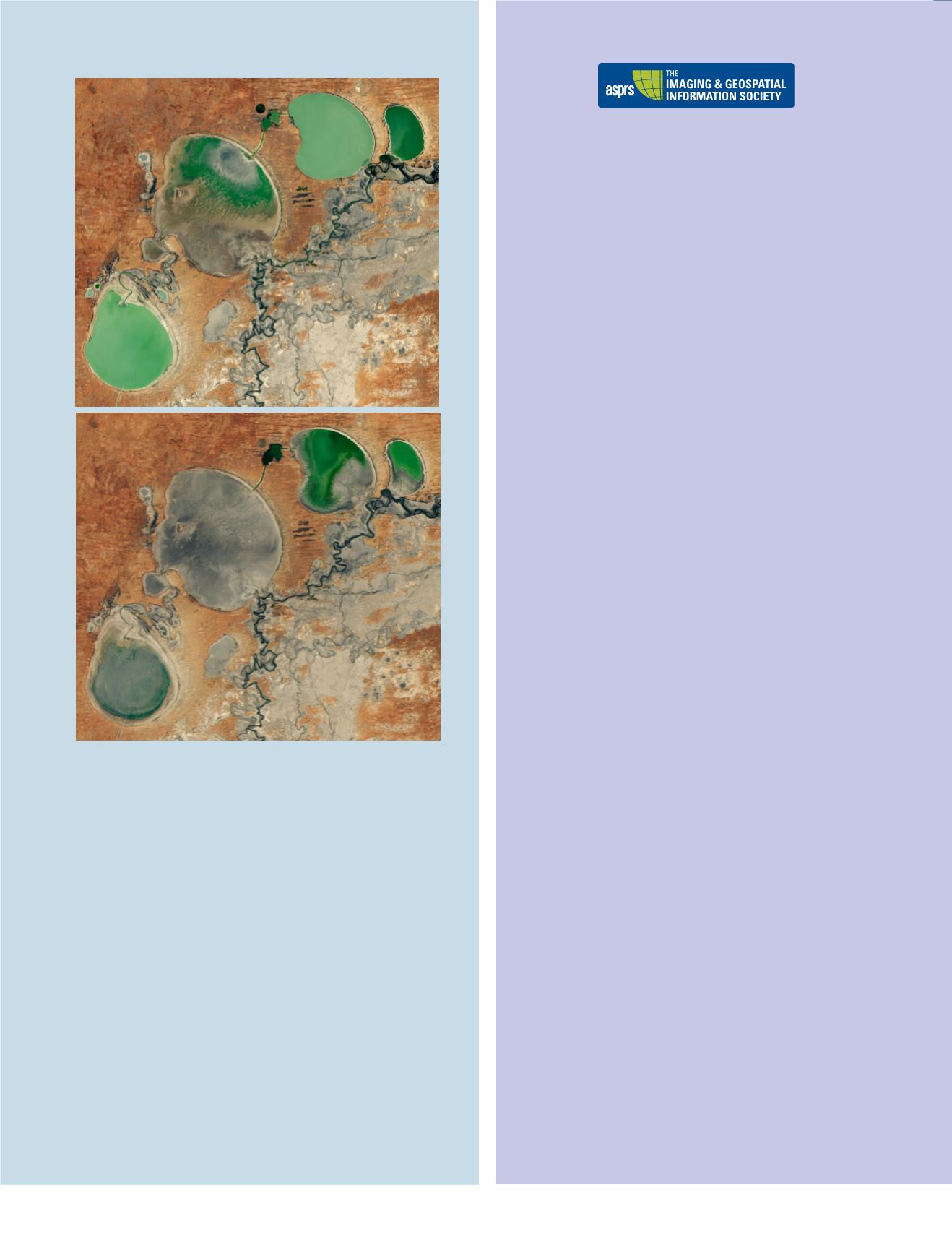
In December 2016, the Menindee Lakes of New South Wales were nearly brimming
with water. More than two years later, these Australian lakes are almost desiccated.
These satellite images show the dwindling water levels of the Menindee Lakes, a
chain of freshwater lakes located 110 kilometers (70 miles) southeast of Broken Hill.
The shallow natural depressions were developed into water storage by the Austra-
lian government to manage river flows. The images were acquired by the Operational
Land Imager on Landsat 8 on January 27, 2017 (cover image), February 15, 2018, and
February 2, 2019.
Water levels often fluctuate as the basins collect precipitation or flood water. Evapora-
tion accounts for about 400 gigalitres of water loss from the lakes every year. Other times
the water is released into the nearby Darling River by the New South Wales government.
During drought, when less water is coming into the lakes, the basins tend to be drier.
Lake Menindee is the largest of the lakes. But river managers have been keeping
as much water as possible upstream in Lake Wetherell and Lake Panamaroo, which
supply water to Broken Hill and local communities.
Recent years have brought exceptional drought to the area. New South Wales has
faced extremely hot temperatures and low precipitation, causing one of its worst
droughts on record.
The Lower-Darling River has been experiencing “extreme low inflows” of water from
the Menindee Lakes since August 2018. As of February 18, 2019, the Lower-Darling’s
storage level was 1 percent. Water has stopped flowing in parts of the river.
For more information, visit
NASA Earth Observatory image by Lauren Dauphin, using Landsat data from the U.S.
Geological Survey. Story by Kasha Patel.
February 2, 2019
February 15, 2018


