
Who We Are
Over 100 Individual Members
35 Certified Professionals
Meet our Board
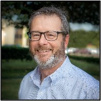
Bill Swope, CP
President
Bill Swope is the Geospatial & Survey Business Development Manager for Halff Associates, Inc., in Richardson, Texas and a Certified Photogrammetrist (CP #1604) through ASPRS. Bill has been in the geospatial industry for over 14 years and is experienced in all aspects of photogrammetry including aero-triangulation, stereo compilation, planimetric data collection, map editing, and QA/QC procedures. Bill is well versed in manned fixed-wing and rotor based photogrammetric and LiDAR data collection procedures and processes along with experience working with small unmanned aerial systems (sUAS), mobile LiDAR, and terrestrial based high-definition 3D scanning. Bill is the Assistant Director for the Professional Practice Division of ASPRS, and a State Representative for Texas for the Mid-South Region, now the Gulf South Region. Bill was voted the 2019 Geospatial Professional of the Year by the Texas Society of Professional Surveyors (TSPS), serves on the North Central Texas Council of Governments UAS Security and Integration Task Force, and advises several ISD’s in North Texas on their UAS programs as an industry partner.
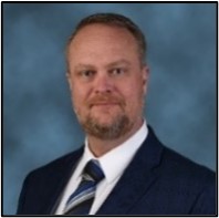
Cody Condron, CP, CMS-UAS, RPLS
Vice President
Mr. Condron has over 30 years of experience in Photogrammetry and Land Surveying. He is both a Registered Professional Land Surveyor and Certified Photogrammetrist. Additionally, he is the first Certified Mapping Scientist – UAS and is also a licensed UAS pilot. He began his career working summers and after school for his father’s surveying firm located in North Houston. Mr. Condron continued his development after High school at Texas A&M – Corpus Christi in the Geomatics program. After college Mr. Condron has work throughout the state of Texas gaining extensive experience and knowledge in Control Surveys, Topographic Surveys, Boundary Surveys, Construction Staking, Aerial Mapping, Bathymetric Surveys and Land Development. He has performed work with public and private entities, including US Department of Veteran Affairs, US Forestry Department, TxDOT, City of Houston, Exxon Mobil, Chevron and many more. Due to Mr. Condron’s diverse and broad background, he has gained experience as an expert witness for numerous cases that require extensive knowledge relating to all aspects of surveying. Since 2020 Mr. Condron has served as a state representative of Texas for the Mid-South Region of ASPRS and Director for Chapter 9 of TSPS. Additionally, Mr. Condron volunteers as an assistant adjunct professor for Texas A&M -Corpus Christi field camp II, serves on the Klein ISD CTE Advisory Council, advises Aldine ISD on their Geomatics Program and is the Survey Manager of Texas for KCI Technologies.
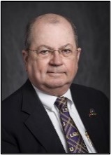
Clifford Mugnier, CP
Immediate Past President
Cliff Mugnier is a board-certified Photogrammetrist and a board-certified Mapping Scientist. He was the National Director of the Photogrammetric Applications Division of the American Society for Photogrammetry and Remote Sensing (ASPRS). He has 30+ years of experience as an Expert Witness in forensic applications of the mapping sciences in both State and Federal Courts. His experience in the research on the geodesy of subsidence in Louisiana dates back to his first seminar presentation to the Louisiana Society of Professional Land Surveyors (LSPS), in 1979. Cliff was a commissioned officer in the Corps of Engineers and reached the rank of Captain at Army Map Service during the Vietnam War. Cliff has been a part-time member of the faculty of Civil Engineering at the University of New Orleans for 20 years and since 2000 has been a full-time member of the faculty of Civil Engineering at Louisiana State University in Baton Rouge where he taught Surveying, Geodesy, and Photogrammetry and is now retired. He is a Lifetime Honorary Member of the LSPS, and he a Fellow Emeritus of the ASPRS. Cliff is also a full member of the Americas Petroleum Survey Group (APSG); he is classified as an Expert in NRA Conventional Bullseye Pistol competition, and he is the father of 5 sons and 2 daughters, all grown.
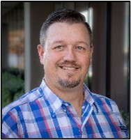
Russell Lestina
Secretary
Russell Lestina is an HDS Specialist and Survey Technician at Halff Associates, Inc., in Richardson, Texas and a FAA Certified Part 107 sUAS Pilot. Russell has been working with terrestrial LiDAR scanners for the past 13 years and has been working with sUAS utilizing both photogrammetry and LiDAR, for the past 3 years. Russell is highly experienced processing and extracting LiDAR data collected with terrestrial LiDAR scanners, sUAS and mobile LiDAR systems. Additionally, Russell has over sixteen years of experience with land surveying practices including topographic surveys, boundary surveys, construction layouts, right-of-way surveys, and utility surveys. Russell is proficient with several software packages and computer mapping programs including MicroStation, AutoCAD, TopoDOT, Cyclone, Register360, Leica Infinity, Trimble Real Works, EdgeWise, Trimble Business Center, Adobe Premiere Pro, ReCap, Pix4D, ScanLook and QT Reader.

Dogukan "DJ" Dogru
Treasurer
DJ is Geomatics Engineer and FAA Certified sUAS Pilot who has been heavily involved with Geospatial and Surveying profession since 2010. “I believe there is always something to learn, and with the rapid pace in Geospatial, there`s always something new! I enjoy collaborating with others, either in person or virtually, to gain different perspectives to refine strategies. There is rarely dull moment in my work-day, and I like it that way”!
DJ has extensive knowledge of GIS, LiDAR, Remote Sensing, Digital Image Processing, Photogrammetry, as well as Land Surveying, including private sector projects in right-of-way, topographic survey, construction staking, design survey, leveling, boundary survey, transportation, rail and electrical substation and transmission line work. DJ is familiar with various computer operating systems and software including TopoDOT, MicroStation, AutoCAD, FME, ReCap, Cyclone, ERDAS, MATLAB, Leica Infinity, Trimble Business Center, ESRI products including ArcGIS Pro, and QT Reader. Additionally, DJ has extensive experience in working with Geodatabases, and in QA/QC procedures for aerial and terrestrial LiDAR.

Ibraheem Ali, CP, CMS Remote Sensing
Texas 1st State Representative
Ibraheem Ali is currently a geodesist at the Conrad Blucher Institute for Surveying and Science (CBI) at the Texas A&M University-Corpus Christie (TAMU-CC). Ibraheem is an experienced geodesist and geoscientist as well as an ASPRS Certified Photogrammetrist (CP) and a Certified Mapping Scientist-Remote Sensing (CMS-RS). Mr. Ali holds a Master of Science degree in Earth Science and a Bachelor of Science degree in Surveying Engineering. Ibraheem has more than 25 years of experience in geodesy, surveying, remote sensing, Geographic Information System (GIS) and the Global Navigation Satellite System (GNSS). During his career, Ibraheem has worked in a variety of industries and organizations such as government bodies, academic institutes, the oil and gas industry and construction and engineering consulting firms. He recently worked with the CBI, Texas Spatial Reference Center (TSRC), TxDOT, NGS, and other stakeholders to develop a Low Distortion Projection (LDP) Coordinate System for the state of Texas as part of the new State Plane Coordinate System of 2022 (SPCS 2022).

Ruben Gaztambide, CP, PS, RPLS
Texas 2nd State Representative
Specialties: Land and Topographic Surveying, Easements (Electric Transmission, Oil & Gas, Railroad, DOT, etc.), GPS, HDS, Mobile Mapping, Mobile LiDAR, Construction Surveying and Construction Management (Highways, Railroads, High-Rise, Tunnels, Water/Wastewater Pipelines).

Stuart Babin
Louisiana 1st State Representative
Stuart Babin is a Remote Sensing Specialist at Morris P. Hebert, Inc. in Houma, Louisiana and a FAA Certified Part 107 sUAS Pilot. Stuart has over 22 years of experience in management of remote sensing data including collection, processing, and interpretation. He began his career in the United Stay Navy, where he specialized in surveillance, radar, and navigation systems. The majority of his project experience has been in underwater remote sensing (hydrographic and ocean mapping) from oil and gas construction, bathymetric surveys, seafloor inspection, geologic and geophysical surveying, archeological investigations, coastal engineering, and dredging operations. His extensive knowledge in magnetometer and side-scan sonar data interpretation qualified him to serve as expert witness in maritime litigation cases. In 2015, he began working with airborne remote sensing specifically sUAS fixed-wing and multirotor using LiDAR, photogrammetry, and videography inspection. Stuart is the project coordinator over sUAS flight operations and has worked directly with Airports, Air Traffic Control, and the FAA on numerous projects in restricted airspace. He is also the QA/QC project lead overseeing data processing for mosaiced orthophotos, digital surface models (DSMs), LiDAR point clouds, and other geospatial data products. Stuart holds a Bachelor of Science in Geography and is currently pursuing a graduate certificate at UConn in Remote Sensing and Geospatial Data Analytics which he will complete in 2022.
VACANT
Louisiana 2nd State Representative
Jamie Gillis, CP, PS, PLS, RPLS
Student Chapter Liaison Committee Co-Chair
Mr. Gillis has been working in the Surveying Profession from a young age, having worked in South America, and across much of Canada, before moving to Texas in 2003. He has a Bachelor of Arts, Advanced Double Major; History and Political Science from Dalhousie University, and a Bachelor of Science; Geographic Information Science (Geomatics) from Texas A&M University-Corpus Christi. He was licensed as a Registered Professional Land Surveyor in Texas in 2008. Jamie lives in the DFW area and works for Bearing Tree Land Surveying, LLC, in Oklahoma City, Oklahoma. He was awarded TSPS “Young Surveyor of the Year” in 2011, is a past President of TSPS Chapter 2, and is currently the co-chair of the Public Relations Committee.

Jibrael Ahmed, RPLS, PLS, CFM
Chapter Liaison Committee Co-Chair
Jib began his career in surveying more than 27 years ago in Oregon and Washington. He has worked as a rod man, instrument man, party chief, project surveyor, survey manager, and department/office manager. In 2017, he joined the Jones|Carter team and has specialize in TxDOT projects around the State of Texas. He is an FAA certified sUAS Pilot and the Aerial Division Manager for Jones|Carter. Jib joined ASPRS in May of 2019 to start working on the Certified Mapping Scientist-UAS certification with the potential of becoming a Certified Photogrammetrist in the future. He is currently involved in the following professional organizations: TSPS, NSPS, TFMA, ASCE, ASPRS, AUVSI, AIA, and PADI.