
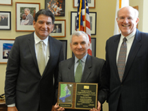
 The American Society for Photogrammetry and Remote Sensing (ASPRS) awarded Senator Jack Reed of Rhode Island the prestigious George E. Brown Jr. Congressional Honor Award in March. James R. Plasker PE ASPRS Executive Director and Gary Florence ASPRS Past-President personally met with Senator Reed and presented him with the George E. Brown Jr. Congressional Honor Award plaque. In addition to a plaque the award consists of an opportunity for ASPRS to sponsor a geospatial sciences presentation to an elementary school secondary school or university of the recipient’s choice in his District or State.
Senator Reed received the award for introducing S. 1938 a FEMA flood mapping reform bill. It included provisions such as acquiring current and accurate elevation data using state-of-the-art mapping technologies (lidar) and services mapping by watershed instead of political boundary and re-establishing the Technical Mapping Advisory Council (TMAC). Reed’s reforms were included in the Federal Emergency Management Agency (FEMA) bill enacted into law in 2012. P.L. 112-141 included reauthorizing the Highway and FEMA Flood programs into the “MAP-21 Act.” The bill also included provisions led by Reed to require National Flood Insurance Program rate maps to use “the most accurate topography and elevation data available.” This bill is unprecedented and is a model for geospatial coordination as well as an innovative way of funding inter-agency and intergovernmental geospatial requirements.
The elevation provisions effectively provide a specific Congressional authorization for the 3D Elevation Program being launched by the U.S. Geological Survey. This is significant because neither the NSDI The National Map nor IFTN were ever specifically authorized by Congress. As a result they either floundered or never got adequate funding. Most importantly Section 100220 develops a funding strategy to leverage and coordinate budgets and expenditures and to maintain or establish joint funding and other agreement mechanisms with other Federal agencies and units of State and local government to share in the collection and utilization of geospatial data among all governmental users and specifically mentions OMB FEMA USGS NOAA & USACE. Section 100121 includes a NAPA study on how FEMA can improve interagency and intergovernmental coordination on flood mapping including a funding strategy to leverage and coordinate budgets and expenditures and establish joint funding mechanisms with other Federal agencies and units of State and local government to share the collection and utilization of data among all governmental users.
The Award was created in honor of the late Congressman George E. Brown Jr. and the contributions he made to advance the benefits of imagery and geospatial information to Society. The George E. Brown Jr. Congressional Honor Award is presented periodically to recognize members of the U.S. Congress whose leadership and personal efforts have advanced the science engineering application education and commerce of imaging and geospatial information.