VOLUME 67, NUMBER 6
PHOTOGRAMMETRIC ENGINEERING & REMOTE SENSING
JOURNAL OF THE AMERICAN SOCIETY FOR PHOTOGRAMMETRY AND REMOTE SENSING
Highlight Article
Introduction
General land cover information is required for many environmental,
land management, and modeling applications. This information may
be derived at a range of spatial scales, which drives the appropriate
usage of the data. Spatially coarse land characterization data
sets, such as those derived from the Advanced Very High Resolution
Radiometer
(AVHRR; e.g. Loveland et al., 1991; Brown et al., 1993) are well
suited for global analyses. However, such coarse-scale data sets
are often of limited value for regional investigations, and are
certainly not appropriate for local land use studies. Similarly,
fine resolution
land cover data sets (e.g. four meter or less spatial resolution)
are very appropriate for local land use planning, but are generally
inappropriate for regional to global analyses.
In late 2000, the U.S.Geological Survey (USGS) EROS Data Center (EDC)
completed the circa 1992 National Land Cover Data set (NLCD). The NLCD,
derived from early 1990s Landsat Thematic Mapper (TM) imagery and other
sources of digital data, represents an intermediate-scale national
land cover data set. The resolution of this data set lends itself to
many regional to national scale investigations, including analyses
of water quality, ecosystem health, wildlife habitat, land cover assessments
and other land management issues. The purpose of this paper is to describe
the characteristics and uses of this data set.
One of the goals in the development of the NLCD was to generate a
reasonably consistent and seamless 30 meter product for the conterminous
United States. The methodology employed to develop the NLCD is analogous
to the database approach originally envisioned by Lauer (1986). The
early developmental stages of the data set have been described elsewhere
(Vogelmann et al. 1998a and b). In addition to the spectral information
provided by the TM, ancillary spatial data were used to improve classification
results, when appropriate. The NLCD may be considered as a replacement/update
to the intermediate-scale Land Use and Land Cover data set (USGS, 1990)
developed in the 1970s and early 1980s.
Materials & Methods TM Data. NLCD is based primarily on 1992 vintage
Landsat 5 Thematic Mapper (TM) data that were purchased and pre-processed
to a common set of specifications for the Multiresolution Land Characteristics
(MRLC) consortium (Loveland and Shaw, 1996). The partner agencies,
which included the USGS, the U.S. Environmental Protection Agency
(EPA), National Oceanic and Atmospheric Administration (NOAA) and
the U.S. Forest Service (USFS), pooled resources to purchase Landsat
TM scenes for each of over 400 path/row locations in the lower 48
states. Land cover classification was carried out by several USGS
groups at different locations and an outside contractor.
Landsat TM data used to develop the NLCD were terrain-corrected using
3-arc-second digital terrain elevation data (DTED; U.S. Geological
Survey, 1993). The TM data were geo-registered to the Albers Equal
Area projection grid using ground control points, resulting in a root
mean square registration error of less than one pixel (30 m). Two or
more TM data sets for each path/row, representing different seasons,
were used to generate the NLCD product. Two or more TM scenes representing
different times of the growing season (e.g. leaf-on and leaf-off) generally
improves upon the quality of land cover information that can be derived
as compared to analysis of a single scene.
Ancillary Spatial Data. In addition to TM data, a
variety of other intermediate-scale spatial data were used to help
develop the NLCD; these included Digital Terrain Elevation Data (DTED)
and derivative DTED products (slope, aspect, shaded relief), population
density data at the census block level (Bureau of the Census, 1991
a and b; 1992), Land Use and Land Cover data (USGS 1990), and digital
National Wetlands Inventory data (NWI; Fish and Wildlife Service, 1996).
Other data sets were used to a lesser extent, and included available
water capacity and organic carbon (0-40 cm depth) data derived from
the State Soil Geographic (STATSGO) Data Base (U.S. Department of Agriculture,
1994), and land cover information derived from various state or national
programs. Land cover data from the USGS Biological Resource Division
Gap Analysis Program (Scott et al., 1996) were used when available.
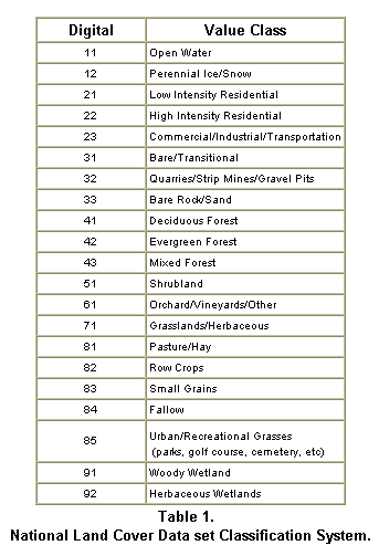
Classification
System. The NLCD classification system (Table 1) provides
a consistent hierarchical approach to defining 21 classes of land
cover across the conterminous United States. The classification approach
merged existing schemes, including the NOAA Coastal Change Analysis
Program (C-CAP) classification protocol (Dobson et al., 1995) and
the Anderson system (Anderson et al., 1976). The intent behind the
classification system is to enable comparison with other sources
of land cover information.
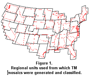
General Classification Methods. Mosaics of leaf-on
(i.e. summer) and leaf-off (i.e. spring) imagery were generated for
each of 31 regional units (based on political administrative units,
contiguity of Landsat scenes and data volume) covering the conterminous
United States (Figure 1). Each unit was classified separately using
one of several methods. In most cases the general thematic approach
was to designate either mosaic (leaf-on or the leaf-off) as the “baseline” data
set, and to use that spectral information as the primary source of
information from which to derive the classification product. The decision
as to which mosaic to use was based on a subjective evaluation of which
appeared to be the “best” mosaic in terms of overall data quality and
information content. Leaf-off mosaics were chosen as baseline data
sets more frequently than leaf-on mosaics. Ancillary spatial information,
including spectral data from the image mosaic representing the other
season, was used to refine or aid in the labeling process. After development
of a first order classification product, a series of recoding operations
were performed to fix obvious misclassifications and to further refine
the classification.
During the initial stages of the project, the primary steps for generating
the NLCD classification product were: (1) Cluster the baseline mosaic
using unsupervised classification. (2) Interpret and label clusters
using aerial photographs. (3) Resolve confused clusters by constructing
logical or threshold models that utilize appropriate ancillary data.
(4) Develop and incorporate information from onscreen digitizing (e.g.
quarries, transitional bare areas). As the project progressed, some
classification teams individualized the approach on a case-by-case
basis. More in-depth methodology for this process has been described
elsewhere (Vogelmann et al., 1998 b). Modifications were based upon
data quality issues, characteristics of the region being analyzed,
and familiarity with other approaches that would facilitate and/or
more readily automate the classification process.
In the case of multiscene mosaics, spectral clusters developed from
unsupervised clustering can be very complex, and a single cluster may
represent many different types of land cover. In these cases, splitting
the clusters into meaningful land cover units via modeling based on
spectral and ancillary data can be quite difficult. Not only are the
thresholds used to make land cover separation important, but the order
of threshold implementation can also have substantial effects on the
land cover estimates. Determining the optimal set of thresholds and
the optimal order of implementation for complex “confused clusters” can
be time consuming and difficult. One approach taken was to use
decision trees to facilitate the modeling process.
Decision trees derive objective, efficient, and ordered thresholds
using non-parametric techniques (Friedl and Brodley 1997 and Hansen
et al. 1996). Decision trees have been successfully used to derive
land cover (Friedl and Brodley 1997) and to identify important data
layers or spectral bands (Hansen et al. 1996; Prince and Steininger
1999). For decision tree training, the image clusters were included
only as an ancillary data set. Multiple decision trees trained with
different data layer set combinations and/or decision tree parameter
options produced multiple land cover maps. Majority land cover from
the multiple land cover maps for each pixel was used as a preliminary
land cover map. Decision trees were also used to help define classification “rules” in
an expert system classifier (ERDAS 1998). The expert system allowed
quick identification of which rules affected which pixels and quick
modification of either rules or rule confidence levels. While it was
apparent that the decision trees maintained a high degree of detail
in the land cover products, the need for visual inspection and “heads
up” on-screen corrections of the preliminary land cover persisted.
In all cases, results were scrutinized in order to ensure comparability
of land cover data among regions and to correct obvious classification
errors. Edge-matching of adjacent mosaics was then performed to yield
a reasonably seamless national-scale product. This was a major task
due to seasonal and interpretation differences that invariably resulted
in thematic seam lines at the boundaries of the mosaics. As the mosaics
were finally pieced together, individual states were extracted using
boundaries defined by the 1:100,000 scale Digital Line Graph series.
The state files were designated “preliminary” and made available to
the user community for review and feedback. Initially, the state land
cover files were available to users who contacted the USGS/EDC Land
Cover Applications Center to gain access to the data. The intent was
to ensure that users understood the “preliminary” nature of the data,
as well as its limitations, and to register the user and solicit feedback
regarding the utility of the data and any problems that were identified.
As feedback was received, it was reviewed and a determination made
if an update was required. In many cases, updates were made, and the
registered users were apprised of the changes.
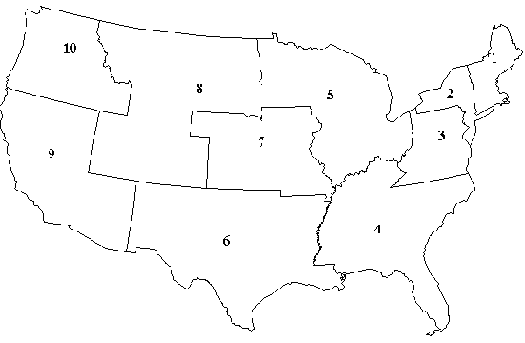
Accuracy Assessment Methods. When all the states
comprising a Federal Region were finalized, the accuracy assessment
(AA) phase was initiated. At this time, the AA for regions 1-4 (Figure
2) are complete, regions 5,7, and 10 are underway, and the remainder
are in the planning stages. The accuracy assessment was based on interpretations
of 1990 vintage aerial photographs acquired by the National Aerial
Photography Program (NAPP). The accuracy assessment of NLCD was achieved
with
1) a probability sampling design;
2) a response design for reference data evaluation; and
3) an analysis procedure for estimation of accuracy parameters.
Fig 2. U.S. Federal Regions
The sampling design incorporated three levels of stratification and a
two-stage cluster sampling protocol (Stehman et al., 2000). Each Federal
region constituted a stratum and was sampled independently. Within each
mapping region, geographic strata were created using 15 x 15 or 30 x
30 minute grid cells, depending on the size of the region. Primary sampling
units (PSU) defined by non-overlapping, interior regions of NAPP were
delineated within these strata. A single PSU was randomly selected from
each grid cell, with all PSU’s having an equal probability of being selected.
All pixels selected within the first-stage
PSU’s were stratified by mapped landcover class, and a simple random sample of
approximately 80 to 100 pixels was selected for each land-cover class.
To obtain reference land cover class labels, each sample (pixel) was identified
on a NAPP aerial photograph. A suite of attributes was collected by photointerpreters,
including primary and alternate landcover label (an alternate reference label
only provided when appropriate), landcover heterogeneity in the vicinity of
the sample unit, and a confidence rating of the photointerpreted landcover
label. For a more detailed discussion on the reference data collection and
evaluation, refer to Yang et al. (2000) and Zhu et al. (2000). For each mapping
region, stratified sampling formulas were applied to estimate the error matrix
cell proportions (Stehman and Czaplewski, 1998), and subsequently, the estimates
of overall and class-specific user and producer’s accuracy (Story and Congalton,
1986). The use of stratified formulas is important because of sampling methods
that have been chosen for the project. Accuracy results were computed through
weighting the cell proportions by the proportion of each land cover within
a given Federal region.
Results and Discussion NLCD products. The NLCD classification product (Figure 3)
provides an overview of the major land cover features for the conterminous
United States.
Figure 3. National Land Cover Data set for the conterminous U.S.
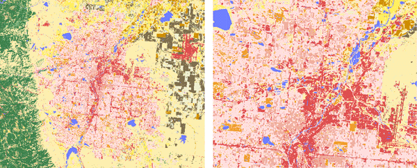
Land cover for larger scale areas located in Colorado (Figure 4) provide information
regard-ing the level of detail typical of the NLCD, with the image to the right
showing full resolution and detail of the data set.
Figure 4. (Left) Denver, Colorado. (Right) Downtown Denver
Colorado (showing full resolution of the National Land Cover Data set).
Refer to figure 3 for color legend
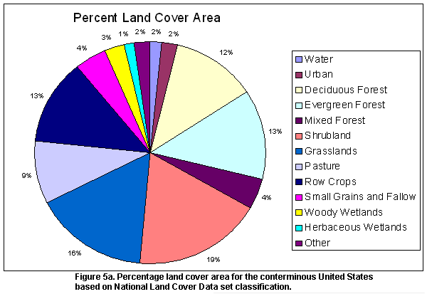
The equal-area projection of the NLCD allows easy area tabulations of the
various land cover classes. Table 2 shows the percentage land cover estimates
derived from raw pixel count for each of the ten U.S. Federal Regions of the
conterminous U.S. This information is also shown graphically for the conterminous
U.S. in Figure 5. At a glance, it can be seen that the four forest classes
(deciduous, evergreen, mixed forest and woody wetlands) make up a significant
proportion of the NLCD, combining for a total of 32.1% of the area of the conterminous
U.S. Agriculture (pasture/hay, row crops, small grains, fallow and orchards/vineyards)
makes up about 26.4% of the surface area of the conterminous U.S. Urban classes
(low and high intensity residential, commercial/industrial/transportation)
account for 2.0 % of the surface area. Land cover area estimates are also available
for each of the 48 conterminous U.S. states, and may be obtained at: http://edcwww.cr.usgs.gov/programs/lccp/natllandcover.html
Reg 1
Reg 2
Reg 3
Reg 4
Reg 5
Reg 6
Reg 7
Reg 8
Reg 9
Reg 10
TOTAL
% Area
Water
2956
1812
1791
8450
10106
10207
3067
7971
2703
2878
51942
1.7
Perenn. Ice Snow
0
0
0
0
0
0
0
330
17
240
587
0.0
Low Int Res.
2297
2657
2954
7482
4739
3820
1487
1182
3585
1494
31697
1.1
Hi Int Res.
272
777
280
2102
2021
1416
646
154
453
9
8129
0.3
Comm/Ind/Trans
899
695
1297
3179
2864
2842
1887
1145
1698
1043
17549
0.6
Bare Rock
143
34
27
369
74
4579
274
13552
19151
4438
42640
1.4
Quarries/ Mines
46
81
615
475
415
320
97
245
260
29
2584
0.1
Transitional
891
44
842
8948
728
1676
62
2020
134
3815
19162
0.6
DeciduousForest
19517
20116
60713
87523
72511
47139
29829
13365
3223
6152
360088
12.0
Evergreen Forest
12315
3448
7090
67340
10086
50761
1819
80228
63623
91210
387920
12.9
Mixed Forest
17309
10350
12790
44868
9556
20235
2486
1789
5614
6853
131850
4.4
Shrubland
190
0
0
479
452
128416
1108
121248
219948
74872
546713
18.2
Orch/ Vineyard
16
0
0
1671
4
45
0
8
4216
627
6587
0.2
Grasslands/Herb
0
0
0
5580
2143
128332
79090
203749
38567
21613
479074
15.9
Pasture/Hay
1254
10534
23163
40879
54929
55645
47852
25618
8237
11416
279527
9.3
Row Crops
3412
2976
6795
50137
124217
52888
86524
42888
6262
3711
379811
12.6
Small Grains
0
0
0
657
2262
24941
21515
39679
3619
10325
102998
3.4
Fallow
0
0
0
0
0
260
1575
20186
43
5604
27667
0.9
Urban/Rec Grass
656
472
224
1668
1738
680
778
283
354
115
6967
0.2
Woody Wetlands
2447
1834
2153
37275
25913
11381
2527
1139
193
550
85412
2.8
Emerg/Herb. Wet.
912
452
1058
8000
7686
10179
2983
4879
730
1104
37982
1.3
Totals
65531
56282
121792
377082
332445
555765
285606
581657
382629
248098
3006887
Table 2. Land Cover Area (Square Miles) for the 10 Federal
Regions of the Lower 48 United States
based on raw pixel counts from the National
Land
Cover Data set 1992.
While many users
will want to retain the full 30-m resolution of the NLCD, some users, such
as those working at the national scale, will find that there are too many pixels
in the original data set for their applications. For these users, files of
smaller size representing condensed derivative versions of conterminous U.S.
land cover have been created from the NLCD. One of these products simply depicts
the dominant land cover class for each square kilometer in the conterminous
U.S. A second type of product developed represents percentage land cover type
for each 1km unit across the conterminous U.S. There are 21 of these 1 km-resolution
data layers, one for each NLCD land cover class. An example showing of percentage
deciduous forest is shown in Figure 6. Each individual file of the 1km-resolution
data sets is approximately 0.09% the size of the original NLCD data set. Thus,
these data layers do not take up huge amounts of computer disk space and are
ideal for efforts that require complex computations and manipulations. These
data sets are especially appropriate for national-scale efforts in which land
cover information is necessary, but not necessarily at the NLCD 30-m resolution.
Currently, these data sets are preliminary; more refined versions are anticipated
(contact USGS/EDC).
Accuracy. Several rules for defining agreement between map
and reference data may be applied given the information collected from NAPP
photos and land cover maps. Comparing results across a range ofagreement protocols
and data sub-sets permits evaluation of the reference data quality and more
thorough investigation of thematic map accuracy (Congalton and Green 1993,
Khorram et al. 1999). In this paper, accuracy results are briefly reported
for the first four regions in the eastern United States combined (see Figure
2) by defining agreement as a match between the primary or alternate reference
land-cover label and the mode land-cover label in a 3x3 pixel window surrounding
the sample. Detailed region specific accuracy assessment results completed
thus far can be obtained at: http://edcwww.usgs.gov/programs/lccp/accuracy and
also from Yang et al. (2001a).
Overall accuracy for the eastern United States was 81% for Anderson Level
I aggregations (i.e. water, urban, barren land, forest, agricultural land,
wetland, rangeland; Anderson et al., 1976), and 60% for all classes (analogous
to Anderson Level II classes). As expected, a significant source of disagreement
between map and reference land-cover labels (approximately 20%) was between
classes that aggregate into a single Anderson Level I class. Other sources
of disagreement were between the forest and agricultural classes, which accounted
for approximately five percent of the error, and between the forested wetland
class (91) and the upland forest classes (41, 42, 43).
At Anderson Level II, notably high commission errors occurred for mines (class
32), hay/pasture (class 81) and high intensity residential (class 22). Not
surprisingly, high intensity residential was most often confused with the other
urban classes (low intensity residential and commercial/industrial). Meanwhile,
hay/pasture was most often confused with row crops (class 82). Mines were often
confused with transitional, hay/pasture and deciduous forest. Some of these
latter discrepancies undoubtedly were related to changing surface conditions
that occurred between image and photograph acquisitions.
Since October, 1999 over 8500 state land cover files have been downloaded
from the USGS EROS Data Center FTP site. The files on the FTP site are generic
binary files (one file for each state) and are available at no charge to data
users. A text file is associated with each binary file, and provides information
on map projection, coordinates, and other parameters. Additionally, the states
in Regions 1-4 are also available on 8 CDROMs. States in Regions 5-10 will
ultimately be available on CDROM. Each CD contains as many contiguous state
files as will fit (e.g. all six New England states are available on one CD).
A total of 31 CDs are required to hold all the NLCD files. As of December 31,
2000, over 200 CDs (600 files) have been purchased from the following web site: http://edcwww.cr.usgs.gov/programs/lccp/nlcd.jsp.
All users of
the NLCD are advised of the intended applications and limitations of the NLCD.
The data set was designed and implemented to meet the broad requirements of
federal agencies for a consistent national land cover data set. That is, the
procedures and available resources dictated that it was not possible or feasible
to spend a great deal of effort to ensure the accuracy and integrity of the
classification results at local scales. Further, as outlined above, the accuracy
assessment is being carried out on the basis of large federal regions and so
the accuracy of the NLCD at local levels is unknown. Therefore, users are advised
that the NLCD is not recommended for local scale analyses. We recognize that
some users will use the data for local purposes due to lack of other available
options. These users are advised to scrutinize the NLCD in their study area
to verify that there are no major errors in the classification. This assumes
that the user has a good understanding of land cover in their study area. Feedback
from users confirms this advisory. Some users report very good agreement in
their local areas, whereas others report problems.
Since the data have been available, the USGS/EDC Land Cover Applications Center
has compiled a database of users and their applications. The goal is to gather
user information to better understand the need for land cover data. To date,
over 500 people have registered as users of the NLCD. The following information
was derived from that database.
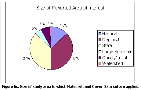
Users and Applications of NLCD. As expected, Federal and State agencies along
with Universities are the major users of the NLCD, but many, non-governmental
organizations (NGOs), commercial and local agencies are also showing interest
in the NLCD (see Figure 5). The reported size of study areas to which NLCD
data are being applied (Figure 5) indicates that most, but not all users are
using NLCD for large area assessments. Approximately 8% of the users are using
the data for relatively small areas (county size or smaller).
The NLCD is being used for a wide range of applications (Table 3). While some
users appear to push the limits of the data, we have not ascertained whether
this group scrutinized the data as recommended and were satisfied with what
they found. Many of these users report there is no other source of data.
Limitations and Reflections
The NLCD provides excellent regional to national-scale overviews of early 1990s
vintage land cover of the United States. During the course of developing
the data set, we have become very familiar with some of the strengths and
weaknesses of the data set. These come under different headings, and are
described below.
Accuracy. While the 80% accuracy level achieved for the NLCD
at Anderson Level 1 is a reasonable value considering the scope of the project,
the level of accuracy for the Anderson Level 2 type classes (60%) is lower
than anticipated. There are a number of variables that affect accuracy levels,
and discussion of some of these as they pertain to NLCD is warranted.
One source of Anderson level 2-type error relates to the level of class distinctness.
Some groups of classes fall on a continuum, grading from one class to another
(both in the field as well as spectrally). The forest classes and residential
classes are good examples of this as they grade from one class to another with
no definite demarcation between them (e.g. deciduous to mixed to evergreen;
low intensity to high intensity residential). While the definitions of these
classes include percentage thresholds as cutoff values (e.g. low intensity
residential is characterized by having 0-75% built-up material, and high intensity
residential has 75-100% built-up material), the classes are not particularly
well-defined, especially near the threshold value. Yet unless the accuracy
values are thoroughly scrutinized, a point that is labeled as “high-intensity
residential” that has 72% built-up material will simply be a misclassification
contributing to error.
Another source of error relates to interpretability and quality of reference
material used in the accuracy assessment. In this investigation, AA was accomplished
using NAPP photography. It is noteworthy that the forested wetland class had
a relatively high error based upon the AA, yet the original source for much
of the forested wetlands information was NWI. Wetlands for NWI were originally
delineated by interpretation of air photos. The NWI data in turn were relied
upon heavily to delineate wetlands for NLCD. Yet the air photo validation of
forested wetlands of NLCD indicated high levels of “error.” The discrepancies
resulted from (1) differences in photointerpreters, and/or (2) the fact that
the photographic materials used for NLCD were not ideal for discriminating
forested wetlands (whereas the photos used for NWI were better). In either
case, it is apparent that there is error associated with the photointer-pretation
phase of the accuracy assessment that adds to classification “error.” Quality
of air photos, which includes year and season of photo acquisition, may be
a major factor influencing the accuracy assessment error for other classes
as well, especially those that have a propensity to change intra- and inter-annually
(e.g. agricultural crops).
It is important that users of the NLCD carefully evaluate the accuracy values
in the context of their particular applications. Those users who do not need
Anderson Level 2 type class information may wish to combine classes into an
Anderson Level 1-type of a product, and thus work with land cover data with
higher accuracies that will enhance the integrity of their results. Conversely,
users working with the NLCD data in spatial modeling capacities may wish to
keep the data in the 21-class form. These users may recognize that while there
is error associated with the classification product, there may also be high
levels of uncertainly associated with the models that they are running, and
that some information for given classes is better than none.
It should also be kept in mind that scaling issues affect classification accuracies,
with a general trend of increasing accuracies with coarser levels of spatial
aggregations of pixels. For instance, higher levels of error are associated
with these error assessments conducted at the single pixel level than at the
3x3 pixel level. Many users do not need the NLCD at the level of spatial detail
provided, and will find it beneficial to spatially aggregate to the scale appropriate
for their application. While we do not know the levels of accuracy associated
with the 1 km NLCD products, we are reasonably certain that the accuracy levels
of these data sets will be high enough for many national-scale applications.
Flexibility. Users often desire more land cover classes than
NLCD, but they need to recognize that increasing the number of classes tends
to exponentially increase the level of effort in creating the land cover classification
product. In addition, higher numbers of classes generally result in higher
levels of error. In spite of these observations, we recognize that there is
a need within the user community for products that provide more thematic information
than is currently provided by NLCD. Certainly there is more land cover information
that can be gleaned from the Landsat data and ancillary data sets than provided
by NLCD. Standard classifications such as those done to generate NLCD tend
to generalize and simplify the landscape into a set number of discrete units,
and much potentially useful information tends to be lost in the process.
One of the goals with future work will be to generate a land characteristics
database at 30 m resolution that provides users with more capabilities towards
tailoring products that will fit with their applications. Techniques are currently
being developed for this, and will be implemented during “MRLC 2000” when a
new National Land Cover Database will be generated for the entire United States
using 2000 vintage Landsat data. One of the goals of this research will be
to provide more quantitative information for selected continuous variables
(e.g. canopy closure, impermeable surfaces). In addition, it is anticipated
that users will have access to more intermediate data layers (i.e. pre-classification
derivative products) that will be useful for deriving specific land cover variables
appropriate for their applications that are not included in the final NLCD
data sets.
Quality of Source Data. High quality land cover products
can be derived only when input data are also of high quality. Generally, the
Landsat 5 TM data acquired by the MRLC were of high quality from the standpoint
of cloud and haze coverage. However, many of the data sets were sub-optimal
in terms of seasonality. Many land cover features are much easier to map accurately
using remotely sensed data sets from the appropriate time of year. For instance,
hay/pasture is easier to discriminate from other types of land cover in early
spring rather than mid-summer. While early spring and midsummer TM data sets
were targeted for developing the NLCD, the data sets from the optimal time
periods were often not available due to cloud contamination. In addition, it
was often difficult to ascertain what “optimal” time periods were for each
scene. Thus, during the scene-selection phase of the project, there were two
confounding issues: (1) lack of data from the appropriate time(s) of year and
(2) lack of knowledge as to the time frames of optimal land cover separability
for each scene. Determination of the date to be used was generally subjective,
and was based on our somewhat limited understanding of phenological patterns
and opinion as to what time periods would give us the best land cover separability.
With the potential of using both Landsat 5 and 7 data for the next national
mapping effort, the issue of clouds adversely affecting data availability may
not be as great a problem as during the first effort. The two satellites are
offset by eight days, and thus there will be twice as many opportunities to
acquire cloud-free data throughout the growing season as during the first mapping
effort. While the primary source of data for land cover mapping will be from
Landsat 7 ETM+ data, it should be possible to augment the database with Landsat
5 TM data when necessary. Both TM and ETM+ data have been shown to provide
similar information from an applications standpoint (Vogelmann et al., 2001),
and with some exceptions and modifications, it should be possible to use the
two sources of data interchangeably.
The other issue, lack of knowledge as to the time frames of optimal land cover
separability, has been the focus of research since the completion of NLCD.
In brief, it has been determined that use of the high temporal resolution data
provided by AVHRR in conjunction with NLCD-derived land cover information provides
useful information regarding optimal time periods for Landsat data acquisitions.
Briefly, seasonal AVHRR-derived Normalized Difference Vegetation Index (NVDI)
data were obtained for the dominant NLCD-derived land cover types for each
path and row or mapping zone. Plots of AVHRR-derived NDVI versus date were
developed for each major type of land cover for each path/row or mapping zone.
Comparisons of the plots were then done to determine the three best dates for
separating as many of the dominant types of land cover for each path/row as
possible. Further details are provided in Yang et al. (2001b). This information
is being used to target dates for scene acquisition for the next mapping effort.
It is anticipated that three scenes, representing different seasons, will be
acquired for each scene for MRLC 2000.
Conclusions
The completion of NLCD has provided a 1990s vintage land cover data set for
the conterminous United States. In addition to being more current, this product
is spatially improved over the Land Use and Land Cover data set (USGS, 1990).
Since being released, the usage level of this data set has been high, with
many investigators using the data set for a multitude of applications. This
underscores the importance of the data set, and also implies that updated
data sets need to be developed on a regular basis. Not only does the user
community require current land cover, but they also require accurate and
detailed information that can potentially be used for monitoring purposes.
While the data set provides an excellent overview of the nation’s land cover
patterns, it needs to be emphasized that this was the first of its kind for
the conterminous United States, and that expectations for the quality of
such a data set need to be tempered with reality. While we believe that this
data set will fit the needs of many who work at the regional to national
scales, we do not believe that the data set is particularly appropriate for
local applications without modification. Conversely, the data may serve as
a first-order land cover data set from which more refined data sets can be
developed at the local level. We are cognizant of the need for more land
cover information than provided by NLCD, and are currently working on methods
to accommodate this need for the next national mapping effort. We will continue
to refine methods to create accurate land cover projects, which will include
continued research and development activities.
Acknowledgments. This work was performed in part by the Raytheon
Corporation under U.S. Geological Survey Contract 1434-CR-97-40274.
Authors
James E. Vogelmann1, Stephen M. Howard1, Limin Yang1,
Charles R. Larson1, Bruce K. Wylie1 and Nick Van Driel2 1Raytheon ITSS, EROS Data Center, Sioux Falls, SD 57198 2U.S. Geological Survey, EROS Data Center, Sioux Falls, SD 57198
References
Anderson, J.F., E.E. Hardy, J.T. Roach, and R.E. Witmer, 1976. A land use and
land cover classification system for use with remote sensor data, U.S.
Geological Survey Professional Paper 964, 28 pp.
Brown, J.F., T.R. Loveland, J.W. Merchant, B.C. Reed, and D.O. Ohlen, 1993.
Using multisource data in global land cover characterization: concepts, requirements
and methods. Photogrammetric Engineering and Remote Sensing, 59:977—987.
Bureau of the Census, 1991a. Census of population and housing, 1990, public
law 94-171 data (United States) (machine readable data files), The U.S.
Bureau of the Census (producer and distributor), Washington, D.C.
Bureau of the Census, 1991b. Census of population and housing, 1990, public
law 94-171 data, on-line documentation (United States), The U.S. Bureau
of the Census, Washington, D.C.
Bureau of the Census, 1992. TIGER/Line Files, (machine readable data files), The
Bureau of the Census (producer and distributor), Washington, D.C.
Congalton, R. and K. Green, 1993. A practical look at sources of confusion
in error matrix generation. Photogrammetric Engineering and Remote Sensing, 59:641-644.
Dobson, J.E., E.A. Bright, R.L. Ferguson, D.W. Field, L.L. Wood, K.D. Haddad,
H. Iredale, J.R. Jensen, V.V. Klemas, R.J. Orth, and J.P. Thomas, 1995. NOAA
Coastal Change Analysis Program (C-CAP): guidance for regional implementation, NOAA
Technical Report NMFS 123, U.S. Department of Commerce, Seattle, Washington.
Friedl, M.A. and C.E. Brodley, 1997. Decision tree classification of land
cover from remotely sensed data. Remote Sensing of Environment, 61:399-409.
Hansen, M., R. Dubayah and R. Defries, 1996. Classification trees: an alternative
to traditional land cover classifiers. International Journal of Remote
Sensing, 17:1075-1081.
Khorram, S., G. Biging, D. Colby, R. Congalton, J. Dobson, R. Ferguson, M.
Goodchild, J. Jensen, and T. Mace, 1999. Accuracy Assessment of Remote
Sensing-derived Change Detection. Monograph. American Society of Photogrammetry
and Remote Sensing, Bethesda, MD, 64 pp.
Lauer, D.T, 1986. Applications of Landsat data and the data base approach. Photogrammetric
Engineering and Remote Sensing, 52: 1193-1199.
Loveland, T.L., J.W. Merchant, D.O. Ohlen, and J.F. Brown, 1991. Development
of a landcover characteristics database for the conterminous U.S. Photogrammetric
Engineeering and Remote Sensing, 57:1,453-1,463.
Loveland, T.L. and D. M. Shaw, 1996. Multiresolution land chracterization:
building collaborative partnerships, In Gap Analysis: A Landscape Approach
to Biodiversity Planning (eds. J.M. Scott, T. Tear, and F. Davis),
Proceedings of the ASPRS/GAP Symposium, Charlotte, NC, (National Biological
Service, Moscow, ID), pp. 83-89.
Prince, S.D. and M.K. Steininger, 1999. Biophysical stratification of the
Amazon basin. Global Change Biology, 5:1-22.
Scott, J.M., T.H. Tear, and F.W. Davis (eds.), 1996. Gap Analysis.
A Landscape Approach to Biodiversity Planning, American Society for
Photogrammetry and Remote Sensing, Bethesda, MD, 320 pp.
Stehman, S.V. and R.L. Czaplewski, 1998. Design and analysis for thematic
map accuracy assessment: Fundamental principles. Remote Sensing of Environment, 64:331-344.
Stehman, S.V., J.D. Wickham, L. Yang, and J.H. Smith, 2000. Assessing the
accuracy of large-area land cover maps: Experiences from the Multi-resolution
Land-cover Characteristics (MRLC) Project. Proceedings of the 4th International
Symposium on Spatial Accuracy Assessment in Natural Resources and Environmental
Sciences, Delft University Press, The Netherlands, 601-608.
Story, M. and R.G. Congalton, 1986. Accuracy assessment: A user’s perspective, Photogrammetric
Engineering and Remote Sensing, 52:397-399.
U.S. Department of Agriculture, 1994. State Soil Geographic (STATSGO) Data
Base, Data Use Information, United States Department of Agriculture Miscellaneous
Publication Number 1492.
U.S. Fish and Wildlife Service, 1996. National Wetlands Inventory (NWI)
Metadata, U.S. Fish and Wildlife Service, National Wetlands Inventory,
St. Petersburg, Florida.
U.S. Geological Survey, 1990. Land use and land cover digital data from 1:250,000-
and 1:1,000,000-scale maps, Data User’s Guide 4, Reston, Virginia,
Department of the Interior, U.S. Geological Survey, 33 pp.
U.S. Geological Survey, 1993. U.S. GeoData digital elevation models, Data
User’s Guide 5, Reston, Virginia, Department of the Interior, U.S. Geological
Survey, 51 pp.
Vogelmann, J.E., D. Helder, R.A. Morfitt, M.J. Choate, J.W. Merchant, and
H. Bulley, 2001. Effects of Landsat 5 TM and Landsat 7 ETM+ radiometric and
geometric calibrations and corrections for landscape characterization, Remote
Sensing of Environment, in press.
Vogelmann, J.E., T.L. Sohl, and S.M. Howard, 1998. Regional characterization
of land cover using multiple sources of data, Photogrammetric Engineering
and Remote Sensing, 64:45-57.
Vogelmann, J.E., T.L. Sohl, P. V. Campbell, and D.M. Shaw, 1998. Regional
land cover characterization using Landsat Thematic Mapper data and ancillary
data sources. Environmental Monitoring and Assessment, 451:415-428.
Yang, L., S.V. Stehman, J.D. Wickham, J.H. Smith, and N.J. Van Driel, 2000.
Thematic validation of land cover data of the eastern United States using aerial
photography: feasibility and challenges. Proceedings of the 4th International
Symposium on Spatial Accuracy Assessment in Natural Resources and Environmental
Sciences, pp. 747-754.
Yang, L., S. Stehman, J. Smith, and J. Wickman, 2001a. Thematic Accuracy of
MRLC Land Cover for the Eastern United States, Remote Sensing of Environment, in
press.
Yang, L., C. Homer, K. Hegge, B. Wylie, and B. Reed, 2001b. A Landsat 7 scene
selection strategy for national land cover and land use characterization. In
prep.
Zhu, Z, L. Yang, S.V. Stehman, and R.L. Czaplewski, 2000. Accuracy assessment
for the U.S. Geological Survey regional land cover mapping program: New York
and New Jersey Region, Photogrammetric Engineering and Remote Sensing, 66:1425-1435.
 Classification
System. The NLCD classification system (Table 1) provides
a consistent hierarchical approach to defining 21 classes of land
cover across the conterminous United States. The classification approach
merged existing schemes, including the NOAA Coastal Change Analysis
Program (C-CAP) classification protocol (Dobson et al., 1995) and
the Anderson system (Anderson et al., 1976). The intent behind the
classification system is to enable comparison with other sources
of land cover information.
Classification
System. The NLCD classification system (Table 1) provides
a consistent hierarchical approach to defining 21 classes of land
cover across the conterminous United States. The classification approach
merged existing schemes, including the NOAA Coastal Change Analysis
Program (C-CAP) classification protocol (Dobson et al., 1995) and
the Anderson system (Anderson et al., 1976). The intent behind the
classification system is to enable comparison with other sources
of land cover information.
 While many users
will want to retain the full 30-m resolution of the NLCD, some users, such
as those working at the national scale, will find that there are too many pixels
in the original data set for their applications. For these users, files of
smaller size representing condensed derivative versions of conterminous U.S.
land cover have been created from the NLCD. One of these products simply depicts
the dominant land cover class for each square kilometer in the conterminous
U.S. A second type of product developed represents percentage land cover type
for each 1km unit across the conterminous U.S. There are 21 of these 1 km-resolution
data layers, one for each NLCD land cover class. An example showing of percentage
deciduous forest is shown in Figure 6. Each individual file of the 1km-resolution
data sets is approximately 0.09% the size of the original NLCD data set. Thus,
these data layers do not take up huge amounts of computer disk space and are
ideal for efforts that require complex computations and manipulations. These
data sets are especially appropriate for national-scale efforts in which land
cover information is necessary, but not necessarily at the NLCD 30-m resolution.
Currently, these data sets are preliminary; more refined versions are anticipated
(contact USGS/EDC).
While many users
will want to retain the full 30-m resolution of the NLCD, some users, such
as those working at the national scale, will find that there are too many pixels
in the original data set for their applications. For these users, files of
smaller size representing condensed derivative versions of conterminous U.S.
land cover have been created from the NLCD. One of these products simply depicts
the dominant land cover class for each square kilometer in the conterminous
U.S. A second type of product developed represents percentage land cover type
for each 1km unit across the conterminous U.S. There are 21 of these 1 km-resolution
data layers, one for each NLCD land cover class. An example showing of percentage
deciduous forest is shown in Figure 6. Each individual file of the 1km-resolution
data sets is approximately 0.09% the size of the original NLCD data set. Thus,
these data layers do not take up huge amounts of computer disk space and are
ideal for efforts that require complex computations and manipulations. These
data sets are especially appropriate for national-scale efforts in which land
cover information is necessary, but not necessarily at the NLCD 30-m resolution.
Currently, these data sets are preliminary; more refined versions are anticipated
(contact USGS/EDC).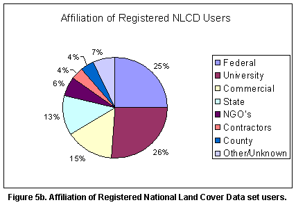
 All users of
the NLCD are advised of the intended applications and limitations of the NLCD.
The data set was designed and implemented to meet the broad requirements of
federal agencies for a consistent national land cover data set. That is, the
procedures and available resources dictated that it was not possible or feasible
to spend a great deal of effort to ensure the accuracy and integrity of the
classification results at local scales. Further, as outlined above, the accuracy
assessment is being carried out on the basis of large federal regions and so
the accuracy of the NLCD at local levels is unknown. Therefore, users are advised
that the NLCD is not recommended for local scale analyses. We recognize that
some users will use the data for local purposes due to lack of other available
options. These users are advised to scrutinize the NLCD in their study area
to verify that there are no major errors in the classification. This assumes
that the user has a good understanding of land cover in their study area. Feedback
from users confirms this advisory. Some users report very good agreement in
their local areas, whereas others report problems.
All users of
the NLCD are advised of the intended applications and limitations of the NLCD.
The data set was designed and implemented to meet the broad requirements of
federal agencies for a consistent national land cover data set. That is, the
procedures and available resources dictated that it was not possible or feasible
to spend a great deal of effort to ensure the accuracy and integrity of the
classification results at local scales. Further, as outlined above, the accuracy
assessment is being carried out on the basis of large federal regions and so
the accuracy of the NLCD at local levels is unknown. Therefore, users are advised
that the NLCD is not recommended for local scale analyses. We recognize that
some users will use the data for local purposes due to lack of other available
options. These users are advised to scrutinize the NLCD in their study area
to verify that there are no major errors in the classification. This assumes
that the user has a good understanding of land cover in their study area. Feedback
from users confirms this advisory. Some users report very good agreement in
their local areas, whereas others report problems.