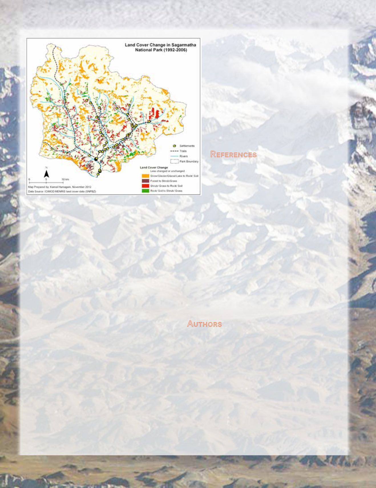
More generally, the total acreage classified as Forest declined
by approximately ten percent during the study period (Figure 7).
However, this figure masks the true rate of forest loss because
of the spatial pattern—in the lower elevations where humans
can easily access timber, there is a near total loss of forest cover
and a large increase in grass cover; but in higher, more remote
locations, there is an increase in vegetative productivity as the
climate warms and growing season lengthens (Figures 6 and 7).
The pattern of disturbance is most pronounced in the valleys
with easiest access and thus highest human usage. However, in
the high elevations, there is a large increase in area classified as
forest or woodland as trees move into former shrub/grasslands
and as grass moves into former glaciated lands.
While our findings are largely preliminary and our
interdisciplinary work in the region is ongoing, we can surmise
that social factors including political conflict, the difficulty to
enforce parkmanagement strategies, increasing tourist demand,
and consequent natural resources exploitation contribute to
explaining some of the changes and conversions in forested
area. It appears that proximal and distal human-induced
changes might be overwhelming any potentially beneficial
climate change impacts on growing conditions or the length of
the growing season and subsequent high elevation re-greening.
These findings are supported both by recent literature (IPCC,
2013) as well as by data gathered from our semi-structured
interviews with locals. Although a growing consideration for
land managers, the long-term development and implementation
of region-specific mitigation and adaptation practices may
currently lie out of their immediate control. However, better data
from satellite observations and socio-economic surveys
can continually inform more effective management
and tourism practices. We hope that our collaborative
work in the region might ultimately help alleviate the
rate of deterioration of Himalayan ecosystems and
contribute to improved human livelihoods. The ACSP
will continue working in these harsh but beautiful
environments and we welcome collaborators from
varied disciplines as this work requires a healthy
dose of interdisciplinarity in addition to land change
scientists (
).
R
eferences
Baral, N and J T Heinen, 2006. The Maoist people’s
war and conservation in Nepal.
Politics and the Life
Sciences,
24(1-2):2-11.
IPCC, 2013. Summary for Policymakers. In: Climate
Change 2013: The Physical Science Basis. Contri-
bution of Working Group I to the Fifth Assessment
Report of the Intergovernmental Panel on Climate Change
[Stocker, T.F., D. Qin, G.-K. Plattner, M. Tignor, S.K. Al-
len, J. Boschung, A. Nauels, Y. Xia, V. Bex and P.M. Midg-
ley (eds.)]. Cambridge University Press, Cambridge, United
Kingdom and New York, NY, USA.
Schmitt, C., J. All, R. Cole, A. Celestian, and W.P. Arnott, 2014.
The Remote Detection of Black Carbon on Tropical Glaciers.
Photogrammetric Engineering & Remote Sensing. 80(5):385-
390
Yonzon, P., 2004. Threats to Nepal’s Protected Areas.
Parks
14(1):35-39
A
uthors
John All
, Department of Geography and Geology, Western
Kentucky University; Executive Director, American Climber
Science Program
Narcisa Pricope
, Department of Geography and Geology ,
University of North Carolina Wilmington
Kamal Humagain
, Department of Natural Resource
Management, Texas Tech University
604
July 2014
PHOTOGRAMMETRIC ENGINEERING & REMOTE SENSING
Background image courtesy of International Space Station using a
Kodak DCS760 digital camera and a 800-mm lens on January 28, 2004.
Image provided by the Earth Observations Laboratory, Johnson Space
Center.
Figure 7: Land Cover Change in Sagarmatha National Park (1992-2006).


