906
December 2016
PHOTOGRAMMETRIC ENGINEERING & REMOTE SENSING
INDUSTRY
NEWS
To have your press release published in
PE&RS
, contact Rae Kelley,
.
ANNOUNCEMENTS
is pleased to announce a high-performance
scanner update to its innovative line of airborne laser terrain
mappers, the
ALTM™. The Galaxy’s scan effi-
ciency has been engineered to deliver an additional 30% boost
to its area coverage rates. When coupled with its innovative
SwathTRAK™ and PulseTRAK™ technologies, collection effi-
ciencies exceeding 70% are possible.
According to Michael Sitar, Teledyne Optech’s Airborne
Business Manager, “Operational cost reduction is a key driv-
er for our clients. This new enhancement releases underlying
performance in a scanner design to enable significant increases
in scan velocity and scan product. This translates to improved
XY point distribution at higher laser PRF sample rates, faster
aircraft speeds and wider scan FOVs, as well as dramatic in-
creases in point density at lesser FOVs.”
The Galaxy is a giant leap forward in productivity and technol-
ogy innovation. Central to the Galaxy‘s performance capability
is a series of unique technology innovations and high-productiv-
ity feature sets that include SwathTRAK™ and PulseTRAK™.
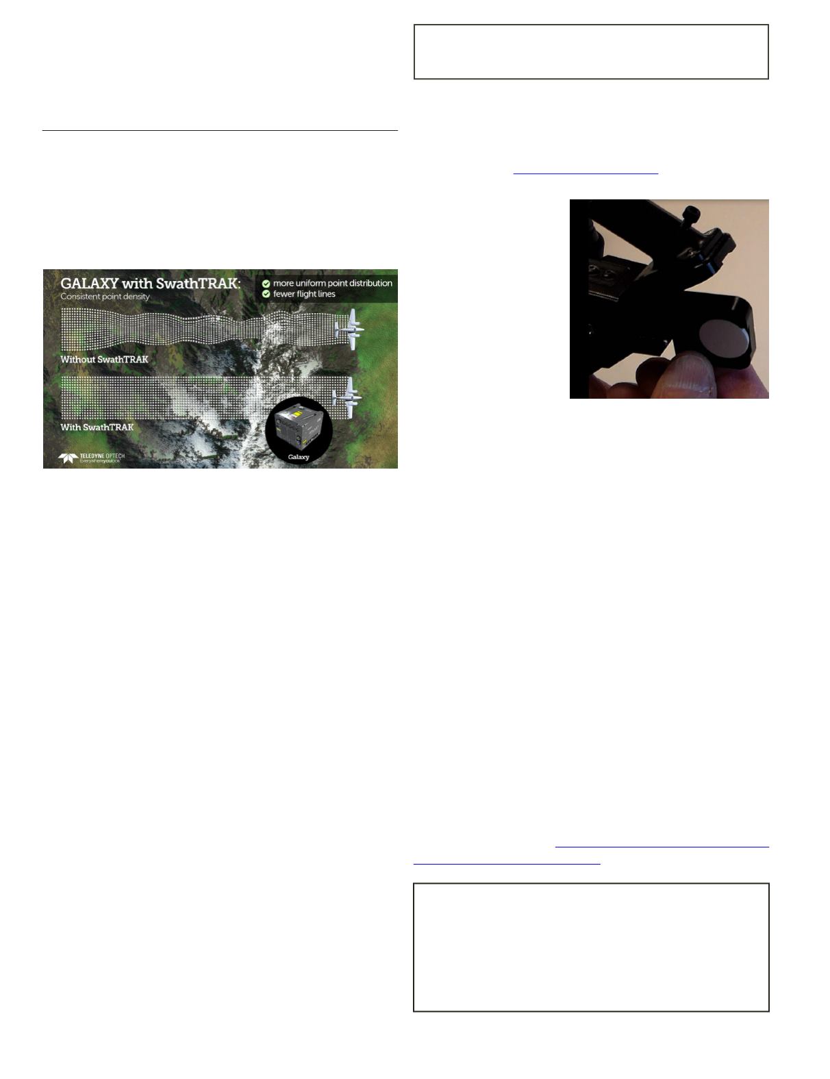
leverages a programmable galvanometric
scanner by dynamically adjusting the scan FOV during flight
and data acquisition, enabling fixed-width data swaths even
in variable terrain. The advantage: fewer flight lines and more
consistent point distribution, whether on hill peaks or valley
bottoms, compared to traditional fixed-FOV sensors.
enables a truly continuous operating enve-
lope, thereby solving the multipulse challenge of data cover-
age gaps and density variation in the multipulse transition/
blind zones. This gives surveyors the ability to use very high
laser pulse rates and generate high point density in variable
terrain, without the need for complex flight planning.
Boasting the same ultra-compact form factor as the
award-winning ALTM™ Orion sensor platform for tier 2 UAV,
heli-pod, gyro-stabilized or fixed-platform installations, the
Galaxy also maintains the same exceptional survey-grade data
precision and accuracy for the highest quality data sets in the
industry. Whether it is high-altitude, wide-area mountain sur-
veys above 4000 m AGL, or low-altitude corridor mapping ini-
tiatives, the Galaxy‘s superior dynamic range and exceptional
small-target detection provides maximum application flexibili-
ty with no compromises in collection efficiency or data quality.
Find out more at
.
Scan and identify in-
vasive plants with the
PSR+ —
The PSR+ is a
rugged and reliable field
portable spectroradiom-
eter that can be used in
the identification and
mapping of the distri-
bution of invasive plant
species. Equipped with
a leaf clip for field plant
sampling, the PSR+ al-
lows a researcher to col-
lect a large number of high resolution scans of plant species
and then use EZ-ID sample identification software with the
Custom Library Builder module to separate native plants from
invasive species even at an immature stage.
The Spectral Evolution leaf clip has a unique design that in-
cludes a built-in white reference and keeps the ILM-105 light
source away from your sample. The ILM-105 is attached to the
PSR+ using a rail system to keep it removed from the sample
leaf. You can take high resolution/high sensitivity scans with-
out heat affecting your leaf sample. The result is consistent
lighting for scans without side effects.
The PSR+ has no moving optical parts for excellent field
ruggedness and stability. Used with the GETAC microcomput-
er, it allows a researcher to take digital pictures, record voice
notes, include GPS coordinates, and see the scans on its sun-
light readable display. All data is saved with the spectra in an
ASCII file for use with third party software.
Optional EZ-ID sample identification software allows you
to create your own library of spectra for different plant spe-
cies. You can add spectra depicting invasive plants at differ-
ent growth stages along with spectra of native plants to make
discrimination easier. Faster and more accurate identification
will help better control the spread of invasive plants and check
the growth and health of native species in the same area.
For more information:
CORRECTION
There was a misprint on the Table of Content page in
the November issue of
PE&RS
. The Highlight Article
“Compressed Geospatial Image Asset Handling with
Express Server”
was authored by Glen Thompson, Don
Johnson, and Jeffrey M. Young from LizardTech.


