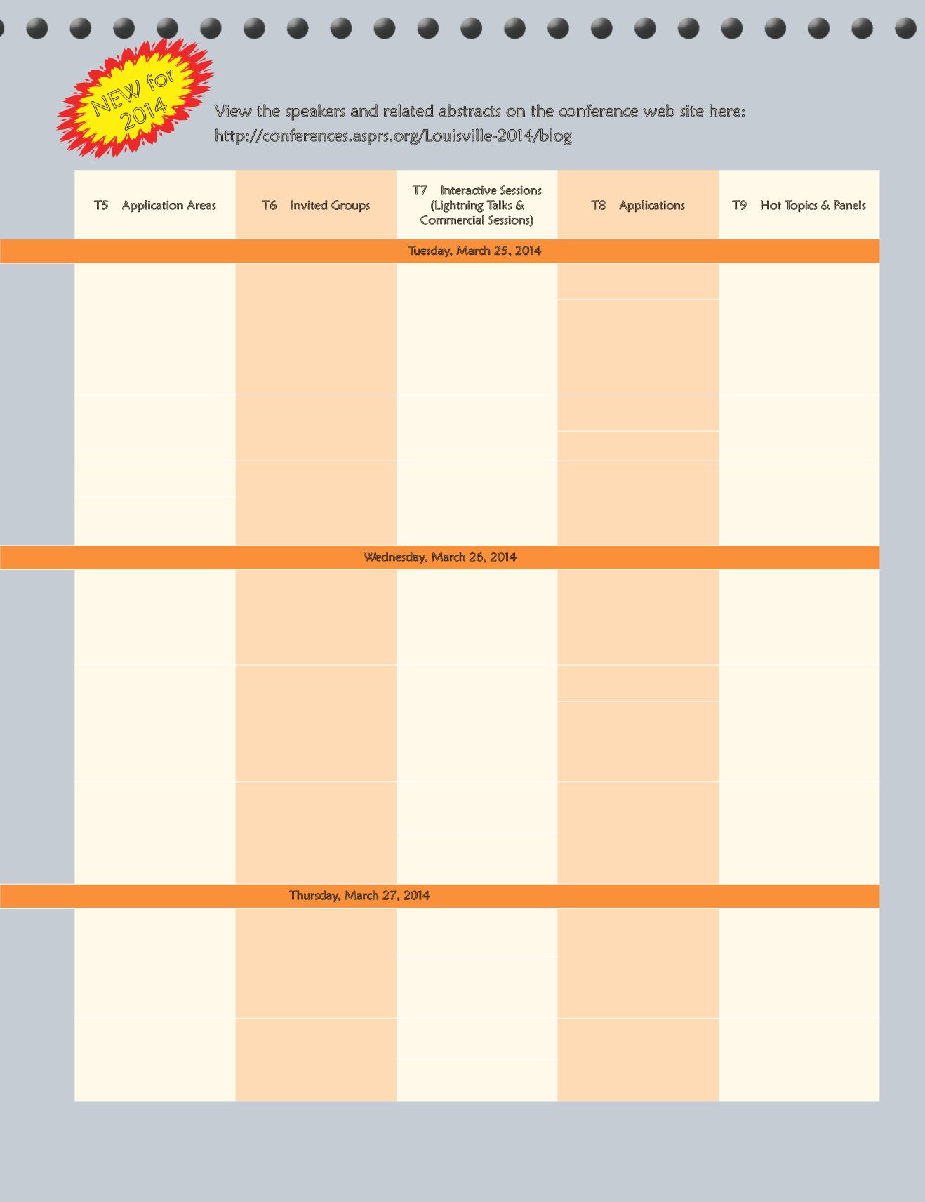
T5 – Application Areas
T6 – Invited Groups
T7 – Interactive Sessions
(Lightning Talks &
Commercial Sessions)
T8 – Applications
T9 – Hot Topics & Panels
Tuesday, March 25, 2014
3D Landscape and Building
Reconstruction Using
LiDAR
NGA UnClassified Session -
Topic To be Announced
Lightning - LiDAR
Data Processing and
Classification
SAC SPECIAL SESSION -
Geospatial Semantics 101
EDUCATION COMMITTEE
SPECIAL SESSION -
Geospatial Education
Initiatives in Kentucky -
Decades-Old, Overnight
Success Stories
SPECIAL SESSION - Littoral
Characterization for
Safe and Free Maritime
Navigation
NGA UnClassified Session -
Topic To be Announced
COMMERCIAL - Emerging
Technology Services
Hydrology and Water
Quality
Geospatial Data Quality
Spatial Dynamics of Coastal
Environments
NGA UnClassified Session -
Topic To be Announced
Lightning - Land Use/
Land Cover and Change
Detection
Land Use and Land Cover
Change in Africa and Asia
New ASPRS Mapping
Accuracy Standards for
Digital Geospatial Data
Wednesday, March 26, 2014
Apps, LiDAR and Web
Imagery for Disaster
Response
JACIE/ASPRS COMBINED
- Civil and Commercial
Imagery Viewpoints
from JACIE Government
Agencies and Keynote
Speakers
Lightning - Advancements
in Radar and Image
Processing/ Time Series
Analysis
Geospatial Analysis for
Wildlife and Conservation
PANEL - Future Landsat
Data Needs a the Local and
State Levels
Hydrology and Water
Quality
Applications of NASA Earth
Observations - the NASA
DEVELOP Program
SPECIAL SESSION
LIGHTNING TALK:
Applications of NASA Earth
Observations - the NASA
DEVELOP
Feature Extraction for
Infrastructure
SPECIAL SESSION OF THE
RSAD CLIMATE CHANGE
COMMITTEE - Extreme
Weather Monitoring with
Remote Sensing
Soil Surface and Subsurface
Applications in Remote
Sensing
COMMERCIAL SESSION
- Modeling Forest and
Shrubland Conditions
SPECIAL SESSION - The
Geospatial Community and
Open Source Software
HOT TOPIC/
PROCUREMENT
GUIDELINES - Attracting
Returning Military to the
Geospatial Workforce
Lightning - Geospatial
Analysis, Monitoring and
Modeling
Thursday, March 27, 2014
Urban Night Light and Gas
Flare Mapping
COMMERCIAL - Canopy
Structure
SAC SPECIAL SESSION -
Education and Professional
Development Council/
Education and Professional
Practice Committee
Geospatial Education and
Outreach
PANEL - Operational Space
Imaging Systems, Advances,
Calibration and Standards
Lightning - Multi-Sensor
Data Integration and High
Resolution Satellite Imagery
Geospatial Data and
Services
JACIE/ASPRS COMBINED
- Landsat 8 Data Quality:
One Year On-Orbit
Planetary Photogrammetric
Mapping
YPC SPECIAL SESSION -
Mentoring Through ASPRS:
The Beta Program
Lightning - Feature
Extraction
View the speakers and related abstracts on the conference web site here:
NEW for
2014
PHOTOGRAMMETRIC ENGINEERING & REMOTE SENSING
February 2014
131


