PHOTOGRAMMETRIC ENGINEERING & REMOTE SENSING
June 2015
427
I
dentifying
O
pportunities
Discussions were held with teachers to identify topics
taught in their classrooms that allowed for the integra-
tion of Landsat and other remotely sensed data. Fol-
low-up visits and discussions were held to evaluate the suit-
ability for incorporating Landsat images in each unit. For ex-
ample, when different farming methods were being taught,
Landsat images showing cropping and irrigation practices
from different regions were selected. Similarly, when teach-
ers were describing the human impact on environment,
Landsat image-pairs highlighting changes in forests, wild
lands, and urban areas were selected for introduction in
classroom.
This interactive approach of working with teachers and
selecting appropriate Landsat imagery for every classroom
was more effective than using the set of pre-selected im-
ages corresponding to themes such as wildfires, flooding,
and land conversion. Though these pre-selected images are
very valuable in conveying the themes they depict, they be-
come less effective if they are not related to the topic or to
the geographic region taught in the classroom. Investing the
time to work with teachers and selecting relevant Landsat
images was essential to increasing their effectiveness. Since
these materials were integrated into the existing lesson
plans, teachers did not have to lose any instruction time.
E
xamples
of
I
ncorporating
L
andsat
I
mage
-
pairs
in
the
C
urricula
R
eservoirs
and
L
akes
In 2013, students from a LJHS social science class were learn-
ing about water and its role in the environment. Their teacher
wanted the students “to understand the interdisciplinary na-
ture of any given topic”, and the students were “looking at is-
sues revolving around distribution, consumption, water qual-
ity, implications for wildlife, implications for human beings”.
Several Landsat image pairs depicting the impact of floods,
droughts, and diversion of water from lakes were selected
from the USGS and NASA archives (Table 1) to visually de-
scribe the activities they were learning in class. These images
showed the effect of low or excess water on rivers and lakes
and in the surrounding areas in the form of flooding, exposed
soil and differences in vegetation growth. Changes in the sur-
face area of the Great Salt Lake between 1985 and 2010 was
described in the Landsat image-pair generated by the USGS
IW (Figure 1). The 1985 image shows the lake at its maximum
storage capacity as a result of snowmelt and heavy rainfall. In
contrast, the 2010 image shows the effect of drought on wa-
ter storage. Additionally, students could see the changes that
occurred to the Promontory Peninsula and Antelope Island.
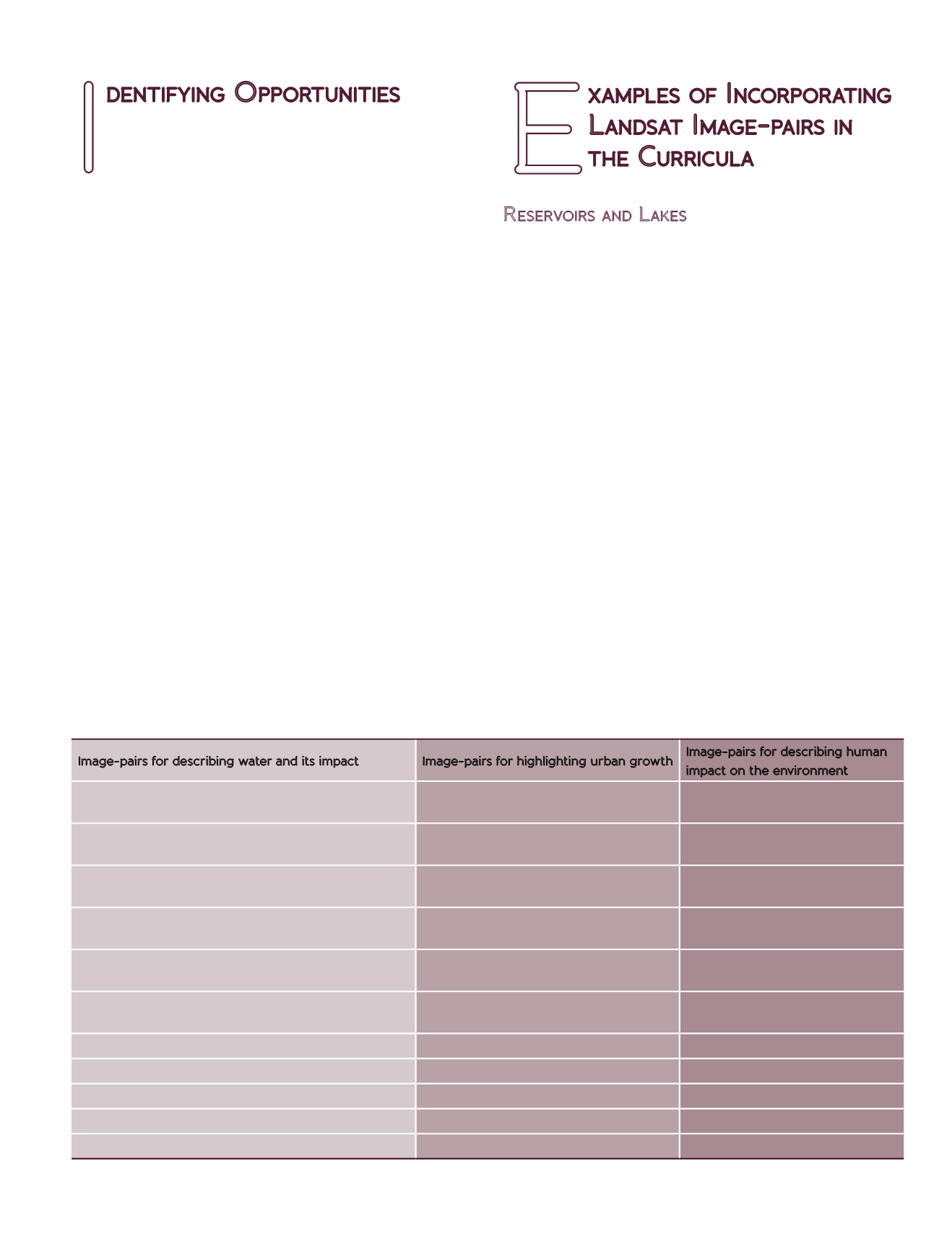
Table 1: Landsat image-pairs introduced in the sixth grade classes and their sources.
Image-pairs for describing water and its impact
Image-pairs for highlighting urban growth
Image-pairs for describing human
impact on the environment
Pathfinder – Seminoe Reservoirs, Wyoming -
WyomingView
Urban growth, Denver – NASA Images of
Change
Gishwati Forest, Rwanda – NASA
Earth Observatory
Drought, North/South Dakota – (2004/ASTER) NASA
Images of Change
Growth in the San Antonio, Texas Region
– USGS Image of the Week
Growth of Mountaintop Mine, West
Virginia – NASA Earth Observatory
Missouri River flooding near Hamburg, Iowa – USGS
Image of the Week
Urban growth, Las Vegas – NASA Images
of Change
Jonah Field, Wyoming –
WyomingView
Flooding, South Dakota –USGS Image of the Week
Aguascalientes, Mexico – Booming
Growth – USGS Image of the Week
Powder River Basin, Wyoming –
WyomingView
Lake Shrinkage, Utah – USGS Image of the Week
Urban growth, Uganda – NASA Images of
Change
Shrimp Farming in Ecuador –
NASA Earth Observatory
Lake Chapala, Mexico - NASA Images of Change
Artificial islands, United Arab Emirates –
NASA Images of Change
Urbanization of the Pearl River
Delta – NASA Earth Observatory
Mar Chiquita – USGS Image of the Week
Flooding, Brazil – USGS Image of the Week
Reservoir Construction, Mali - NASA Images of Change
Tekeze Dam, Ethiopia - NASA Images of Change
Lake Expansion, Ethiopia – USGS Image of the Week


