PHOTOGRAMMETRIC ENGINEERING & REMOTE SENSING
July 2019
471
Ad Index
Dewberry
|
|
476
Geomni, Inc.
|
Geomni.net/psm
|
Cover 4
Question 11—
I also noticed that nearly every drone
software company reports accuracy as a function of
GSD, e.g. heights within three times the GSD. How are
these related, and is GSD really related to accuracy
in any way? I did a project with a GSD of 1 cm, but I
achieved 11 mm RMSE heights and mean of 3 mm.
Answer:
According to the new ASPRS standards, accuracy
should not be associated with imagery GSD or scale because
today’s digital sensors have different configurations and lens
design to enable high-resolution imagery from very high
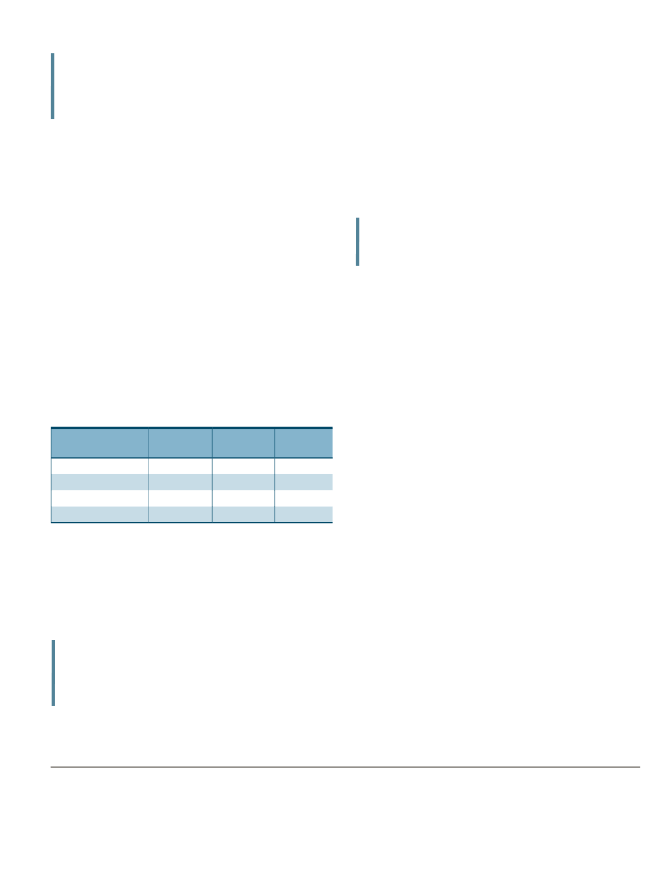
altitudes. Table 3 illustrates how these four metric digital
cameras can be used to acquire imagery with the same
ground resolution of 7.5 cm from drastically varied flying
altitudes, from 2,363 feet to 9,937 feet above ground level
(AGL). One should expect that the accuracy for products
derived from imagery acquired from 9,937 feet AGL should
be inferior to the accuracy of products derived from imagery
acquired from 2,363 feet AGL. That is why we should not
use the GSD as an indicator for product accuracy.
Table 3 Digital Cameras and Flying Altitude Examples
Camera
Focal Length
(mm)
Flying
Altitude (ft)
Resulting
GSD (cm)
ADS80
62.77
2,363
7.5
DMC IIe 230
92.00
4,042
7.5
UltraCAM Falcon Prime
100.00
4,100
7.5
UltraCAM Eagle 210
210.00
9,937
7.5
If the software company is using the GSD as a measurement
of length or dimension, then there is no harm in using the
GSD to quantify products accuracy because all it means is
a quantity. However, if they are using it to associate GSD
as indicator or discriminator of product accuracy, then we
should not condone this practice.
Question 12—
Can you direct me to where I can read
more about rigorous total propagated uncertainty
regarding photogrammetry?
Answer:
As far as I know, there is not a book published on
the topic, but you can find several good published papers on
the topic, among them are the following:
•
C.A. Rodarmel, M.P. Lee, K.L. Brodie, N.J. Spore and
B. Bruder, “Rigorous Error Modeling for sUAS Acquired
Image-Derived Point Clouds,” April 2019 IEEE Transac-
tions on Geoscience and Remote Sensing.
•
H.J. Theiss, “Covariance Propagation from Specific to
Generic Model,” Proceeding the ASPRS 2010 Annual
Conference, San Diego, Calif.
Question 13—
For repeat surveys of the same area, if I
use the software to determine the camera calibration
via self or automatic calibration, is it best to save
it and then use the same calibration for the repeat
flights rather than having the software re-calculate
the camera calibration each time?
Answer:
It is always beneficial to use accurate camera
calibration values in the bundle block adjustment because it
minimizes the amount of parameter optimization. That is also
how we did it when we used large-format metric cameras.
However, because the cameras on board unmanned aircraft
systems (UAS) are consumer-grade non-metric cameras,
you will always need the help of the camera self-calibration
capability of the software for every project, every time you ad-
just a block. Such non-metric cameras do not maintain their
internal calibration geometry, and you will find these internal
camera parameters change from one project to another. It is
always a good practice to use the adjusted camera parame-
ters from previous projects as initial or approximate values
in a new adjustment, as it makes it easier for the software to
refine new values to suit your new project.
**Dr. Abdullah is S Chief Scientist and Senior Associate at Woolpert,
Inc. He is ASPRS fellow and the recipient of the ASPRS Life Time
Achievement Award and the Fairchild Phorogrammetric Award.
The contents of this column reflect the views of the author,
who is responsible for the facts and accuracy of the data pre-
sented herein. The contents do not necessarily reflect the offi-
cial views or policies of the American Society for Photogram-
metry and Remote Sensing and/or Woolpert, Inc.
“The technician selects the mosaic cut lines
path to avoid buildings, trees and other elevated
objects, as well as radiometrically mismatched
areas.”
“There is never a situation in which some values
of statistical terms meet the given thresholds
while other terms fail to meet those thresholds
for a given accuracy class.”
“These CAD files, if they exist, are very helpful in
evaluating the seamline mismatch quality of the
final product, i.e. ortho mosaic.”


