
Conference Schedule
FAQ
Program
-Welcome
-Introduction
-Pre-Program
-Workshops
-Keynote
-Technical Sessions
-Posters
-CEU Hours
-Classified Session
-Technical Tours
-Social Tours
-Registration
-Hotel Floor
Abstracts
Exhibitors
Pecora Award
Business Meetings
Sponsors
Committees
-Steering
-ISPRS
Conference Hotel

Exhibit Prospectus
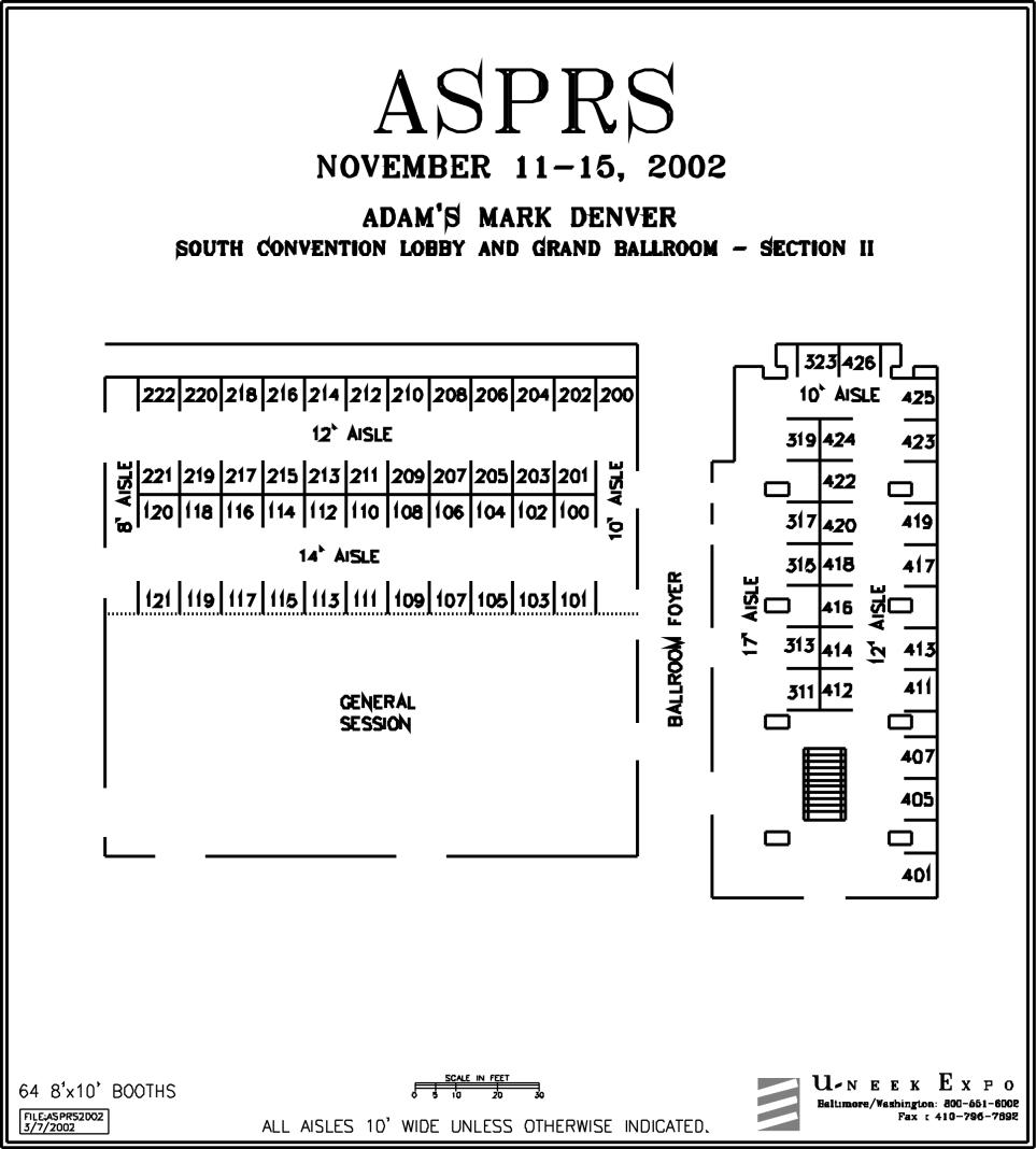
| Exhibit Hours | | Exhibit Floor |
Ampex Data Systems Corp. 219
Applanix Corporation 323
ASPRS 310
ASTERImages and Spectral International 320
BAE SYSTEMS Mission Solutions 216
Boeing Autometric 425
Cardinal Systems, LLC 419
Center for Geospatial Workforce Development 415
Chief Ray Software 205
DigitalGlobe 212/214
Earth Observation Magazine Ballroom Foyer
Earth Satellite Corporation (EarthSat) 105
E. Coyote Enterprises, Inc. 416/418
Emerge 315
ESRI 217
Federal Geographic Data Committee 613
Geospatial Solutions Ballroom Foyer
ImageSat International N.V. 200
KLT ASSOCIATES, INC. 317
Leica Geosystems 311/313
NASA Earth Science Applications 601/603
NASA Earth Science Enterprise/Earth
Observing System 116/118
National Consortium for Remote Sensing 110
National Oceanic and Atmospheric Administration 501/503
National Imagery and Mapping Agency (NIMA) 500/502
PCI Geomatics 426
Pixoneer Geomatics, Inc. 101
Point of Beginning Magazine (POB) Ballroom Foyer
Professional Surveyors Publishing Co., Inc. Ballroom Foyer
Research Systems, Inc., (RSI)11 103
RESOURCE21 319/424
Space Imaging 100/102/104
SPOT Image Corporation 204
The Military Engineer magazine Ballroom Foyer
US Army Engineer Research and Development Center 109
USDA Aerial Photography Field Office 513
U. S. Environmental Protection Agency 111/113
U. S. Environmental Protection Agency 111/113
U. S. Geological Survey 607/609
Vexcel 423
VXServices, LLC 201
Wehrli & Associates Inc. 317
Western Air Maps, Inc. 413
Z/I Imaging Corporation 412/414
Ampex Data Systems Corp. Booth 219
1228 Douglas Ave.
Redwood City, CA 94063-3199
303-697-9499; fax 303-397-9499
don_downing@ampexdata.com www.ampexdata.com
Ampex Data Systems manufactures airborne/ruggedized data acquisition recorders; disk, solid state, tape, and mass storage archival units. New DDRs400 & DSRs400 disk and solid state recorders for airborne collection. Integrated system solutions include ability to ground station archive data acquired with airborne collection units and provide the information with network accessibility. Ampex line of DIS/DST (D2C) 19mm Helical Scan Near Line Robotic Image
Archival Storage Systems.
Applanix Corporation Booth 323
85 Leek Crescent
Richmond Hill, Ontario
CANADA L4B 3B3
905-709-4600; fax 905-709-6027
info@applanix.com; www.applanix.com
Applanix is the world leader in the development, sales and support of aided inertial technology for commercial applications. The company's products are specifically designed for precise measurement of the position and orientation of moving platforms in dynamic environments. As the enabling technology behind airborne direct georeferencing, Applanix's POS AV position and orientation system is the industry standard for geocoding of airborne remote sensor data.
ASPRS Booth 310
5410 Grosvenor Lane
Suite 210
Bethesda, MD 20814
301-493-0290; fax 301-493-0208
asprs@asprs.org www.asprs.org
Visit the ASPRS Bookstore and browse through our variety of publications on Photogrammetry, Remote Sensing, Spatial Data, and GIS Technologies. Take advantage of discounts on select publications during the show. We hope you'll stop by to learn more about upcoming ASPRS conferences, including our 2003 conference in Alaska. ASPRS staff members are available to answer questions and to help you sign up for ASPRS membership. Make sure to pick up a free copy of PE&RS.
ASTERImages and Spectral International Booth 320
P.O. Box 1027
Arvada, CO 80001
303-403-8383; fax 303- 403-8385
pusa@rmi.net www.asterimages.com; www.specmin.com
ASTERImages.com holds a global archive of over 400,000 ASTER 1A scenes and provides data, data bases, custom data conversion, and image processing to the mining industry, and other organizations within the natural resource arena. The primary focus of the company is mineral and petroleum resource exploration. Spectral International is a leading, remote sensing company with worldwide affiliates (Peru, Chile, Mexico, Australia, Canada, South Africa), supplying and using the ASD field portable infrared Reflectance Spectrometers.
BAE SYSTEMS Mission Solutions Booth 216
PO Box 509008, MZ 62-TAL
San Diego, CA 92150-9008
858-592-5721; fax 858-592-5309
pamela.peterson@baesystems.com, www.socetset.com
BAE SYSTEMS Mission Solutions is the forerunner in developing high-quality image exploitation and archiving systems for stereo photogrammetry, photo interpretation, and mapping, charting and geodesy applications. Our Commercial Products organization has offices in Southern California and in the Washington DC area. Please stop by Booth 216 for product demonstrations.
Boeing Autometric Booth 425
7700 Boston Blvd
Springfield, VA 22153
703.923.4000; fax 703.923.4001
grant.crampton@boeing.com; www.autometric.com
Boeing-Autometric, an industry leader in the digital photogrammetric products market, is demonstrating their suite of spatial data production software that incorporates advanced autocorrelation and contouring capabilities. Featured products include SoftPlotter ™, an end-to-end softcopy system, KDMS, a robust vector collection package designed specifically for photogrammetry, and KDSP, which streamlines the production of large-scale vector maps from aerial photography.
Cardinal Systems, LLC Booth 419
175 Lehigh Avenue
Flagler Beach, Florida 32136
386-439-2525; fax 386-439-1553
mike@cardinalsystems.net; www.cardinalsystems.net
With a long and successful history of developing photogrammetric and mapping solutions, Cardinal Systems, LLC continues to provide the most efficient, pragmatic mapping tools available today. We offer VrOne, a powerful photogrammetric vector collection and editing system with image display and DTM; VrTwo, a cost-effective stereo softcopy system integrated seamlessly into VrOne; VrOrtho, which offers orthophoto capability, and VrAirTrig, providing familiar aerial triangulation data collection in the softcopy environment.
Center for Geospatial Workforce Development Booth 415
University of Mississippi
367 Kinard Hall, P.O. Box 1848
University, MS 38677-1848
662-915-3900; fax 662- 915-3901
maten@olemiss.edu; http://geoworkforce.olemiss.edu/
The mission of the Center for Geospatial Workforce Development is to produce a repository of dynamic online coursework in Geospatial Information Technology for enhancement of traditional university learning environment. This coursework will be delivered via internet, CD-ROM, DVD and compressed video, which translates into anywhere, anytime delivery of material in an interactive, learner-centered, multi-modal environment. This wealth of coursework will be utilized for cultivating a highly skilled workforce for future development in geospatial information technologies.
Chief Ray Software Booth 205
Box 1126
Berthoud, CO 80513
970-532-4253; fax 970-532-4557
info@chiefray.com; www.chiefray.com
Chief Ray Software will demonstrate RayTools for Excel, a set of C/C++ functions callable from an Excel spreadsheet for satellite photogrammetry with both terrestrial and celestial observations. Functions include: translations and 3D rotations, including quaternion operations; atmospheric refraction and velocity aberration corrections; ray-ray and ray-surface intersections; support for stellar catalogues, including conversions among mean, apparent, and topocentric places and local horizon coordinates; time conversions between UTC, UT1, TDT, and TDB; and ECF-ECI conversion.
DigitalGlobe Booth 212/214
1900 Pike Road
Longmont, CO 80501
303- 682-3800; fax 303- 682-3848
cherring@digitalglobe.com; www.digitalglobe.com
DigitalGlobe is an imagery and information company located in Longmont, Colorado. DigitalGlobe is establishing a market leadership position by providing the highest resolution satellite imagery products, greatest collection capacity, and the largest image size commercially available.
Earth Observation Magazine Ballroom Foyer
6421 South Clearmont Court
Littleton, CO 80122
303-713-9500; fax 303-713-9944
rolandmangold@worldnet.att.net; www.eomonline.com
Earth Satellite Corporation (EarthSat) Booth 105
6011 Executive Blvd., Suite 400
Rockville, MD 20852-3801
301-231-0660; fax 301-231-5020
rmitchell@earthsat.com; www.earthsat.com
Earth Satellite Corporation (EarthSat) is an international consulting and professional services firm that specializes in the development and application of remote sensing and geographic information technologies (GIS). EarthSat projects focus on mapping, exploration, sustainable development and management of the Earth's resources and the monitoring of the environment. EarthSat is a world leader in the utilization of remote sensing data from aircraft and satellites and is the largest commercial provider of enhanced satellite imagery.
E. Coyote Enterprises, Inc. Booth 416/418
228 Lee Road, P.O. Box 1119
Mineral Wells, TX 76068
940-325-0757; fax 940-325-0941
ecoyote@eastland.net; www.ecoyote.com
The E. Coyote Enterprises booth will feature the UltraScan 5000 from Vexcel Austria, with automatic roll film carrier. This excellent, reasonably priced scanner is enjoying great world-wide acceptance. Also being shown is the IGI mbH (Germany) CCNS4 flight management system and AEROcontrol precise positioning of all airborne sensors.
Emerge Booth 315
800 Federal St.
Suite 200
Andover, MA 01810
800-834-2903; fax 978-557-7300
support@emergeweb.com; www.emergeweb.com
Emerge is both a provider of Digital Sensor Systems that are integrated with GPS and INS and high quality digital orthorectified imagery products that can be used with various land management applications by state, county, municipal and federal governmental agencies, forestry, agriculture, transportation, energy providers and public utilities. The high-resolution aerial imagery from the Emerge DSS can be collected at resolutions of 1, 2, and 3 feet GSD in natural color or color infrared modes.
ESRI Booth 217
380 New York Street
Redlands, CA 92373
909-793-2853; fax 909-307-3072
dmiller@esri.com; www.esri.com
With annual sales of more than $340 million, ESRI remains the world leader in the geographic information system (GIS) software industry. Our business involves the development and support of GIS software for all types of organizations-from the one-person office to multinational corporations to innovative Internet GIS solutions.
Federal Geographic Data Committee Booth 613
590 National Center
Reston, Virginia 20192
703-648-5588; fax 703-648-5755
fgdc@fgdc.gov; www.fgdc.gov
The Federal Geographic Data Committee coordinates the development of the National Spatial Data Infrastructure, which encompasses policies, standards, and procedures for organizations to cooperatively produce and share geographic data. The 17 federal agencies that make up the Federal Geographic Data Committee are developing the National Spatial Data Infrastructure in cooperation with organizations from state, local and tribal governments, the academic community, and the private sector.
Geospatial Solutions Ballroom Foyer
Raritan Plaza III
101 Fieldcrest Avenue
Edison, NJ 08837
732-346-3011; fax 732-225-0211
rfischer@advanstar.com; www.geospatial-online.com
Geospatial Solutions is the most objective and authoritative resource for the community of professionals who develop and deploy GIS and related spatial technologies. The magazine highlights practical applications of GIS, GPS, remote sensing, and mobile technologies in diverse application environments. Its editorial provides solutions-based case studies; timely news about product launches, policy initiatives, market developments, and technical innovations; and management and technology tutorials.
ImageSat International N.V. Booth 200
7 Ayias Phylaxeos Street
P.O. Box 56773
Limassol CY-3025 Cyprus
+357-25-853-700; fax +357-25-853-701
information@imagesatintl.com; www.imagesatintl.com
ImageSat International N.V. is a commercial provider of high-resolution, satellite earth-imagery, collected by EROS A - Earth-Resources Observation Satellite. Acquisition, distribution and Internet access to EROS imagery is made possible through cooperation with ImageSat's global network of affiliates. EROS imagery is ideal for national security and commercial applications, including infrastructure planning, natural-resource management, environmental monitoring, mapping, etc. The Company excels in the speed of order turn-around, affordable pricing, variety of purchase options and customer service.
KLT ASSOCIATES, INC. Booth 317
100 Corporate Place
Peabody, MA 01960
978-536-9100 ; fax 978-536-9110
rob@kltassoc.com; www.kltassoc.com
A complete, fully automatic digital photogrammetric software suite: KLT/ATLAS, for data collection and editing. ATLAS/TIN for contouring, modeling, volumes. ATLAS/DSP for stereo data viewing. ATLAS/ORTHO for fully functional orthophoto production. ATLAS/AT for fully automatic triangulation. Finally, a photogrammetric package that is easy to use and understand. Committed to software and the best service. KLT Associates... Solutions at work.
Leica Geosystems Booth 311/313
2801 Buford Highway, Suite 400
Atlanta, Georgia 30329
404-248-9000; fax 404-248-9400
connie.gilbert@erdas.com www.gis.leica-geosystems.com
Leica Geosystems provides a range of products and systems for capturing, visualizing and modeling spatial data. Leica Geosystems' GIS & Mapping Division offers unparalleled GIS and mapping solutions in the areas of airborne data acquisition and geographic imaging. With sales and service units and committed distributors worldwide, Leica Geosystems is always close to its customers.
NASA Earth Science Applications Booth 601/603
John C. Stennis Space Center
Stennis Space Center, MS 39529
228-688-2998; fax 228-688-3661
bjackson@ssc.nasa.gov
The Earth Science Applications Directorate at Stennis Space Center is part of NASA's Earth Science Enterprise (ESE). Our mission is to extend NASA geospatial science knowledge and technology to the solution of near term socioeconomic problems and enable the growth of a strong national commercial remote sensing industry.
NASA Earth Science Enterprise/Earth Observing System Booth 116/118
NASA Goddard Space Flight Center
Greenbelt, MD 20771
301-614-5560; fax 301- 614-6530
winnie.humberson@gsfc.nasa.gov; www.eos.nasa.gov
Since its creation in 1958, NASA has been studying the Earth and its changing environment by observing the atmosphere, oceans, land, ice and snow, and their influence on climate and weather. In 1991, NASA launched Earth Science Enterprise Program to study the Earth. Using satellites and information from ground-based sources, and working with nations of the world, we hope to improve our knowledge of the Earth system for the benefit of future generations.
National Consortium for Remote Sensing Booth 110
NCRST - Hazards, Safety and Disaster Assessment. Dr. Richard Watson, Earth Data Analysis Center, University of New Mexico, rwatson@edac.unm.edu
NCRST - Environment Assessment. Dr. Roger King, Mississippi State University, rking@ece.msstate.edu
NCRST - Flows. Dr. Joel Morrison, The Ohio University, morrison@cfm.ohio-state.edu
NCRST - Infrastructure. Dr. Val Noronha, University of California Santa Barbara, noronha@ncgia.ucsb.edu
http://www.ncrst.org/
The National Consortia on Remote Sensing in Transportation (NCRST) features results of USDOT-sponsored research in four focus areas: Environment, Infrastructure, Traffic Flow and Hazards, by university research consortia in cooperation with private sector Technology Application Partners. Projects address issues in transportation corridor
alignment, critical infrastructure protection and intelligent transportation systems, among other areas.
National Oceanic and Atmospheric Administration Booth 501/503
National Environmental Satellite, Data, and Information Service
NOAA/NESDIS
SSMC1, 8th Floor, 1335 East-West Highway
Silver Spring, Maryland 20910
301-713-3578; fax 301-713-1249
www.nesdis.noaa.gov
NOAA NESDIS manages the Nation's civil, operational, environmental satellites and operates the NOAA National Data Centers. Our mission is to provide and ensure timely access to global environmental data from satellites and other sources, and to provide information services including earth system monitoring and performing official assessments of the environment, for protection, and enhancement of the Nation's economy, security, environment, and quality of life.
National Imagery and Mapping Agency (NIMA) Booth 500/502
4600 Sangamore Road, Mail Stop: D-143
Bethesda, MD 20816-5003
301- 227-1403; fax 301- 227-0117
harperm@nima.mil; www.nima.mil
The National Imagery and Mapping Agency (NIMA) was established October 1, 1996 to provide timely and accurate imagery, imagery intelligence and geospatial information in support of the nation's military forces and national policy makers and civil users.
PCI Geomatics Booth 426
50 West Wilmot St., #200
Richmond Hill, ON
Canada L4B 1M5
905- 764-0614; fax 905- 764-9604
info@pcigeomatics.com; www.pcigeomatics.com
PCI Geomatics is a world leading developer of geomatics software and solutions designed to maximize both the productivity and work efficiency for all customers in the remote sensing, digital photogrammetry, spatial analysis, and cartographic fields. In particular, PCI Geomatics software offers superior raster and vector processing capabilities required to meet the growing demands being placed on today's geomatics professionals. PCI Geomatics has been in the geospatial software business since 1982.
Pixoneer Geomatics, Inc. Booth 101
777 Leesburg Pike, Suite 7LS
Falls Church, VA 22043
703-852-2162 or 866-PIXONEER; fax 703-852-2170
info@pixoneer.com; www.pixoneer.com
Pixoneer Geomatics is a premier provider of image processing software and services for education and research institutions, government agencies, military, and commercial entities. Pixoneer's image processing software earth is fully functional and offers easy to use integrated robust tools for preprocessing, visualization, manipulation, and analysis of spatial data. Earth's elegant interface allows user with different levels of expertise to perform sophisticated processes by pointing and clicking to quickly derive accurate and reliable information from imagery.
Point of Beginning Magazine (POB) Ballroom Foyer
755 Big Beaver, Suite 1000
Troy, MI 48084
248-362-3600; fax 248-362-5103
www.pobonline.com
Professional Surveyors Publishing Co., Inc. Ballroom Foyer
100 Tuscanny Drive, Suite B-1
Frederick, MD 21702
301- 682-6101; fax 301- 682-6105
allen@profsurv.com; www.profsurv.com
Professional Surveyor Magazine (www.profsurv.com), is the premier U.S. resource for surveying, mapping, engineering, GPS, and GIS professionals. Each month, in-house editor and surveyor, Marc Cheves, and our team of nationally-recognized contributing writers create timely articles covering cutting-edge technology, hardware and software reviews, hands-on solutions, business management, book reviews, factory tours, product recaps from trade shows, and more. Professional Surveyor Magazine also publishes the GIS Monitor (www.gismonitor.com), a popular weekly e-mail newsletter edited by Adena Schutzberg.
Research Systems, Inc., (RSI) Booth 103
4990 Pearl East Circle
Boulder, CO 80301
303-786-9900; fax 303-786-9909
info@RSInc.com; www.RSInc.com
Research Systems, Inc. (RSI) is dedicated to creating the best analysis, visualization and application development tools to help scientists and engineers minimize programming and gain deeper insight. RSI's product line includes: IDL, the complete, integrated software environment for data analysis, visualization and application development; ION, which brings the power of IDL to the internet; ENVI, an image processing application written in IDL, allowing access and analysis of remotely sensed data; and EON, ENVI on the Net.
RESOURCE21 Booth 319/424
4601 DTC Blvd., Suite 875
Denver, CO 80237-2575
720-274-4000; fax 720-214-0474
keggen@resource21.com; www.resource21.com
RESOURCE21, L.L.C. is a satellite data provider and value-added reseller serving the needs of both commercial and government customers for basic imagery, thematic maps and thematic reports, and value-added products In particular, RESOURCE21 is focused on the information needs of customers worldwide who are involved in production agriculture and related food industries, Earth Science, commodities trading and logistics, broad-area change detection, crop insurance, U.S. National Security, U.S. Civil & Science and municipal planning.
Space Imaging Booth 100/102/104
12076 Grant Street
Thornton, Colorado 80241
303-254-2000; fax 303-254-2215
sneufeld@spaceimaging.com, www.spaceimaging.com
Space Imaging is a leading supplier of visual information products and services derived from space imagery and aerial photography. The company launched the world's first and only one-meter resolution, commercial Earth imaging satellite, IKONOS™, on Sept. 24, 1999. Other products are produced from the Indian Remote Sensing satellites, the U.S. Landsat satellites and Canada's RADARSAT. Space Imaging also delivers aerial-derived imagery products collected by its own Digital Airborne Imaging System (DAIS-1™).
SPOT Image Corporation Booth 204
14595 Avion Parkway, Suite 500
Chantilly, Virginia, 20151
703-715-3102; fax 703-715-3120
black@spot.com
SPOT Image Corporation will show its newest products and services from the SPOT 5 satellite, launched in May 2002. In addition, they will discuss their innovative Channel Partner business model, and introduce the North American Channel Partners-Digital Globe, RESOURCE 21 and IUNCTUS Geomatics. SPOT continues to stretch the standards for products and commercial concepts within the U.S. and around the globe.
The Military Engineer Magazine Ballroom Foyer
607 Prince St.
Alexandria, VA 22314-3117
703-549-3800, fax 703-548-6153
jnichols@same.org; www.same.org
Published since 1920, The Military Engineer magazine is the flagship publication of the Society of American Military Engineers. It is a bimonthly, 64- to 80-page, full-color magazine, containing feature articles and news items, written by professionals in the field, about many architecture, engineering and construction topics in government and industry. The publication helps to promote exchanges among industry and government officials about engineering issues of consequence to national readiness, security and protection.
US Army Engineer Research and Development Center Booth 109
7701 Telegraph Road
Alexandria, VA 22315
703-428-6600; fax 703-428-8154
adodge@tec.army.mil; www.erdc.usace.army.mil
The Engineer Research and Development Center is the premier research and development facility for the U.S. Army Corps of Engineers. It consists of seven laboratories at four geographical sites, with over 2,000 employees, $1.2 billion in facilities, and an annual research program exceeding $550 million. It conducts research in both military and civil works mission areas for the Department of Defense and the nation.
USDA Aerial Photography Field Office Booth 513
2222 West 2300 South
Salt Lake City, Utah 84119
801-975-3500; fax 801-975-3529
kwilliams@apfo.usda.gov; www.apfo.usda.gov
The Farm Service Agency's Aerial Photography Field Office (APFO) is the official aerial film and digital image library for the USDA. Holdings include National Agricultural Imagery Program (NAIP) film and digital imagery, compressed county mosaics of digital ortho photography, and historical aerial photography dating back to the mid-1950's. The library totals over 10 million film negatives and digital images. Reproductions of data held in the APFO library are available at a nominal cost.
U. S. Environmental Protection Agency Booth 111/113
Office of Environmental Information (OEI)
Washington, DC
OEI will be displaying and promoting the theme Assessing Urban Growth and Land Cover Trends in Metropolitan Areas.
U. S. Environmental Protection Agency Booth 111/113
Office of Research and Development (ORD)
Washington, DC
ORD will be displaying and promoting the theme Remote Sensing and GIS Research Projects Applied to Landscape Sciences.
U. S. Geological Survey Booth 607/609
Rocky Mountain Mapping Center
Denver, Colorado
1 888-ASK-USGS
ask@usgs.gov; www.usgs.gov
Scientists from USGS, will discuss obtaining and using different types of remotely sensed and other spatial data available from USGS. These data include Landsat, TERRA, MODIS, ASTER, EO-1, SRTM, National Land Cover Data, National Elevation Data, Digital Orthophotography, Digital Raster Graphics, National Hydrography Dataset, and Digital Elevation Models. Information sheets, examples, ordering information, and demonstrations will be available. Research on urban growth, natural hazards, water quality, biodiversity, and Internet Map Server development will be featured.
Vexcel Booth 423
4909 Nautilus Court, North
Boulder, Colorado 80301
303-444-0094; fax 303-583-0246
info@vexcel.com
VXServices, LLC Booth 201
1230 Hunter Court
Longmont, Colorado 80501
303-651-6519; fax 303-651-7693
bloupee@vxservices.com; www.vxservices.com
The primary mission of VXServices, LLC is to provide support and service to the large number of Vexcel scanners deployed around the world. The growing demand for new scanners and ongoing maintenance support confirms the strong position the VX4000HT has earned in the high resolution, high accuracy scanning market.
Wehrli & Associates Inc. Booth 317
7 Upland Drive
Valhalla, New York 10595
914-948-7941 ; fax 203-761-9055
info@wehrliassoc.com; www.wehrliassoc.com
Wehrli and Associates will be demonstrating the latest RM-4 TableTop photoscanner. They also offer the RM-3 AutoScanner and RM-2 Cut Sheet photoscanners to the photogrammetric market. The company goal is to provide leading edge photogrammetric systems of the highest quality at the lowest cost; thereby offering their customers the ability to earn a fair and quick return on their investment.
Western Air Maps, Inc. Booth 413
9401 Reeds Road
Overland Park, KS 66207
800-643-5177; fax 913-652-9933
western@westernair.com; www.westernair.com
Western Air Maps, Inc. (WAM), a small business, established in 1960 is a full service aerial photography, surveying, and photogrammetric firm. WAM provides superior services to both public and private sector clients including B/W, color and color infrared aerial photography; remote sensing, airborne GPS, aerotriangulation, stereo compilation, digital orthophotography, and GIS. WAM's focus is providing quality professional photogrammetric services and outstanding customer service to our clients by employing a highly qualified staff, guided by professional management.
Z/I Imaging Corporation Booth 412/414
301 Cochran Road, Suite 9
Huntsville, AL 35824
256-730-1590 ; fax 256-730-6708
info@ziimaging.com; www.ziimaging.com
Z/I Imaging is the world's largest company dedicated to the development and support of Earth Imaging tools. Z/I Imaging's solutions include aerial cameras, photogrammetric scanners and workstations, and image management, processing, and distribution software. The imaging software includes enterprise solutions that combine the power of a client/server image management and distribution system with a high performance imaging engine to quickly provide information needed. Z/I Imaging is dedicated to providing world-class consulting, training, and support services
Exhibit Hours
Monday November 11
Decorator Move-in
6:00 am to 7:00 pm
Exhibitor Move-in
7:00 pm to midnight
Tuesday, November 12
Exhibitor Move-in
7:00 am to 5:00 pm
Opening Reception
5:30 pm to 7:00 pm
Wednesday, November 13
10:00 am to 6:30 pm
Thursday, November 14
9:45 am to 2:30 pm
Tear Down
2:30 pm to 10:00 pm
Lunch and Breaks will be served in the exhibit hall daily.
Exhibit Hall Location - The Conference Exhibition Hall will be located in the Adam's Mark Hotel; see Exhibit Hall floor plan for more details.
Show Decorator & Drayage Firm
U-Neek Expo has been named the official decorating service contractor. All questions or correspondence concerning the shipment of materials, decorating, booth furnishing, electrical or phone service, etc. should be directed to U-Neek at:
-
7045 Troy Hill Drive, Suite 300 Elkridge, MD 21075
410-796-7601 w 410-796-7648 (fax) service@uneekexpo.com
Go to Top
Exhibit Hall Floor Plan
 Copyright © 2001 American Society for Photogrammetry & Remote Sensing
5410 Grosvenor Lane, Suite 210, Bethesda, Maryland 20814-2160
URL: http://www.asprs.org/
Maintainer: Pecora Committee
Last Update: September 15, 2002