PHOTOGRAMMETRIC ENGINEERING & REMOTE SENSING
May 2019
341
by
Clifford J. Mugnier, CP, CMS, FASPRS
T
he Bolivian highlands were the location of
the advanced Tiahuanaco culture, circa the
7
th
to 11
th
centuries. The Aymara Indians
followed and were conquered in the 15
th
century
by the Inca Indians. The Incas were subsequently
conquered in the 1530s by Hernando Pizarro, the
half-brother of Francisco Pizarro who conquered
Peru. Bolivia achieved independence from Spain
by proclamation of Simón Bolívar on August 6,
1825 when General Antonio José de Sucre invaded
Characas. A map of Bolivia that was printed on a
1928 Bolivian postage stamp precipitated a war
with Paraguay in the 1930s over the Gran Chaco
region! After learning about that postage stamp, I
began collecting “map stamps” of the world.
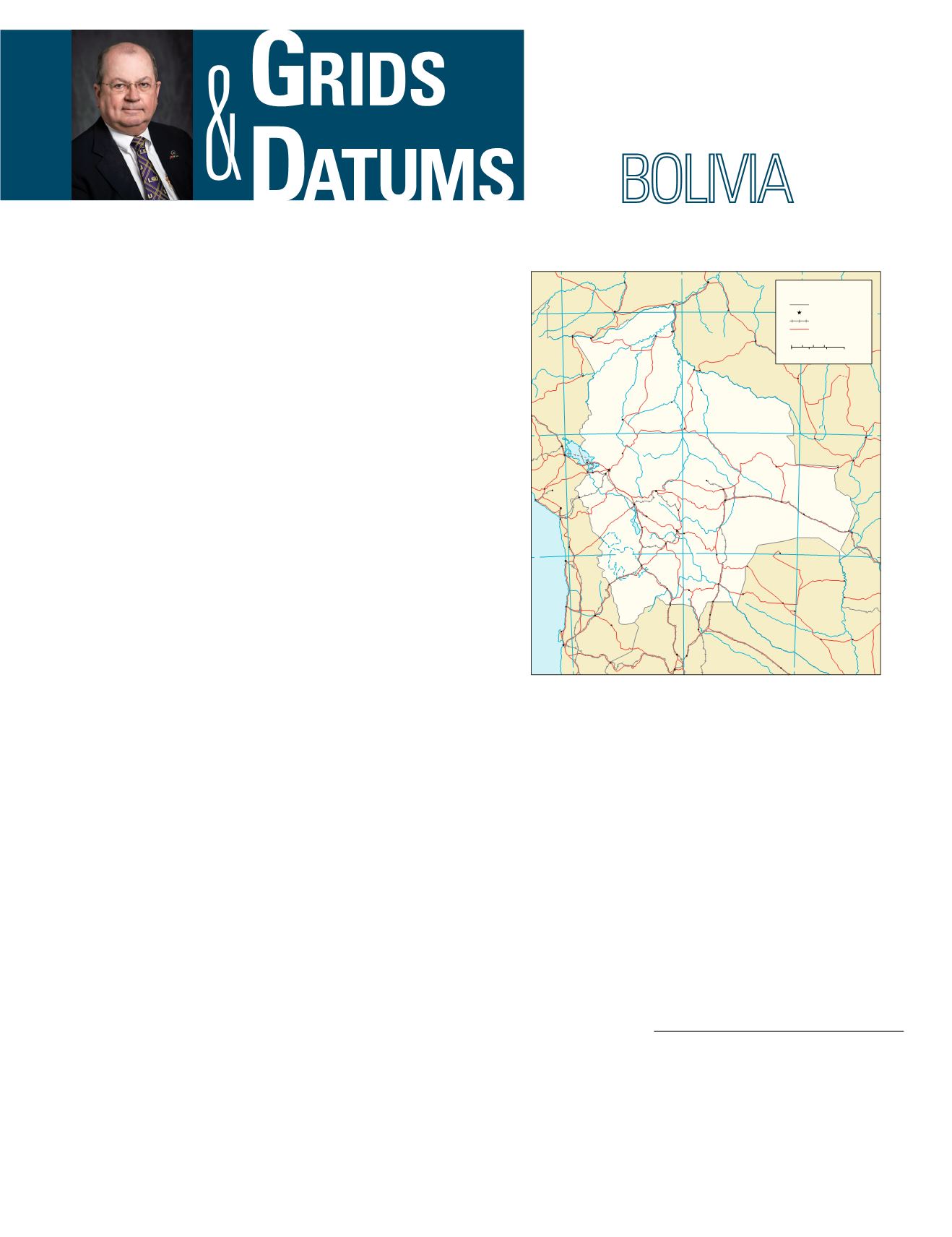
The eastern part of Bolivia has low, hot, fertile land wa-
tered by many rivers. In the central part of the eastern slope
of the Andes, there is a high plateau region that includes part
of the Gran Chaco. Lake Titicaca is in the western part of
the central ranges and the highest peaks which include Cer-
ro Illimani at 6,882 m. The lowest point in Bolivia is the Rio
Paraguay at 90 m.
Bolivia has had a cartographical history quite unlike that
of any of the other west coast republics of South America. Not
only did the period of instrumental surveys begin much later
in the Republic of Bolivia, but until 1921, when the Amer-
ican Geographical Society began the compilation of the La
Paz 1:1,000,000 sheet, there had never been a general map of
the country that could be described as an exhaustive compi-
lation. J. B. Pentland, an English explorer and cartographer,
opened the era of exploration and discovery in Bolivia with
his work on the Altiplano and in the Eastern Cordillera of
the Andes that he carried out in 1827 and 1828. His surveys
and later work in 1837-1838 were published as charts by the
British Admiralty in 1830 and 1839, respectively. The most
important part of Pentland’s work was his determinations
THE REPUBLIC OF
The Grids & Datums column has completed an exploration of
every country on the Earth. For those who did not get to enjoy this
world tour the first time,
PE&RS
is reprinting prior articles from
the column. This month’s article on The Republic of Bolivia was
originally printed in 2001 but contains updates to their coordinate
system since then.
of altitudes and astronomical positions, the latter of which
were used for many years as the basis for survey work in and
for all compiled maps of the areas he covered. His determi-
nations of altitudes in the Cordillera Real not only attracted
the attention of other explorers to this hitherto little-known
section of the Andes, but also gave rise to much controversy.
That was because they indicated that the highest crests of the
Bolivian section of the Andes were among the highest, if not
actually the highest, in the whole Cordillera. It was believed,
up to that time, that the snow-capped volcanoes of Ecuador
held that distinction. Meanwhile in 1830, Alcide d’Orbigny, a
French anthropologist and geologist, had begun the explora-
tions that resulted in his
Carte Générale de la République de
Bolivia
at a scale of approximately 1:1,575,000, published in
1835-1847 in his
Voyage dans l’Amérique Méridionale
.
Thanks to Sequoia Read of the Defence Geographic and
65
70
60
65
60
70
10
15
20
10
15
20
PERU
ARGENTINA
CHILE
PARAGUAY
BRAZIL
BRAZIL
Lago
Titicaca
Lago
Poopó
Salarde
Uyuni
SOUTH
PACIFIC
OCEAN
R
i
o
J
a
m
a
r
i
R
i
o
G
u
a
p
o
r
é
R
í
o
I
t
é
n
e
z
R
í
o
T
e
u
c
o
R
í
o
C
h
a
p
a
r
é
R
í
o
D
e
s
a
g
u
a
d
e
r
o
R
í
o
M
a
d
r
e
d
e
D
i
o
s
R
í
o
L
o
a
R
í
o
B
e
n
i
R
i
o
I
a
c
o
R
í
o
P
i
l
c
o
m
a
y
o
R
í
o
S
a
n
P
a
b
l
o
R
í
o
P
i
l
c
o
m
a
y
o
Rí
o
V
er
d
e
R
i
o
P
a
r
a
g
u
a
i
R
í
o
Y
a
c
u
m
a
R
í
o
G
r
a
n
d
e
R
i
o
P
u
r
u
s
R
i
o
A
c
r
e
R
i
o
J
a
c
i
p
a
r
a
n
á
R
i
o
J
i
-
P
a
r
a
n
á
R
i
o
T
a
q
u
a
r
i
R
í
o
P
a
r
a
g
u
a
y
R
i
o
M
a
d
e
i
r
a
P
a
n
-
A
m
e
r
i
c
a
n
H
i
g
h
w
a
y
P
a
n
-
A
m
e
r
i
c
a
n
H
i
g
h
w
a
y
f
e
r
r
y
R
í
o
G
r
a
n
d
e
R
í
o
S
é
c
u
r
e
R
í
o
M
a
m
o
r
é
R
i
o
J
u
r
u
r
e
n
a
R
í
o
I
t
o
n
a
m
a
s
(saltpan)
u/c
Oruro
LaPaz
Cochabamba
SantaCruz
Sucre
Potosí
Tarija
Trinidad
Cobija
Puno
Juliaca
Iñapari
Riberalta
Puerto
Maldonado
RioBranco
Bôca doAcre
Abunã
Pôrto
Velho
Ariquemes
Presidente
Médici
Assis
Brasil
Brasiléia
Toquepala
Ilo
Moquegua
Tacna
Charaña
Guaqui
Desaguadero
Copacabana
Viacha
Caranavi
SantaAna
deYacuma
Magdalena
Rurrenabaque
Arica
Iquique
Tocopilla
Mejillones
Socompa
Salta
SanRamón
de la
NuevaOrán
Villazón
LaQuiaca
Tupiza
Yacuiba
Villamontes
SanSalvador
de Jujuy
Calama
Antofagasta
Ollagüe
Uyuni
Tarabuco
Montero
San Ignacio
deVelasco
Corumbá
Filadelfia
Capitán
Pablo Lagerenza
General
EugenioGaray
Pozo
Colorado
Concepción
Pôrto
Murtinho
Puerto
Suárez
San José
deChiquitos
SanMatías
Cáceres
Pontes e
Lacerda
Barra do
Bugres
Aiquile
Uncia
Guayaramerín
Guajará-Mirim
PuertoUstarez CostaMarques
Mariscal
Estigarribia
Fortín
Infante
Rivarola
Las Lomitas
Tartagal
SanPedro
Challapata
Zapiga
SanPedro
deAtacama
FuerteOlimpo
Camiri
Roboré
Yapacani
Vilhena
TransverseMercatorProjection,CM64W
0 50 100 150Kilometers
0
50
100 150Miles
Bolivia
International boundary
National capital
Railroad
Road
Base 803201AI (G00397)4-06
Photogrammetric Engineering & Remote Sensing
Vol. 85, No. 5, May 2019, pp. 341–342.
0099-1112/18/341–342
© 2019 American Society for Photogrammetry
and Remote Sensing
doi: 10.14358/PERS.85.5.341


