10
January 2014
PHOTOGRAMMETRIC ENGINEERING & REMOTE SENSING
placements in the north-south direc-
tion). The descending and ascending
PSInSAR image stacks are processed
separately, and then the resulting
PS clouds are merged using data fu-
sion procedures (e.g., Gernhard
et al
.,
2012). Finally, PSInSAR line-of-sight
displacements from both descending
and ascending tracks are decomposed
to measurements in the east-west and
vertical directions. The resulting infor-
mation can provide additional insights
into the nature and cause(s) of the ob-
served deformation.
Multi-aperture InSAR –
Monitoring Along-track
Deformation
It is nearly impossible to retrieve the
along-track or north-south component
of ground displacement from multi-
track InSAR or PSInSAR images. This
is a consequence of the polar orbits of
current SAR satellites, which travel
nearly from south to north along as-
cending tracks or from north to south
along descending tracks. Multi-aper-
ture InSAR (MAI) exploits the phase
difference between forward- and back-
ward-looking interferograms produced
from sub-aperture SAR images to map
displacements in the along-track direc-
tion (Becher and Zebker, 2006; Jung
et al
., 2009). For MAI analysis, each
SAR image is divided into two images,
one forward-looking and one back-
ward-looking, and two corresponding
interferograms are produced. MAI mea-
surements are sensitive to north-south
displacement and, when combined with
conventional InSAR measurements,
can be used to map surface displace-
ment in 3-D. MAI has been used to
retrieve ground deformation associated
with large earthquakes, volcanic erup-
tions, and glacier movement (e.g., Jung
et al
., 2011). MAI applications currently
are limited to large or abrupt ground
displacements due to the technique’s
greater susceptibility
to decorrelation
relative to conventional InSAR.
SqueeSAR — Integration of
Distributed Scatterer and
Persistent Scatterer Techniques
To improve the spatial coverage of
deformation estimates in non-urban
areas, Ferretti and others (2011)
proposed to jointly analyze persistent
scatterers (PS) and distributed
scatterers (DS), which are defined
as statistically homogenous pixels.
In contrast to PSs that typically are
associated with man-made structures,
boulders, and outcrops, DSs can be
debris areas, non-cultivated land with
short vegetation, desert areas, or
other types of homogeneous surfaces.
A spatially adaptive de-speckle
filter can be applied to identity DSs.
Because
phase values
of PSs are
generally
deterministic
and the
phases of
DSs are
stochastic,
phase
triangulation
can then
be applied
to estimate
optimum
phase values
for DSs
based on
candidate
pixels’
coherence properties and statistical
characteristics. As the final step,
DSs and PSs can be combined and
processed using standard PSInSAR
techniques to produce time-series
deformation measurements at
a spatial density higher than
traditional PSInSAR measurements
(Ferretti and others, 2011).
SAR Tomography — Looking into
3-D Structure of Scatterers
Another exciting line of investiga-
tion involving the fusion of multiple
SAR images is SAR tomography (e.g.,
Reigber and Moreira, 2000). A single
SAR image maps 3-D characteristics
of ground resolution elements into
the 2-D SAR imaging plane (i.e., the
slant range and azimuth directions).
For vegetated terrain, the backscat-
tering return at a SAR image pixel
represents the projection of 3-D dis-
tributed targets within each ground
resolution element. Repeat-pass SAR
images can be combined interferomet-
rically to generate an InSAR image,
which represents the average height
of targets within each pixel. For vege-
tated terrain, the InSAR height corre-
sponds to the effective, average height
of vegetation within the pixel, so the
3-D structure of scatterers in the pixel
is lost. With the Pol-InSAR technique,
various targets within each pixel can
be separated if their polarimetric back-
scattering signatures are sufficiently
different. However, this is not possible
when the polarimetric signatures of
targets are similar. SAR tomography,
on the other hand, utilizes the varia-
tion of spatial baselines from multiple
SAR images to construct a second
synthetic aperture in the direction
perpendicular to both the line-of-sight
direction and the azimuth direction.
In this way, the 3-D distribution of
dominant scatters in a resolution ele-
ment can be resolved (e.g., Reigber and
Moreira, 2000). SAR tomography has
the potential to dramatically improve
estimates of vegetation structure, and
even to alleviate geometric distortion
(e.g., layover effect) that plagues tradi-
tional SAR images of steep terrain.
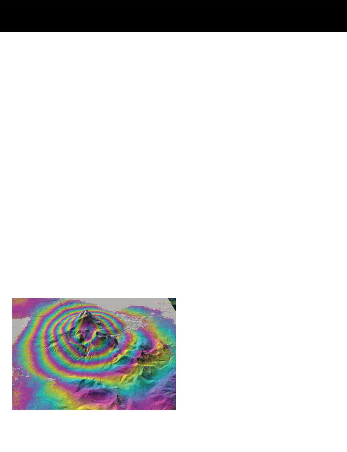
InSAR image showing inflation of Mt. Peulik volcano (Alaska) during
1996-1998.


