densely clustered natural forests. It works best when crowns
have clear boundaries, are approximately symmetrical, similar
in size, and do not overlap each other (Bunting and Lucas,
2006). Similarly, the topographic concept of a watershed can
also be applied to the contour detection and image segmenta-
tion according to Beucher and Lantuejoul (1979). And, the
topographic concept of a watershed can also be extended to
delineate individual tree crowns. It is another more commonly
applied method for determining tree crowns (Edson and Wing,
2011), and called Inverse Watershed Segmentation (
IWS
).
The
IWS
method converts the elevation of the surface
model to form the equivalent of individual hydrologic drain-
age basins (Edson and Wing, 2011; Swamer and Houser, 2012;
Wannasiri
et al
., 2013). These individual drainage basins
(canopy basins) represent tree crowns. As the algorithm relies
on an inverted surface model, the accuracy and the resolution
of the digital surface model is important. For example, Edson
and Wing (2011) found that the canopy height model with 1
m resolution of a conifer forest decreased the commission er-
rors caused by upward facing branches of the same tree when
tree tops were 1 m apart from each other.
The tree modeling and image template method constructs
geometric models of trees (templates) and matches them to
images (Korpela
et al
., 2007; Wolf and Heipke, 2007). During
this process, shape parameters such as crown diameter, tree
height, and convexity are investigated and often modeled
by means of a generalized ellipsoid. Therefore, the model of
the tree which is similar to the visible trees in the remotely
sensed image in terms of viewing and illumination is created
as a three-dimensional projection of a tree crown (Larsen
et al.
, 2011; Larsen and Rudemo, 1998). Hence, the optimal
shape and the placement of bounding ellipse in an image vary
with image acquisition geometry (Larsen and Rudemo, 1998).
Although many algorithms have been investigated for
individual tree crown delineation, it is clear that no single
algorithm is universally successful in delineating the crowns
of all different vegetation types (Kaartinen
et al
., 2012; Larsen
et al
., 2011; Li
et al
., 2008). Most methods are based on image
intensities, elevation, and homogeneity of vegetation with
reasonable height variations. Further, these methods are more
successful with plantation forests having regular distances
between trees rather than naturally grown forests (Bunting and
Lucas, 2006). Unfortunately, such variations are rare in man-
grove forests. When considering forest types, although most al-
ready established methods have been successful in coniferous
forests, often they do not work well in deciduous and mixed
species forests (Jing
et al.
, 2012). Deciduous tree crowns are
also relatively flat (Jing
et al
., 2012) and thus resemble man-
grove crowns. Therefore, the methods that have already been
developed for identifying individual trees of terrestrial vegeta-
tion may not be suitable for mangrove environments.
This study evaluated the potential of using high spatial
resolution optical remote sensing data and an object based
image analysis (
GEOBIA
) approach for outlining mangrove tree
crowns by: (a) applying
GEOBIA
to WorldView-2 (
WV
2) data; (b)
applying
GEOBIA
to the combined
WV
2 and a high resolution
digital surface model (
DSM
) derived from aerial photography;
and (c) applying the
ISW
method to the
DSM
.
Data and Methods
Study Area, Remote Sensing Data, and Preprocessing
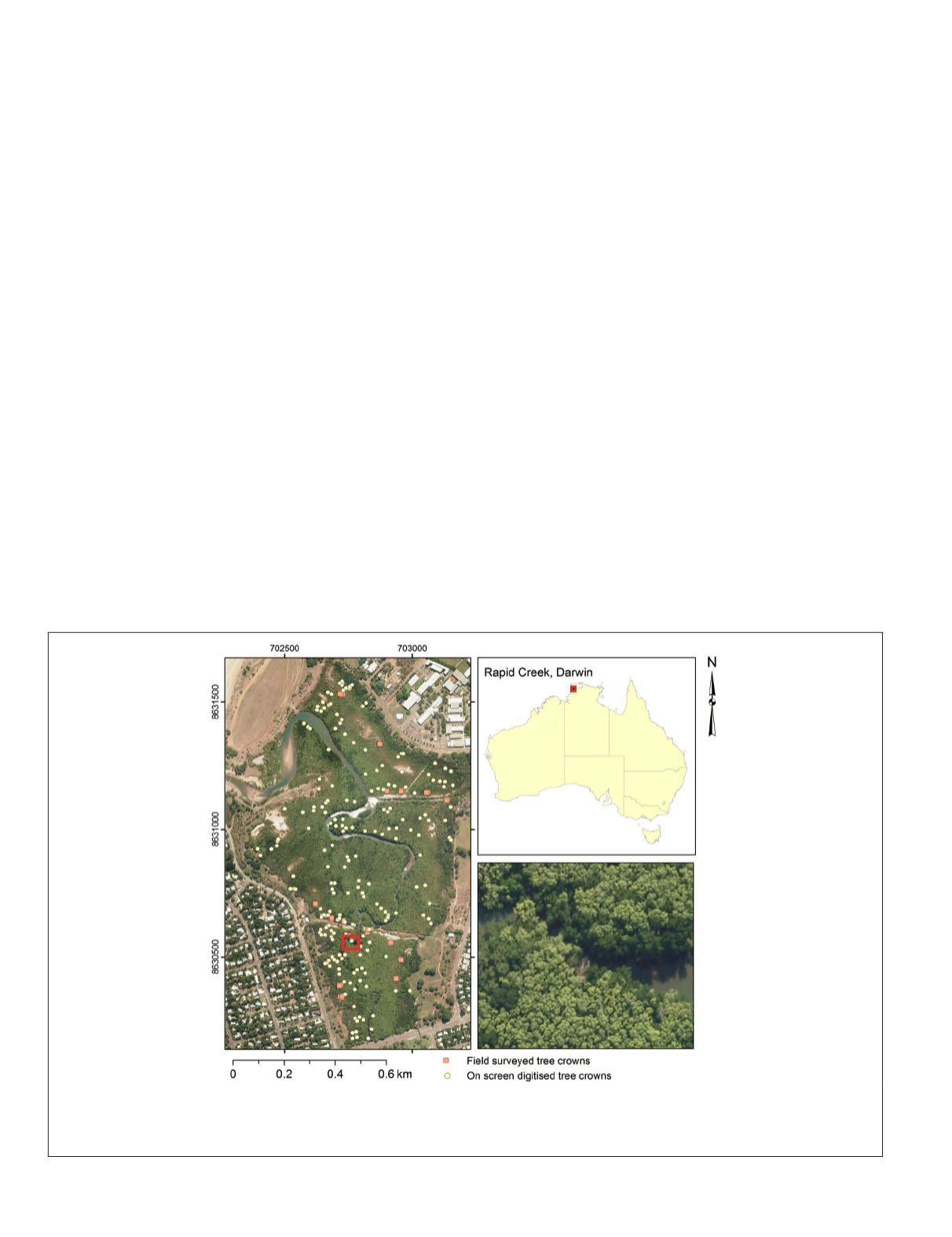
This study focused on a small mangrove forest situated in
the Rapid Creek coastal system near Darwin, Australia (Plate
1). The Rapid Creek mangrove forest covers approximately
60 hectares in extent, and is centered at E/12°22' S/130°51'.
The mangrove forest naturally regenerated after a proposed
housing project was abandoned shortly after a clearing in
1969 (Ferwerda
et al
., 2007). The area is comprised of diverse,
Plate 1. The study area is located in Rapid Creek in Darwin, Northern Territory, Australia. The map shows the validation dataset includ-
ing both field surveyed and on-screen digitized (three-dimensionally) trees. Inset shows the appearance of mangrove tree crowns on the
aerial photograph; Coordinate system: Universal Transverse Mercator Zone 52 L, WGS84; Aerial photographs © Northern Territory Govern-
ment (
ntg
), Australia, Copyright 2012
ntg
.
472
June 2015
PHOTOGRAMMETRIC ENGINEERING & REMOTE SENSING


