2003; Bouziani
et al
., 2010; Koc-San and Turker, 2012; Karant-
zalos, 2015). In particular, Bailloeul
et al
. (2003) combined the
information from an existing
GIS
database (spatial and geomet-
ric information), a
DSM
, and a satellite image. Along with some
rules, they proposed a model to address the building detection
task. Moreover, Koc-San and Turker (2012) integrated the in-
formation extracted from an Ikonos stereo pair
DSM
along with
the classification result from a
SVM
classifier. By blending the
extracted information with the vector information from exist-
ing databases, building changes were identified.
Since 3D information is often not available or of insuf-
ficient spatial resolution, research efforts towards the devel-
opment of operational, cost-effective change detection and
map updating tools have been based on exploiting satellite
multispectral data and existing maps. Bouziani
et al
. (2010)
proposed an approach to combine the vector layers from
an existing geodatabase with the spectral information from
satellite imagery. A knowledge base describing objects shape,
spectral, and topological attributes was developed and then
appropriate change detection rules were implemented in
order to associate object-based and prior information.
In a similar way for this paper, we have designed, devel-
oped, and evaluated an object-based methodology for build-
ing change detection based on very high resolution multispec-
tral satellite data and existing geoinformation (e.g., cadastral
database, urban maps, etc). To address the significant spectral
variability of the different building rooftop materials, we
employ an unsupervised classification step to group the dif-
ferent spectra. A number of validation criteria were applied
to facilitate the automated selection of the clusters. Following
this, a learning procedure based on the available maps and
the calculated object-based building features was applied. A
rule-based classification procedure is finally detecting all the
new buildings in the study area. In summary, based on cost-
effective datasets, the developed framework exploits the avail-
able vector data, adequately trains a classifier, and introduces
an effective knowledge-based procedure for the detection of
building changes over urban regions.
Dataset and Study Area
In order to validate the developed methodology, urban regions
known to have undergone some change over a ten-year period
were targeted in this study. In particular, the study area covers
a part of Thessaloniki City in northern Greece, including the
suburbs of Pylaia and Kalamaria. In these areas, a great deal of
building construction activity is known to have occurred be-
tween the years 2000 and 2010. The dataset includes a vector
layer in a geospatial database indicating the footprints of the
existing buildings, the road network in 2003, and a very high
resolution satellite image, i.e., the four bands of a pan-sharp-
ened QuickBird orthoimage with 0.6 m spatial resolution,
acquired in 2007. The vector information of the geographic
database was derived after careful photo-interpretation and a
manual digitization procedure from the available aerial true-
orthophoto images with a spatial resolution of 0.2 m provided
by the Greek National Cadastre & Mapping Agency S.A. (
NCMA
S.A.
). The ground truth/ reference data (building footprints for
2007) were derived in the same way from the QuickBird data.
Two different areas were selected as study areas,
specifically the Pylaia and Kalamaria regions, with the aim
to investigate the spatial transferability of the developed
building detection model. The area of Pylaia is mainly a
residential area with buildings of two or three stores, usually
attached and with tiled roofs. There are also some larger,
sparse, industrial buildings with metallic or cement roofs.
In the Kalamaria region buildings are attached and low- or
mid- rise with mixed types of roofs, i.e., cement or tiled due
to attics’ presence. In general, there is a high variation in the
study areas regarding both building and roof types. In many
cases the attached buildings cannot be distinguished and
separated from their neighbors, thus the exploitation of useful
geometric attributes like shape and area is hindered.
Object-Based Building Change Detection Framework
The developed knowledge-based change detection framework
combines satellite imagery and existing geographic informa-
tion towards the accurate building change detection on regu-
lar time intervals. Such vector data and maps along with very
high-resolution multispectral satellite images are currently
the standard, most commonly available and cost-effective geo-
data, in contrast to high-resolution 3D information (e.g.,
DSMs
,
DTMs
, etc.) from various sensors or processing. The developed
methodology is based on the integration of nonlinear scale
space filtering, image segmentation, unsupervised classifica-
tion, and a knowledge-based rule set through object-based
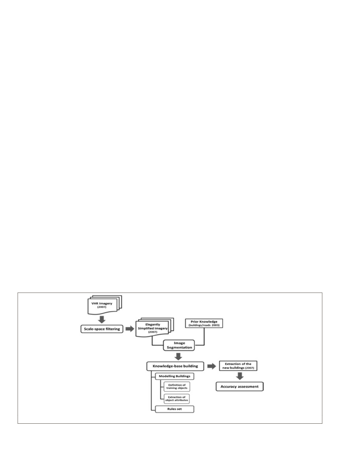
image analysis. The flowchart of the developed approach is
shown in Figure 1.
Figure 1. The flowchart of the proposed change detection methodology.
482
June 2015
PHOTOGRAMMETRIC ENGINEERING & REMOTE SENSING


