on the mean values of the Euclidean distances among all the
points of two objects A= {a
1
, …, a
N
a
} and B= {b
1
, …, b
N
b
},
i.e.
,
the distance of A from B is d(A,B) =
1
N
a
∑
a
∈
A
d(a,B).
The maximum of the two distances is the distance of interest
f(d(A,B), d(B,A)) = max (d(A,B), d(B,A)).
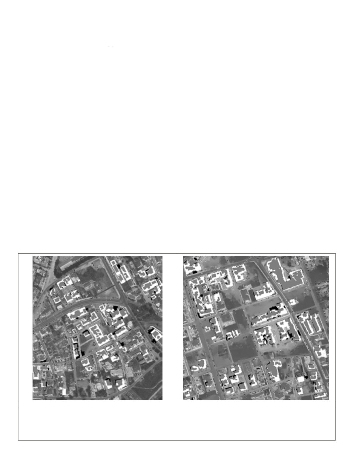
In the Pylaia suburb (Figure 6a), the knowledge-based
model succeeded in identifying almost all (except one) new
buildings which were constructed during the 2003 to 2007
period. The corresponding quantitative evaluation reported
completeness rates at around 99 percent and 60 percent in
the object- and pixel-based evaluation procedure, respec-
tively. Three objects were falsely identified as buildings
(false alarms) and the overall correctness of the methodology
reached 96 percent in the object-based and 88 percent in the
pixel-based evaluation. The overall quality of the methodol-
ogy was relatively high with 95 percent object-based and 55
percent in the pixel-based evaluation. The accuracy assess-
ment of the geometrical position of the polygons detected as
new buildings was accomplished by comparing them with the
reference polygons. The centroids’ distance and the modi-
fied distance Haussdorff were calculated and the results are
presented in Table 3. The mean distances between the cen-
troids were around three (3) meters, indicating that the model
correctly identified the position of the buildings taking into
consideration the different shape of the reference polygons.
The mean value of the maximum distance between the gener-
ated polygons’ border and the reference polygons (distance
Haussdorff) was approximately four (4) meters.
When the model was applied in the study area of Kalamaria,
72 out of the 76 new buildings were identified correctly (
Figure
6b
), with the Completeness around 95 percent for the object-
based and 52 percent for the pixel-based comparison. The
percentage of the results in conformity with the reference data
was 98 percent when the objects were involved and 87 percent
in the case of pixels. This shows that only a small number of
objects (false alarms) were in correctly detected as buildings.
The shortcoming of the model in this case was the inability to
detect the whole part of the buildings, so the overall quality of
the methodology was relatively good for the objects (93 per-
cent), but relatively low for the pixels (49 percent).
The mean value of the centroids’ distances was estimated
around five (5) meters, due to the fact that the classification
procedure resulted, in most cases, into several building ob-
jects which were all part of a unique reference polygon. Thus,
the centroids of the objects corresponding to a building were
rather far from the centroid of the reference polygon. Similar
results were acquired for the Haussdorff distance.
Conclusions
A knowledge-based classification procedure was developed
to enable building change detection in urban environments
by exploiting the spectral information of very high resolution
multispectral imagery and the vector information from exist-
ing geodatabases. The main goal was to design a change detec-
tion framework able to identify changes based on the mini-
mum available and cost-effective data, such as a multispectral
satellite image and existing maps. The developed methodol-
ogy integrates advanced scale-space filtering, unsupervised
clustering and knowledge-based classification procedures.
Both the qualitative and quantitative validation indicated high
accuracy rates during the per-object evaluation and almost all
changes (new buildings) have been detected in all the cases.
The algorithm scores lower during the per-pixel evaluation,
since it cannot adequately detect the entire rooftops. This
is mainly due to the off-nadir image acquisition angles that
depict not only the roofs, but also parts of building facades,
hindering in such way the accurate definition of the geometric
statistical properties and features like shape and size. Em-
ploying true-orthophoto datasets could of course solve this
problem, but this solution would be time consuming and not
cost effective. Moreover, in our implementations, the complex
(a)
(b)
Figure 6. The study areas of (a) Pylaia, and (b) Kalamaria. Both the qualitative and the quantitative evaluation of the developed change
detection framework indicate high accuracy rates during the per-object evaluation. Almost all changes (new buildings) have been de-
tected. The algorithms scores lower during the per-pixel evaluation since it cannot adequately detect the entire rooftops. The grey pixels
are the correctly detected changes (True Positives), the black pixels are the false alarms (False Positives) and the white pixels are have
not been detected (False Negatives).
488
June 2015
PHOTOGRAMMETRIC ENGINEERING & REMOTE SENSING


