412
July 2018
PHOTOGRAMMETRIC ENGINEERING & REMOTE SENSING
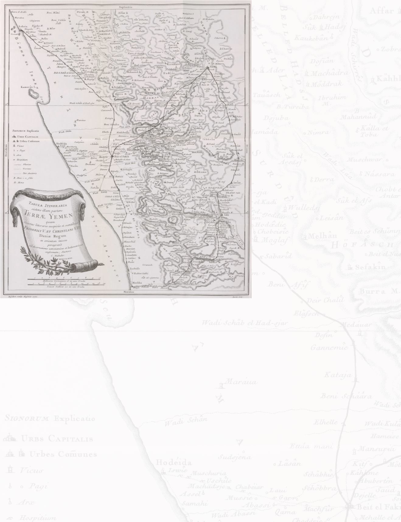
botanist, a philologist, an artist and a
surveyor, all of whom save the survey-
or failed to survive the trip. That man
was Carsten Niebuhr, whose detailed
diaries and the works of his compatriots
provided the first detailed cartograph-
ically corrected maps of southwestern
Arabia. Even so, the expedition dared
not to enter the interior, beyond the
reaches of Sana, the interior capital of
Yemen. (Figure 4),
It should be noted that the Bedouin
tribes and city residents of Arabia, were
not in any way ignorant of their region-
al geography; only that this knowledge
was not readily shared with outsiders.
Nor would it seem that the majority of
the outside world, with the exception of
the heretofore mentioned geographers,
Figure 4. By Oksana Yurchyshyn-Smith - Own work, CC BY-SA 4.0,
cared to explore the desert vastness of
Arabia’s interior. The Danish expe-
dition proved however to provide the
needed impetus and curiosity necessary
to spark the imagination of European
explorers and created a new breed of
traveler and explorer, the Orientalist.
Among the many notable men and
women who became synonymous with
Orientalism, the most accomplished
were: Johann Ludwig Burckhardt
(1784-1817), Gillford Palgrave, (1826-
1888), Richard Francis Burton (1821-
1890) and Charles Montagu Doughty
(1843-1926). It was Doughty who first
sought to bring into the European
sphere, the native knowledge and
understanding of Arabian geography
and culture to the west. When gather-
ing information from the tribal peoples
of the region, he totally disregarded
previous European ‘theories’ and relied
exclusively on the native knowledge.
Doughty’s journeys throughout the
region in the 1870’s brought to light the
true extent of the Arabian interior and
were related in his 1888 book ‘Travels
in Arabia Deserta’ (two volumes) with
the actual Arabic place names rather
than westernized versions. Unfortu-
nately, most of his records were never
taken as far as a cartographers table,
and it wasn’t until later Orientalists
sought out the most qualified resources
for their own journey’s that his work
was rediscovered and given such high
praise.
A World at War
Whilst prior exploration of the Arabian
Peninsula, and its sporadic mapping
and exploration had been constrained
largely due to the geographic isolation
and desolate sandy wastes of its interi-
or, it had also been politically protected.
The Ottoman Empire had jealously
guarded its fiefdoms for centuries, but
in the latter half of the 19
th
century,
after suffering numerous territorial
losses, it decided to ally itself with
the Central Powers in the first World
War. While this was a conscious effort
to regain its lands and influence, this
decision opened the Empire to a flood
of military exploration. Consequently,
a new breed of military Orientalist
Cartographer was born.
Several renowned war time explorers
came to the forefront during this period.
The doomed Captain William Shake-
spear (1878-1915), famous Colonel T.E.
Lawrence (1888-1935), the infamous
Gertrude Bell (1868-1926), the staunch
Anglophile Freya Stark (1893-1993)
and the turn-coat Harry St. John Philby
(1885-1960). These: soldiers, explorers
and spies, leaned heavily upon Dough-
ty’s books, but also brought the most
modern aspects of the period to accu-
rately mapping the routes of Arabia.
(Figure 5).


