PHOTOGRAMMETRIC ENGINEERING & REMOTE SENSING
April 2020
205
My biggest joy is that we successfully mapped all of Alaska,
consistently meeting or exceeding USGS’ specifications, at a
total cost of $66.3M, rather than the $77.3M originally esti-
mated. This is a tribute to cost efficiencies by all involved.
My second joy is knowing the vast improvement in usability
of IfSAR DEMs compared to the prior DEMs from the NED.
y
In preparing the initial Alaska DEM Whitepaper, I
learned of the importance of hydro features to Alaskans.
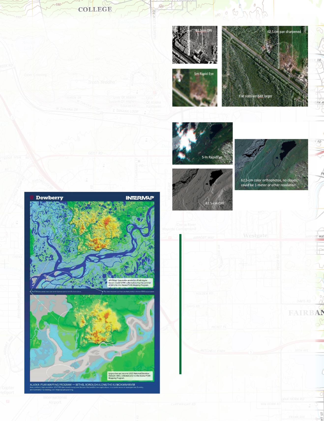
Figure 6 (courtesy of Intermap) shows the richness of the
hydro features from IfSAR, compared with sparse hydro
features in the NED. Hydro-enforced IfSAR DTMs are
now being used to update National Hydrography Data-
sets (NHD) throughout Alaska.
y
I also learned of the importance of being able to map
through clouds and produce digital orthoimages. Figure
7 shows how higher-resolution greyscale IfSAR ORIs can
be used to pan-sharpen lower-resolution color satellite
imagery; and Figure 8 demonstrates how IfSAR ORIs can
be used to produce color orthophotos, even when satellite
images are cloudy.
Figure 6.Aerial IfSAR (top) of Kuskokwim River compared with the prior NED
(bottom). IfSAR hydro features are extremely rich.
Figure 7.This figure demonstrates how to pan-sharpen 5m color satellite
imagery with 62.5-cm greyscale IfSAR ORIs.
Figure 8.This figure demonstrates how IfSAR ORIs can be used to pan-sharp-
en cloudy satellite imagery – mapping through the clouds.
“The detailed mapping of elevation in the State of
Alaska significantly improves the economy, quality of life
and safety of our largest State. It satisfied needs for
flood modeling, flight safety, precision forestry, landslide
modeling, critical minerals assessments, natural resource
assessments, and transportation and infrastructure
development. And while the data that has been collected
has significant value today, it will be even more
valuable 20, 30 or 50 years from now as it will provide
a baseline for which changes can be measured. For
example, changes in shoreline, glacial mass, subsidence
and hydrologic regime. It raises Alaska to the modern
mapping standard and it opens the door for the next
chapter in the future of Alaska, a future that recognizes
Alaska as a natural resource wonder, a thriving economy
and strategic national security interest.” By Kevin T.
Gallagher, USGS Associate Director, Core Science Systems.
“
“
What are your greatest joys, now
that the project is complete?


